Terre-de-Haut

Last updated • 1 min readFrom Wikipedia, The Free Encyclopedia
Terre-de-Haut
Eglise de Terre-de-Haut.jpg
The church of Terre-de-Haut
Armoiries Terre-de-Haut(Saintes).svg
Terre-de-Haut.png
Location of the commune (in red) within Guadeloupe
Location of Terre-de-Haut
Terre-de-Haut
Coordinates: 15°52′00″N61°35′00″W / 15.8667°N 61.5833°W / 15.8667; -61.5833
Country France
Overseas region and department Guadeloupe
Arrondissement Basse-Terre
Canton Trois-Rivières
Intercommunality CA Grand Sud Caraïbe
Government
  Mayor (20232026) Louly Bonbon [1]
Area
1
6.00 km2 (2.32 sq mi)
Population
 (2021) [2]
1,496
  Density250/km2 (650/sq mi)
Time zone UTC−04:00 (AST)
INSEE/Postal code
97131 /97137
Elevation0–306 m (0–1,004 ft)
1 French Land Register data, which excludes lakes, ponds, glaciers > 1 km2 (0.386 sq mi or 247 acres) and river estuaries.

Terre-de-Haut (French pronunciation: [tɛʁʔo] ; Guadeloupean Creole : Tèdého) is a commune in the French overseas department of Guadeloupe, including Terre-de-Haut Island and a few other small uninhabited islands of the archipelago (les Roches Percées; Îlet à Cabrit ; Grand-Îlet ; la Redonde). It is the most populous island of the archipelago of Les Saintes. The Fort Napoléon is located in this commune.

Contents

Tourism

Terre-de-Haut is the most tourist-friendly municipality in les Saintes archipelago, with hotels, bungalows, bars and restaurants. There is little formalized activity, but one can tour the restored Fort Napoleon or rent mopeds. Located there is the beautiful Plage de Pompierre beach, [3] as well as small guest-houses, eateries, French-Creole shops, and an active harbour where ferries passengers from Guadeloupe arrive. The local people make a living from fishing and from tourism. Visitors are free to explore without modern-day intrusion. The local currency is the Euro, but credit cards are easily accepted. A small airport was built on the island in 1973 to welcome private planes from Guadeloupe and other nearby Caribbean islands.

History

List of the successive mayors
PeriodIdentityPartyQuality
2023–Louly Bonbon
2020–2023Hilaire Brudey Parti socialiste
2018–2020Louly Bonbon DVD
2000–2018Louis Molinié UMP
1977–2000Robert Joyeux RPR
1971–1977René Germain
1961–1971Eugène Samson
1957–1961Georges Azincourt
1936–1957Théodore Samson
1929–1935Benoît Cassin
1915–1928Emmanuel Laurent
1911–1914Paul-Eugène Thomas
1902–1908Benoit Cassin
1892–1902Charles Foy
1884–1892Bernard Azincourt
1882–1884Charles FoyFirst mayor of Terre-de-Haut
1871–1882Jean-Pierre LognosLast mayor of les Saintes
The previous data are not mentioned yet.

Demographics

Historical population
YearPop.±% p.a.
19671,474    
19741,453−0.20%
19821,474+0.18%
19901,527+0.44%
19991,729+1.39%
20071,854+0.88%
20121,773−0.89%
20171,532−2.88%
Source: INSEE [4]

Points of interest

Education

Public preschools and primary schools: [5]

See also

Related Research Articles

<span class="mw-page-title-main">Bouillante</span> Commune in Guadeloupe, France

Bouillante is a commune in the French overseas region and department of Guadeloupe, in the Lesser Antilles.

<span class="mw-page-title-main">Deshaies</span> Commune in Guadeloupe, France

Deshaies is a commune in the French overseas region and department of Guadeloupe, in the Lesser Antilles. It is on the northwest coast of Basse-Terre Island.

<span class="mw-page-title-main">Baillif</span> Commune of Guadeloupe

Baillif is a commune of Guadeloupe, an overseas region and department of France located in the Lesser Antilles. Baillif is a suburb of Basse-Terre, the prefecture and the second-largest urban area of Guadeloupe located on Basse-Terre Island.

<span class="mw-page-title-main">Capesterre-Belle-Eau</span> Commune in Guadeloupe, France

Capesterre-Belle-Eau is a commune in the French overseas region and department of Guadeloupe, in the Lesser Antilles. It is located in the south-east of Basse-Terre Island. Capesterre-Belle-Eau covers an area of 103.3 km2. The 1999 population was 19,568. The population density is 189 persons per km2. The inhabitants are called Capesterriens.

<span class="mw-page-title-main">Pointe-à-Pitre</span> Subprefecture, commune, and the center of the largest metropolitan area in Guadeloupe

Pointe-à-Pitre is the second most populous commune of Guadeloupe. Guadeloupe is an overseas region and department of France located in the Lesser Antilles, of which it is a sous-préfecture, being the seat of the Arrondissement of Pointe-à-Pitre.

<span class="mw-page-title-main">Îles des Saintes</span> Group of islands in Guadeloupe, overseas France

The Îles des Saintes, also known as Les Saintes, is a group of small islands in the archipelago of Guadeloupe, an overseas department of France. It is part of the Canton of Trois-Rivières and is divided into two communes: Terre-de-Haut and Terre-de-Bas. It is in the arrondissement of Basse-Terre and also in Guadeloupe's 4th constituency.

<span class="mw-page-title-main">Terre-de-Bas Island</span>

Terre-de-Bas Island is an island in the Îles des Saintes archipelago, in the Lesser Antilles.

<span class="mw-page-title-main">Petit-Bourg</span> Commune in Guadeloupe, France

Petit-Bourg is the seventh-largest commune in the French overseas department of Guadeloupe. It is located on the east side of the island of Basse-Terre, and is part of the metropolitan area of Pointe-à-Pitre, the largest metropolitan area in Guadeloupe.

<span class="mw-page-title-main">Gourbeyre</span> Commune in Guadeloupe, France

Gourbeyre is a commune in the French overseas region and department of Guadeloupe, in the Lesser Antilles. It is a suburb of the city of Basse-Terre.

<span class="mw-page-title-main">Vieux-Habitants</span> Commune in Guadeloupe, France

Vieux-Habitants is a commune on Guadeloupe, a French overseas department in the Caribbean. It is located on the southwest coast of the island of Basse-Terre.

<span class="mw-page-title-main">Grand-Bourg</span> Commune in Guadeloupe, France

Grand-Bourg, also known as Grand-Bourg de Marie-Galante, is a commune on the island of Marie-Galante, in the French overseas region and department of Guadeloupe, in the Lesser Antilles, Caribbean. It is located in the southwest of Marie-Galante, and is the most populous of the three communes on the island.

<span class="mw-page-title-main">Terre-de-Bas</span> Commune in Guadeloupe, France

Terre-de-Bas is a commune in the French overseas department and region of Guadeloupe, in the Lesser Antilles. Terre-de-Bas is made up of Terre-de-Bas Island and several uninhabited islands and islets in the group of Les Saintes islands, to the southwest of Guadeloupe's mainland.

<span class="mw-page-title-main">Goyave</span> Commune in Guadeloupe, France

Goyave is a commune in the French overseas region and department of Guadeloupe, Lesser Antilles. It is part of the urban area of Pointe-à-Pitre, the largest metropolitan area in Guadeloupe.

<span class="mw-page-title-main">Saint-Claude, Guadeloupe</span> Commune in Guadeloupe, France

Saint-Claude is a commune in the French overseas department of Guadeloupe. It lies in the interior of southern Basse-Terre Island, just northeast of the capital city of Basse-Terre.

<span class="mw-page-title-main">Port-Louis, Guadeloupe</span> Commune in Guadeloupe, France

Port-Louis is a commune in the department of Guadeloupe, on the northwest of Grande-Terre.

<span class="mw-page-title-main">Sainte-Rose, Guadeloupe</span> Commune in Guadeloupe, France

Sainte-Rose is a commune in the department of Guadeloupe. It is the second largest commune of Guadeloupe, in terms of area, after Petit-Bourg. Sainte-Rose lies on the coast of the island of Basse-Terre.

<span class="mw-page-title-main">Trois-Rivières, Guadeloupe</span> Commune in Guadeloupe, France

Trois-Rivières is a commune in the overseas department of Guadeloupe, and the chef-lieu of the Canton of Trois-Rivières. It is on the south coast of the island of Basse-Terre. It is surrounded with the towns of Capesterre-Belle-Eau, Vieux-Fort and Gourbeyre.

<span class="mw-page-title-main">Terre-de-Haut Island</span> Island in Guadeloupe

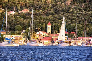
Terre-de-Haut Island is the easternmost island in the Îles des Saintes, part of the archipelago of Guadeloupe. Like name of neighboring Terre-de-Bas Island, name Terre-de-Haut comes from the maritime vocabulary, which called the islands exposed to the "highland" winds and those protected from the wind, "lowlands".

<span class="mw-page-title-main">Index of Guadeloupe-related articles</span>

Articles related to the French overseas department of Guadeloupe include:

<span class="mw-page-title-main">Îlet à Cabrit</span>

Îlet à Cabrit, officially French: îlet à Cabrit des Saintes, is an island in the Îles des Saintes, Guadeloupe, the Lesser Antilles. It belongs to the commune of Terre-de-Haut.

References

  1. "Répertoire national des élus: les maires" (in French). data.gouv.fr, Plateforme ouverte des données publiques françaises. 6 June 2023.
  2. "Populations légales 2021" (in French). The National Institute of Statistics and Economic Studies. 28 December 2023.
  3. "Iles des Saintes". le-caribbean-islands.com. Archived from the original on 28 March 2010. Retrieved 7 December 2010.
  4. Population en historique depuis 1968, INSEE
  5. "LISTE DES ECOLES PUBLIQUES ET PRIVEES SOUS CONTRAT." Académie de la Guadeloupe  [ fr ]. Retrieved on 10 March 2018.
The bay des Saintes IlesDesSaintes.jpg
The bay des Saintes