Beginning 1635 with the arrival of the French and during the 17th century, the village was called Portland. The principal part of the city was located on the actual site of Autre Bord, towards the east. During the 18th century, the city became the stronghold for colonial aristocracy and the center moved to the left bank of river Audoin. This was thanks to the development of sugar cane and for a better placement of the port on the Atlantic Ocean. A lot of important construction took place to protect and improve the city, one of which was a breakwater ("mole" in French) that gave the city its new name, Le Moule, that became Guadeloupe's main commercial port. On September 20, 1828, Le Moule received rights to export its commodities to the metropolitan France without going through Pointe à Pitre. Thus having direct contact with French territory, it became a target for the British fleet during the Napoleon war at the beginning of the 19th century. The heroic battle of 1809 remains a historic date for Guadeloupe.
In practice, all sugar cane, sugar and rum produced in Grande Terre were shipped from Le Moule's port. Consequently, the city enjoyed a flourishing commerce that was further supplemented by shipments of coffee, cotton, fertilizer, coal, building material and spare parts.
During the first half of the 19th century with its numerous refineries and plantations (at first about 30, then about 100), the planters lived a self-sufficient lifestyle farming sugar cane, coffee, cotton, cocoa, spices and other essential food products, thus dominating Guadeloupean economics during the 1850s. After that, they experienced many financial collapses because of failed crops, abolition of slavery, the production of better sugar in Europe and the very strict "colonial pact". Shared farming has become necessary as well as industrial modernization, and steam machines replaced traditional windmills. The sugar crises forced a new decision. In 1901, only four refineries survived: Duchassaing, Zévallos, Marly and Gardel. Le Moule's port lost its place of dominance to Pointe à Pitre, the center of commerce shifted and the city fell into solitude.
The devastating cyclone of 1928 was the sounding force and the point of return for the community. The city not only rose from its ruins thanks to Mayor Charles Romana, but it also constructed new buildings: the townhouse, schools, churches, roads and parks.
In 2002, Gabrielle Louis-Carabin became the mayor of Le Moule, and is also a member of the general council of Guadeloupe.
Le Moule's history, the richest on the island, enabled it to maintain many remains and relics, and to develop centers of interest around them.
Le Moule is on the island of Guadeloupe in Caribbean, near the Equator. The town experiences warm/hot temperatures at day and cool temperatures at night. The temperature range at daytime vary between 80°F (27°C) to 84°F (29°C) between October–May & 84°F (29°C) to 90°F (32°C), sometimes above 90°F (32°C) between. The heat and humidity are higher from July to October.
Climate data for Le Moule (Laureal, altitude 24m, 1991–2020 normals, extremes 1994–present)
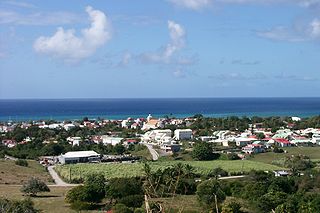
Le Moule was a sugar port in the 17th-18th centuries. Now tourism has boomed and there are some seaside resorts on nearby beaches. There are two distilleries nearby. Agriculture is predominantly spread around Le Moule with fields growing bananas, sugarcane and livestock rearing.
Zévallos PlantationThe old portThe city hallLe Moule surf spot
Sights
There are an array of sights to see either in or around Le Moule.
The Damoiseau Distillery is in Bellevue in the middle of a sugar cane field. Production is limited to white rum, old vintage rum and punches, all of which have received numerous awards for their quality.
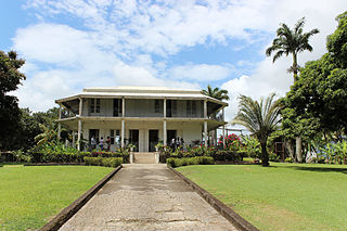
The Gardel Plant was built under the reconstruction plan for the agriculture sector in 1870, after the historic financial collapse. It is owned by Générale Sucrière, the world leader in the sugar refinery industry. It is the sole refinery on the main island of Guadeloupe and, consequently, a symbol. Its installation in the epicenter of sugar cane plantations affords heavy production from March to July.
The Ouatibi-Tibi Archaeological Park is situated in Morel on 7 hectares of beach that run alongside the lagoon. This is a place for taking strolls, for relaxing and meditating. It is intensely rich in culture and is composed of three sites: a memorial center, an archaeological center and a recreation center.
The Edgar Clerc Museum is a prehistoric pre-Columbian and Amerindian museum unique to the island. It is located west of the city. It showcases the traditions of the Tainos, Caribs, Arawaks and the Caribbean peoples through its collections of pottery and tools found at the diggings of the archaeological park in Morel.[9][10]
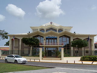
The town hall was reconstructed after the 1928 cyclone by Ali Tur (son of a high ranking government official). Its massive round forms protect it from the natural elements.
In the Moulian countryside are many windmills in sugarcane fields. These were indispensable for grinning the sugar cane before the arrival of steam machines that had larger flat capacity grinners.[clarification needed] Dating back to the 18th century, some are still well maintained. The "tour des moulins" (trail of windmills) makes a pleasant route for mountain bike practice.
The Church of Saint Jean Baptiste was constructed in the form of a Latin cross, a neoclassic inspiration. Since its reconstruction in 1840, it has resisted numerous cyclones. Its exceptional ventilation system preserves, wholly intact, a woody decor in pastel tones.
There are many hotels and restaurants which serve French, Continental, Creole and American dishes. There are also a couple of beaches: L'Autre Bord, a sea-grape shaded beach on the way into Le Moule, and Plage des Baies, about 1km (0.62mi) north, which forms a shallow bay ideal for swimmers.
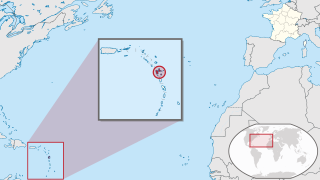
Guadeloupe is an archipelago and overseas department and region of France in the Caribbean. It consists of six inhabited islands—Basse-Terre, Grande-Terre, Marie-Galante, La Désirade, and the two inhabited Îles des Saintes—as well as many uninhabited islands and outcroppings. It is south of Antigua and Barbuda and Montserrat, north of the Commonwealth of Dominica. The region's capital city is Basse-Terre, located on the southern west coast of Basse-Terre Island; however, the most populous city is Les Abymes and the main centre of business is neighbouring Pointe-à-Pitre, both located on Grande-Terre Island. It had a population of 384,239 in 2019.
Anse-Bertrand is a commune in Guadeloupe, an overseas region and department of France in the Lesser Antilles.
Baie-Mahault is a commune in the overseas department and region of Guadeloupe, France. It is the second most populated commune of Guadeloupe, after Les Abymes. The extensive industrial zone of Jarry in Baie-Mahault is by far the most industrialized commune in the islands and the largest industrial park in the Lesser Antilles. It is part of the urban area of Pointe-à-Pitre, the largest metropolitan area in Guadeloupe, located in the northwest.
Bouillante is a commune in the French overseas region and department of Guadeloupe, in the Lesser Antilles.
Capesterre-Belle-Eau is a commune in the French overseas region and department of Guadeloupe, in the Lesser Antilles. It is located in the south-east of Basse-Terre Island. Capesterre-Belle-Eau covers an area of 103.3 km2. The 1999 population was 19,568. The population density is 189 persons per km2. The inhabitants are called Capesterriens.
Pointe-à-Pitre is the second largest city of Guadeloupe after Les Abymes. Guadeloupe is an overseas region and department of France located in the Lesser Antilles, of which it is a sous-préfecture, being the seat of the Arrondissement of Pointe-à-Pitre.
Marie-Galante is one of the islands that form Guadeloupe, an overseas department of France. Marie-Galante has a land area of 158.1 km2. It had 11,528 inhabitants at the start of 2013, but by the start of 2018 the total was officially estimated to be 10,655, with a population density of 62.5/km2 (162/sq mi).
Le Gosier is a commune in the French overseas region and department of Guadeloupe, in the Lesser Antilles. It is located on the south side of the island of Grande-Terre and part of the urban unit of Pointe-à-Pitre-Les Abymes, the largest conurbation in Guadeloupe.
Petit-Bourg is the seventh-largest commune in the French overseas department of Guadeloupe. It is located on the east side of the island of Basse-Terre, and is part of the metropolitan area of Pointe-à-Pitre, the largest metropolitan area in Guadeloupe.
Gourbeyre is a commune in the French overseas region and department of Guadeloupe, in the Lesser Antilles. It is a suburb of the city of Basse-Terre.
Pointe-Noire is a commune on Guadeloupe, a French overseas department in the Caribbean. It is located on the northwest coast of the island of Basse-Terre.
Vieux-Habitants is a commune on Guadeloupe, a French overseas department in the Caribbean. It is located on the southwest coast of the island of Basse-Terre.
Capesterre-de-Marie-Galante is a commune on the island of Marie-Galante, in the French overseas region and department of Guadeloupe, itself in the Lesser Antilles.
Grand-Bourg is a commune on the island of Marie-Galante, in the French overseas region and department of Guadeloupe in the Lesser Antilles Caribbean. It is located in the southwest of Marie-Galante, and is the most populous of the three communes on the island.
Goyave is a commune in the French overseas region and department of Guadeloupe, Lesser Antilles. It is part of the urban area of Pointe-à-Pitre, the largest metropolitan area in Guadeloupe.
Lamentin is a commune in the French overseas department and region of Guadeloupe. It is part of the agglomeration of Pointe-à-Pitre, in the north part of Basse-Terre. Three islets are included in the commune: Christopher, Fajou, Caret.
Port-Louis is a commune in the department of Guadeloupe, on the northwest of Grande-Terre.
Gardel is a settlement in Guadeloupe in the commune of Le Moule, on the island of Grande-Terre. Boisvin is to its west, and Zevallos is to its east; to the north are Guillocheau, Laureal, Portland and Guenette.
Articles related to the French overseas department of Guadeloupe include:
Damoiseau is a rhum agricole distillery located in Le Moule, Guadeloupe. It is one of five distilleries in the Guadeloupe archipelago, and the only one in the Grande-Terre region. It has roots back to the 19th century and was originally founded as an agricultural estate. Damoiseau is the leading rum producer in Guadeloupe, producing more than 8 million litres per year and exported to more than 40 countries worldwide.
↑ "Le Moule Gardel–Inra (971)"(PDF). Fiche Climatologique: Statistiques 1981–2010 et records (in French). Meteo France. Archived from the original(PDF) on 30 March 2018. Retrieved 29 March 2018.
This page is based on this Wikipedia article Text is available under the CC BY-SA 4.0 license; additional terms may apply. Images, videos and audio are available under their respective licenses.