
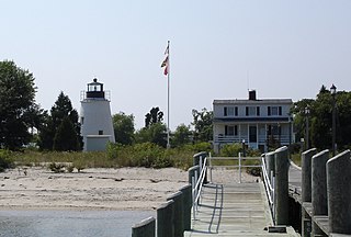
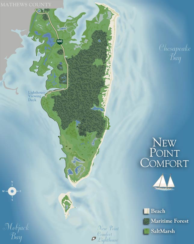
New Point Comfort is a point of land located in Mathews County at the tip of Virginia's Middle Peninsula in the lower Chesapeake Bay in the United States. It is the site of the New Point Comfort Natural Area Preserve and the New Point Comfort Light.
New Point Comfort is a point of land located in Mathews County at the tip of Virginia's Middle Peninsula in the lower Chesapeake Bay in the United States. It is the site of the New Point Comfort Natural Area Preserve and the New Point Comfort Light.
The tip New Point Comfort is now on an island separated from the mainland of Mathews County south of the unincorporated town of Bavon at the mouth of Mobjack Bay. It is 21 miles (34 km) north of Old Point Comfort in Phoebus, Hampton. The peninsula to the north of the point, from Peppers Creek and Horn Harbor southward, is also called New Point Comfort.
English explorer John Smith passed by New Point Comfort in 1608 when returning to Jamestown from the northern Chesapeake Bay. The New Point Comfort Light was built from 1802–1805 and by 1852, it was partially cut off by the sea and formed a new island. In 1904, the New Point Comfort Development Company was formed to build a resort on the peninsula by reclaiming the marsh that separated the lighthouse from the mainland and building beaches. However, the prohibitive cost doomed the project and the business went bankrupt. In 1933, the Chesapeake Potomac Hurricane and the Outer Banks Hurricane definitively severed the lighthouse from the mainland and it now is about one and a half miles (2.4 km) from shore on a small riprap island.
37°18′07″N76°16′39″W / 37.30194°N 76.27750°W
| | This Mathews County, Virginia state location article is a stub. You can help Wikipedia by expanding it. |

The Delmarva Peninsula, or simply Delmarva, is a peninsula on the East Coast of the United States, occupied by the majority of the state of Delaware and parts of the Eastern Shore of Maryland and Eastern Shore of Virginia.

Mathews County is a county located in the U.S. state of Virginia. As of the 2020 census, the population was 8,533. Its county seat is Mathews.

Saxis is a town in Accomack County, Virginia, United States. The population was 241 at the 2010 census.

The Middle Peninsula is the second of three large peninsulas on the western shore of Chesapeake Bay in Virginia. To the north the Rappahannock River separates it from the Northern Neck peninsula. To the south the York River separates it from the Virginia Peninsula. It encompasses six Virginia counties: Essex, Gloucester, King and Queen, King William, Mathews, and Middlesex. Developed for tobacco plantations in the colonial era, in the 21st century the Middle Peninsula is known for its quiet rural life, vegetable truck-farming, and fishing industry. As of the 2020 census, the Middle Peninsula was home to 92,886 people.

The York River is a navigable estuary, approximately 34 miles (55 km) long, in eastern Virginia in the United States. It ranges in width from 1 mile (1.6 km) at its head to 2.5 miles (4.0 km) near its mouth on the west side of Chesapeake Bay. Its watershed drains an area of the coastal plain of Virginia north and east of Richmond.

Long Beach Island is a barrier island and summer colony along the Atlantic Ocean coast of Ocean County, New Jersey, United States, on the Jersey Shore. Aligned north to south, the northern portion generally has more expensive low-density housing, whereas the southern portion possesses higher-density housing and considerable commercial development. Long Beach Island is 1-2 miles away from Mainland New Jersey. The primary industries include tourism, fishing, and real estate. The only access point to the island by land is a single causeway. The island is the southernmost point of the New York Metropolitan Area.

The Eastern Shore of Virginia is the easternmost region of the Commonwealth of Virginia in the United States. It consists of two counties on the Atlantic coast. It is detached from the mainland of Virginia by the Chesapeake Bay. The 70-mile-long (110 km) region is part of the Delmarva Peninsula. Its population was 45,695 as of 2020.
Old Point Comfort is a point of land located in the independent city of Hampton, Virginia. Previously known as Point Comfort, it lies at the extreme tip of the Virginia Peninsula at the mouth of Hampton Roads in the United States. It was renamed Old Point Comfort to differentiate it from New Point Comfort 21 miles (34 km) up the Chesapeake Bay. A group of enslaved Africans was brought to colonial Virginia at this point in 1619. Today the location is home to Continental Park and Fort Monroe National Monument.

Willoughby Spit is a peninsula of land in the independent city of Norfolk, Virginia in the United States. It is bordered by water on three sides: the Chesapeake Bay to the north, Hampton Roads to the west, and Willoughby Bay to the south.

Kent Island is the largest island in the Chesapeake Bay and a historic place in Maryland. To the east, a narrow channel known as the Kent Narrows barely separates the island from the Delmarva Peninsula, and on the other side, the island is separated from Sandy Point, an area near Annapolis, by roughly four miles (6.4 km) of water. At only four miles wide, the main waterway of the bay is at its narrowest at this point and is spanned here by the Chesapeake Bay Bridge. The Chester River runs to the north of the island and empties into the Chesapeake Bay at Kent Island's Love Point. To the south of the island lies Eastern Bay. The United States Census Bureau reports that the island has 31.62 square miles (81.90 km2) of land area.

The St. Joseph Point Light was a lighthouse on the mainland north of present-day Port St. Joe, Florida, across the entrance to St. Joseph Bay from St. Joseph Point. St. Joseph Bay is enclosed by St. Joseph Peninsula, which runs west some three miles (5 km) from the mainland to Cape San Blas, and then northerly 15 miles (24 km) to St. Joseph Point. An earlier light in the area was the St. Joseph Bay Light.

The Back River is an estuarine inlet of the Chesapeake Bay between the independent cities of Hampton and Poquoson in the Hampton Roads area of southeastern Virginia. Formed by the confluence of the Northwest and Southwest Branches, and at just over two miles (3.2 km) long, the Back River is a breeding ground for many of the Bay's prized sport fish and the well known blue crab. The river was once part of an important fishing area that provided the local canneries with the famous Chesapeake seafood that was, and still is in demand throughout the country. Although now used primarily for recreation and as a wildlife refuge, the river remains a place for fishing and laying crab traps. Factory Point, a peninsula that protects the river from the Chesapeake Bay sits at the mouth of the river adjoining the bay.
Elzy Burroughs (1771/77–1825) was an American stonemason, engineer, lighthouse builder and keeper.
The Piney Point Lighthouse was built in 1836 located at Piney Point on the Potomac River in Maryland just up the river from the mouth of the Chesapeake Bay. The Coast Guard decommissioned it in 1964 and it has since become a museum. It is known as the Lighthouse of Presidents because several early US Presidents visited or stayed on the grounds.
Bodie Island is a long, narrow barrier peninsula that forms the northernmost portion of the Outer Banks. The land that is most commonly referred to as Bodie Island was at one time a true island, but in 1811 Roanoke Inlet, which had separated it from the Currituck Banks in the north, closed. As a result, the Currituck Banks and Bodie Island are now one contiguous peninsula, joined at the Nags Head area, where the inlet once flowed. Today, either name can be used to refer to the peninsula as a whole, but both portions colloquially retain their historical names.

New Point Comfort Light is a lighthouse in the Virginia portion of the Chesapeake Bay, United States, off the tip of the Middle Peninsula. Finished in 1804, it is the third-oldest surviving light in the bay, and the tenth-oldest in the United States.

Factory Point is a land peninsula separating the Back River and the Chesapeake Bay in the Commonwealth of Virginia.
The Hog Island Light was a lighthouse roughly marking its eponymous island, and thus the north side of the Great Machipongo Inlet on the Virginia coast. Originally, no light existed between Cape Henlopen, Delaware and Cape Charles. In 1830 the United States Congress appropriated money for a coastal beacon in the general vicinity of Chincoteague Island. The following year, the Collector of Customs in Norfolk selected Assateague Island.
The Piankatank River is a 24.4-mile-long (39.3 km) river in the U.S. state of Virginia. Located on the Middle Peninsula, between the Rappahannock and York rivers, it was the site of numerous actions during the American Civil War.

The Virginia Barrier Islands are a continuous chain of long, narrow, low-lying, sand and scrub barrier islands separated from one another by narrow inlets and from the mainland by a series of shallow marshy tidal bays along the entire coast of the Virginia end of the Delmarva Peninsula. Several of these islands were once significantly larger, covered with pine forests, and inhabited. After the completion of the New York, Philadelphia and Norfolk Railroad in the late 19th Century, at least five lavish hunting and fishing clubs were established on Virginia's barrier islands and they became a playground for wealthy sportsmen from Northeastern cities who would arrive by train. US President Grover Cleveland visited Hog Island to hunt waterfowl and go fishing in the early 1890s.