
Tropical Storm Allison was a tropical storm that devastated southeast Texas in June of the 2001 Atlantic hurricane season. An arguable example of the "brown ocean effect", Allison lasted unusually long for a June storm, remaining tropical or subtropical for 16 days, most of which was when the storm was over land dumping torrential rainfall. The storm developed from a tropical wave in the northern Gulf of Mexico on June 4, 2001, and struck the upper Texas coast shortly thereafter. It drifted northward through the state, turned back to the south, and re-entered the Gulf of Mexico. The storm continued to the east-northeast, made landfall on Louisiana, then moved across the southeast United States and Mid-Atlantic. Allison was the first storm since Tropical Storm Frances in 1998 to strike the northern Texas coastline.

The 1995 Atlantic hurricane season was a very active Atlantic hurricane season, and is considered to be the start of an ongoing era of high-activity tropical cyclone formation. The season produced twenty-one tropical cyclones, nineteen named storms, as well as eleven hurricanes and five major hurricanes. The season officially began on June 1 and ended on November 30, dates which conventionally delimit the period of each year when most tropical cyclones develop in the Atlantic basin. The first tropical cyclone, Hurricane Allison, developed on June 2, while the season's final storm, Hurricane Tanya, transitioned into an extratropical cyclone on November 1. The very active Atlantic hurricane activity in 1995 was caused by La Niña conditions, which also influenced an inactive Pacific hurricane season. It was tied with 1887 Atlantic hurricane season with 19 named storms, which was later equalled by the 2010, 2011, and 2012 seasons.

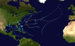
The 2003 Atlantic hurricane season was a very active season with tropical cyclogenesis occurring before and after the official bounds of the season—the first such occurrence since the 1970 season. The season produced 21 tropical cyclones, of which 16 developed into named storms; seven of those attained hurricane status, of which three reached major hurricane status. The strongest hurricane of the season was Hurricane Isabel, which reached Category 5 status on the Saffir–Simpson hurricane scale northeast of the Lesser Antilles; Isabel later struck North Carolina as a Category 2 hurricane, causing $3.6 billion in damage and a total of 51 deaths across the Mid-Atlantic region of the United States.
The 1959 Atlantic hurricane season featured near normal tropical cyclone activity overall. The season officially began on June 15, 1959 and lasted until November 15, 1959. These dates historically described the period in each year when most tropical cyclogenesis occurs in the Atlantic basin. However, the formation of a tropical cyclone is possible at any time of the year, as shown in 1959, by the formation of Tropical Storm Arlene on May 28. Arlene struck Louisiana and brought minor flooding to the Gulf Coast of the United States. The next tropical storm, Beulah, formed in the western Gulf of Mexico and brought negligible impact to Mexico and Texas. Later in June, an unnamed hurricane, caused minor damage in Florida, and then devastated parts of Maritime Canada, resulting in what became known as the Escuminac disaster. Hurricane Cindy brought minor impact to The Carolinas. In late July, Hurricane Debra produced flooding in the state of Texas. Tropical Storm Edith in August and Hurricane Flora in September caused negligible impact on land.

The 1960 Atlantic hurricane season was the least active season since 1952. The season officially began on June 15, and lasted until November 15. These dates conventionally delimit the period of each year when most tropical cyclones form in the Atlantic basin. The first system, an unnamed storm, developed in the Bay of Campeche on June 22. It brought severe local flooding to southeastern Texas and was considered the worst disaster in some towns since a Hurricane in 1945. The unnamed storm moved across the United States for almost a week before dissipating on June 29. In July, Hurricane Abby resulted in minor damage in the Leeward Islands, before impacting a few Central American counties — the remnants of the storm would go on to form Hurricane Celeste in the East Pacific. Later that month, Tropical Storm Brenda caused flooding across much of the East Coast of the United States. The next storm, Hurricane Cleo, caused no known impact, despite its close proximity to land.

The 1970 Atlantic hurricane season officially began on June 1 and lasted until November 30. These dates conventionally delimit the period of each year when most tropical cyclones form in the Atlantic basin. The season was fairly average, with 14 named storms forming, of which seven were hurricanes. Two of those seven became major hurricanes, which are Category 3 or higher on the Saffir–Simpson scale. Also, this was the first season in which reconnaissance aircraft flew into all four quadrants of a tropical cyclone.

The 1985 Atlantic hurricane season had six United States landfalling hurricanes, tied with 1886 and 2020 for the highest number on record. The season officially began on June 1 and lasted until November 30. It was an average season, with 11 named storms developing. This was partially attributed to a La Niña – a meteorological phenomenon that produces favorable conditions across the Atlantic basin, such as lower wind shear and higher sea surface temperatures. The first storm, Ana, developed on July 15 near Bermuda and caused minor effects in Canada while transitioning into an extratropical cyclone. Three other tropical cyclones – Claudette, Henri, and Isabel – did not significantly affect land. Claudette developed offshore of the Southeastern United States and brushed Bermuda and the Azores. Henri and Isabel were dissipating as they approached land. However, the precursor of the latter caused a severe flood in Puerto Rico that killed 180 people. Additionally, Tropical Storm Fabian and three tropical depressions did not have any known impact on land.

The 1989 Atlantic hurricane season was an average hurricane season with 11 named storms. The season officially began on June 1, and ended on November 30. The first tropical cyclone, Tropical Depression One, developed on June 15, and dissipated two days later without any effects on land. Later that month, Tropical Storm Allison caused severe flooding, especially in Texas and Louisiana. Tropical Storm Barry, Tropical Depressions Six, Nine, and Thirteen, and Hurricanes Erin and Felix caused negligible impact. Hurricane Gabrielle and Tropical Storm Iris caused light effects on land, with the former resulting in nine fatalities from rip currents offshore the East Coast of the United States and Atlantic Canada, while the latter produced minor flooding in the United States Virgin Islands.

Hurricane Carla was the most intense tropical cyclone landfall in Texas in the 20th century. The third named storm of the 1961 Atlantic hurricane season, Carla developed from an area of squally weather in the southwestern Caribbean Sea on September 3. As a tropical depression, it strengthened while heading northwest. The system was upgraded to a tropical storm on September 5 and reached hurricane intensity on September 6. On September 7, Carla entered the Gulf of Mexico, passing northeast of the Yucatán Peninsula. On the morning of September 11, Carla became a category 4 hurricane when winds reached 130 mph. Carla made landfall at 2 p.m. on September 11 near Port O'Connor, Texas as a category 4 hurricane with a peak intensity of 145 mph. Traveling inland, the storm was reduced to a tropical storm on September 12 and transitioned into an extratropical cyclone on September 13, while centered over southern Oklahoma. Carla's remnants reached the Labrador Sea, Canada and dissipated on September 17, 1961.

Hurricane Cindy was a tropical cyclone that briefly reached minimal hurricane strength in the Gulf of Mexico during July in the 2005 Atlantic hurricane season and made landfall in Louisiana. It was the third named storm and first hurricane of the season. Cindy was originally thought to have been a tropical storm at peak strength, but was upgraded to a Category 1 hurricane in the post-season analysis. Cindy formed on July 3 just east of the Yucatán Peninsula in the Caribbean Sea. The depression soon made landfall on the peninsula and weakened before reemerging in the Gulf of Mexico on July 4. The storm strengthened as it moved north becoming a hurricane just before making landfall near Grand Isle, Louisiana, on July 5. The storm weakened as it moved overland and became extratropical on July 7.

Hurricane Chantal was one of three tropical cyclones to make landfall in Texas during the 1989 Atlantic hurricane season. The third named storm and the first hurricane of the season, Chantal slowly developed on July 30 in the southern Gulf of Mexico from a tropical disturbance that was previously within Intertropical Convergence Zone (ITCZ) while near Trinidad and Tobago. While heading north-northwestward, the depression steadily intensified and was upgraded to Tropical Storm Chantal on the following day. Thereafter, Chantal quickly strengthen and became a hurricane on August 1. After intensifying slightly further, Chantal made landfall near High Island, Texas later that day. The storm quickly weakened upon moving inland and fell to tropical storm intensity a few hours after landfall. Early on August 2, Chantal weakened to a tropical depression and dissipated over Oklahoma by August 4.

Tropical Storm Chris caused minor flooding along the Gulf Coast of the United States in September 1982. The fifth tropical or subtropical cyclone and third named storm of the 1982 Atlantic hurricane season, Chris developed from a surface low-pressure area in the northern Gulf of Mexico on September 9. Although initially displaying subtropical characteristics, the low pressure area gradually acquired tropical characteristics, and was reclassified as Tropical Depression Four within 24 hours of development. The depression then began to intensify and was upgraded to Tropical Storm Chris on September 10. Thereafter, the storm turned north-north-eastward and strengthened further. On September 11, Chris peaked as a 65 mph (100 km/h) tropical storm. Later that day, it made landfall near Sabine Pass, Port Arthur, Texas. By September 13, Chris dissipated over Arkansas.

Tropical Depression Ten was a short-lived tropical cyclone that made landfall on the Florida Panhandle in September 2007. The system developed as a subtropical depression on September 21 in the northeastern Gulf of Mexico from the interaction of a tropical wave, the tail end of a cold front, and an upper-level low. Initially containing a poorly defined circulation and intermittent thunderstorm activity, the system transitioned into a tropical depression after convection increased over the center. Tracking northwestward, the depression moved ashore near Fort Walton Beach early on September 22 and dissipated over southeastern Alabama shortly thereafter.

Hurricane Bonnie caused moderate damage along the Gulf Coast of the United States in late June 1986. The second named storm and first hurricane of the 1986 Atlantic hurricane season, Bonnie developed out of an area of low pressure over the central Gulf of Mexico on June 23. The system gradually intensified and was declared Tropical Storm Bonnie the next day as it moved generally towards the west-northwest. On June 25, Bonnie was upgraded to a hurricane. Bonnie strengthened further and on the following day, the storm attained its peak intensity with maximum sustained winds of 85 mph (137 km/h). Shortly thereafter, Bonnie made landfall near High Island, Texas. Following landfall, Bonnie quickly weakened below tropical storm status and dissipated over Missouri on June 28.

Tropical Storm Candy produced minor impact in the state of Texas during the 1968 Atlantic hurricane season. The third tropical cyclone of the annual season, it developed from a tropical disturbance in the southwestern Gulf of Mexico on June 22. Gradual strengthening occurred, with the depression becoming Tropical Storm Candy on the following day. The storm reached its peak intensity of 70 mph (110 km/h) later that day and made landfall Port Aransas, Texas on June 23. Candy weakened into a tropical depression only hours after moving inland. However, the system remained a designated cyclone until June 26, at which time it completed extratropical transition over the state of Michigan.


