
The 1995 Atlantic hurricane season was a very active Atlantic hurricane season, and is considered to be the start of an ongoing era of high-activity tropical cyclone formation. The season produced twenty-one tropical cyclones, nineteen named storms, as well as eleven hurricanes and five major hurricanes. The season officially began on June 1 and ended on November 30, dates which conventionally delimit the period of each year when most tropical cyclones develop in the Atlantic basin. The first tropical cyclone, Hurricane Allison, developed on June 2, while the season's final storm, Hurricane Tanya, transitioned into an extratropical cyclone on November 1. The very active Atlantic hurricane activity in 1995 was caused by La Niña conditions, which also influenced an inactive Pacific hurricane season. It was tied with 1887 Atlantic hurricane season with 19 named storms, which was later equalled by the 2010, 2011, and 2012 seasons.

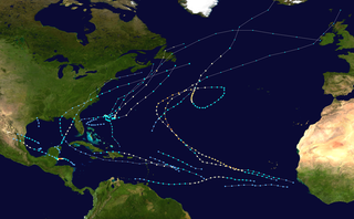
The 2003 Atlantic hurricane season was a very active season with tropical cyclogenesis occurring before and after the official bounds of the season—the first such occurrence since the 1970 season. The season produced 21 tropical cyclones, of which 16 developed into named storms; seven of those attained hurricane status, of which three reached major hurricane status. The strongest hurricane of the season was Hurricane Isabel, which reached Category 5 status on the Saffir–Simpson hurricane scale northeast of the Lesser Antilles; Isabel later struck North Carolina as a Category 2 hurricane, causing $3.6 billion in damage and a total of 51 deaths across the Mid-Atlantic region of the United States.

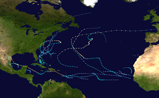
The 2002 Atlantic hurricane season was a near-average Atlantic hurricane season. It officially started on June 1, 2002, and ended on November 30, dates which conventionally limit the period of each year when most tropical cyclones develop in the Atlantic Ocean. The season produced fourteen tropical cyclones, of which twelve developed into named storms; four became hurricanes, and two attained major hurricane status. While the season's first cyclone did not develop until July 14, activity quickly picked up: eight storms developed in the month of September. It ended early however, with no tropical storms forming after October 6—a rare occurrence caused partly by El Niño conditions. The most intense hurricane of the season was Hurricane Isidore, a Category 3 storm with a minimum central pressure of 934 mbar; however, Hurricane Lili, with a minimum pressure of 938 mbar, attained higher winds and peaked at Category 4.

The 2001 Atlantic hurricane season was a fairly active Atlantic hurricane season that produced 17 tropical cyclones, 15 named storms, nine hurricanes, and four major hurricanes. The season officially lasted from June 1, 2001, to November 30, 2001, dates which by convention limit the period of each year when tropical cyclones tend to form in the Atlantic Ocean basin. The season began with Tropical Storm Allison on June 4, and ended with Hurricane Olga, which dissipated on December 6.
The 2000 Atlantic hurricane season was a fairly active hurricane season, but featured the latest first named storm in a hurricane season since 1992. The hurricane season officially began on June 1, and ended on November 30. It was slightly above average due to a La Niña weather pattern although most of the storms were weak. It was also the only season to have two of the storms affect Ireland. The first cyclone, Tropical Depression One, developed in the southern Gulf of Mexico on June 7 and dissipated after an uneventful duration. However, it would be almost two months before the first named storm, Alberto, formed near Cape Verde; Alberto also dissipated with no effects on land. Several other tropical cyclones—Tropical Depression Two, Tropical Depression Four, Chris, Ernesto, Nadine, and an unnamed subtropical storm—did not impact land. Five additional storms—Tropical Depression Nine, Florence, Isaac, Joyce, and Leslie—minimally affected land areas.
The 1967 Atlantic hurricane season was an active Atlantic hurricane season overall, producing 13 nameable storms, of which 6 strengthened into hurricanes. The season officially began on June 1, 1967, and lasted until November 30, 1967. These dates, adopted by convention, historically describe the period in each year when most tropical cyclogenesis occurs in the Atlantic Ocean. The season's first system, Tropical Depression One, formed on June 10, and the last, Tropical Storm Heidi, lost tropical characteristics on November 2.

The 1991 Atlantic hurricane season was the first season since 1984 in which no hurricanes developed from tropical waves, which are the source for most North Atlantic tropical cyclones. The hurricane season officially began on June 1, and ended on November 30. It was the least active in four years due to higher than usual wind shear across the Atlantic Ocean. The first storm, Ana, developed on July 2 off the southeast United States and dissipated without causing significant effects. Two other tropical storms in the season – Danny and Erika – did not significantly affect land. Danny dissipated east of the Lesser Antilles, and Erika passed through the Azores before becoming extratropical. In addition, there were four non-developing tropical depressions. The second depression of the season struck Mexico with significant accompanying rains.

The 2006 Atlantic hurricane season was the least active in the basin since 1997, with nine named storms as well as an additional unnamed tropical storm identified by the National Hurricane Center. 2006 was the first season since 2001 in which no hurricanes made landfall in the United States, and was the first since 1994 in which no tropical cyclones formed during October. Following the intense activity of 2003, 2004, and 2005, forecasters predicted that the 2006 season would be only slightly less active. Instead, it turned out to be a below average season, as activity was slowed by a rapidly forming moderate El Niño event, the presence of the Saharan Air Layer over the tropical Atlantic, and the steady presence of a robust secondary high-pressure area to the Azores High centered on Bermuda. There were no tropical cyclones after October 2.

Tropical Storm Ana was the first named storm of the 2003 Atlantic hurricane season. A pre-season storm, it developed initially as a subtropical cyclone from a non-tropical low on April 20 to the west of Bermuda. It tracked east-southeastward and organized, and on April 21 it transitioned into a tropical cyclone with peak winds of 60 mph (97 km/h). Tropical Storm Ana turned east-northeastward, steadily weakening due to wind shear and an approaching cold front, and on April 24 it became an extratropical cyclone. The storm brushed Bermuda with light rain, and its remnants produced precipitation in the Azores and the United Kingdom. Swells generated by the storm capsized a boat along the Florida coastline, causing two fatalities.

Hurricane Gabrielle was a North Atlantic hurricane that caused flooding in both Florida and Newfoundland in September 2001. It developed in the Gulf of Mexico on the same day as the September 11 attacks; after the attacks, flights were canceled nationwide for two days, and when Gabrielle struck Florida on September 14, it caused a day of additional cancellations. The storm moved ashore with winds of 70 mph (110 km/h) near Venice, a city located south of the Tampa Bay area. The combination of the winds and heavy rainfall, which peaked at 15.1 in (380 mm) in Parrish, left 570,000 customers without power along the west coast and 126,000 customers without power on the east coast. The storm caused about $230 million (2001 USD) in damage in Florida. In the Gulf of Mexico, high waves contributed to two deaths, one of which was indirect; there was also a death due to flooding in Winter Haven.

Tropical Storm Alberto was the first tropical storm of the 2006 Atlantic hurricane season. Forming on June 10 in the northwestern Caribbean, the storm moved generally to the north, reaching a maximum intensity of 70 mph (110 km/h) before weakening and moving ashore in the Big Bend area of Florida on June 13. Alberto then moved through eastern Georgia, North Carolina, and Virginia as a tropical depression before becoming extratropical on June 14.

Hurricane Kyle was the fifth-longest-lived Atlantic tropical or subtropical cyclone on record. The eleventh named storm and third hurricane of the 2002 Atlantic hurricane season, Kyle developed as a subtropical cyclone on September 20 to the east-southeast of Bermuda. Looping westward, it transitioned into a tropical cyclone and became a hurricane on September 25. For the next two weeks, Kyle tracked generally westward, oscillating in strength several times because of fluctuations in environmental conditions. On October 11, the cyclone turned northeastward and made landfalls near Charleston, South Carolina, and Long Beach, North Carolina, at tropical storm status. After lasting as a cyclone for 22 days, Kyle dissipated on October 12 as it was absorbed by an approaching cold front.

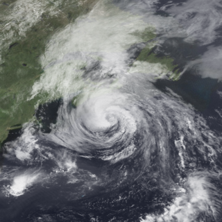
Hurricane Florence was the first North Atlantic hurricane to produce hurricane-force winds on the island of Bermuda since Hurricane Fabian in September 2003. The seventh tropical storm and second hurricane of the 2006 Atlantic hurricane season, Florence developed from a tropical wave in the eastern Atlantic Ocean on September 3. Due to unfavorable conditions, the system failed to organize initially, and as a result, the storm grew to an unusually large size. After several days, Florence encountered an area of lesser wind shear and intensified into a hurricane on September 10. It passed just west of Bermuda while recurving northeastward, and on September 13 it transitioned into an extratropical cyclone.

Tropical Storm Dean was a strong tropical storm that affected at least twelve islands along its path from the tropical Atlantic Ocean to east of Atlantic Canada in August 2001. Dean developed from a tropical wave on August 22 over the Lesser Antilles, and was initially predicted to intensify further to reach hurricane status. However, strong wind shear quickly weakened Dean to cause it to dissipate on August 23. The remnants turned northward, and redeveloped on August 26 to the north of Bermuda. Located over warm waters and in an area of favorable conditions, Dean steadily strengthened while moving to the northeast, and peaked just below hurricane status on August 27 about 465 miles (748 km) southwest of Newfoundland. The storm subsequently weakened over cooler waters, and became extratropical on August 28.

Hurricane Erin was the longest-lived hurricane in the 2001 Atlantic hurricane season. The sixth tropical depression, fifth tropical storm, and first hurricane of the season, Erin developed from a tropical wave on September 1. After strengthening to a 60 mph (97 km/h) tropical storm as it moved to the west-northwest, wind shear weakened Erin and caused it to degenerate into a remnant low on September 5. The remnants re-organized into a tropical depression the next day, and Erin strengthened into a hurricane on September 9 while moving northwestward. This was the latest date for the first hurricane of the season since Hurricane Diana on September 10, 1984. Erin quickly intensified and reached peak winds of 120 mph (190 km/h) later on September 9. At its closest approach, Erin passed 105 miles (169 km) east-northeast of Bermuda near peak intensity, and subsequently weakened as it turned to the east. A trough turned Erin to the northeast, and after passing just east of Cape Race, Newfoundland it became extratropical on September 15. The extratropical remnant continued northeastward and was absorbed into another extratropical storm near Greenland on September 17.
Hurricane Bertha caused minor damage in the United States, Bermuda, and Atlantic Canada in July and August 1990. The third tropical cyclone, second named storm, and first hurricane of the 1990 Atlantic hurricane season, Bertha developed from a frontal low pressure area offshore of North Carolina on July 24. Initially subtropical, it slowly acquired tropical characteristics while tracked southeast and then southwestward. By early on July 27, the cyclone was re-classified as a tropical depression. Following its transition, the depression intensified and was upgraded to Tropical Storm Bertha on July 28. The storm then curved northeastward and rapidly strengthened. Bertha became a hurricane early on July 29, though it weakened back to a tropical storm later that day. On the following day, Bertha re-intensified into a hurricane and peaked as an 80 mph (130 km/h) Category 1 hurricane on July 31.

Hurricane Isaac was a large and powerful Cape Verde hurricane that lasted through late September and early October 2000. The thirteenth tropical cyclone, ninth named storm, and the fifth hurricane of 2000 Atlantic hurricane season, Isaac developed from a tropical wave south of Cape Verde on September 21. The depression intensified, and on the following day, it was upgraded to Tropical Storm Isaac. Due to conductive atmospheric conditions, Isaac continued to strengthen, and attained hurricane intensity on September 23. Isaac managed to become a Category 3 hurricane on September 24, before steadily weakening shortly thereafter. By September 26, the storm had deteriorated to a Category 1 hurricane. However, it again encountered favorable conditions, which caused Isaac to re-intensify.

Hurricane Florence attained Category 1 intensity on three separate occasions in mid-September 2000. The tenth tropical cyclone, sixth named storm, and third hurricane of the 2000 Atlantic hurricane season, Florence developed on September 10 from a cold front to the southwest of Bermuda. Initially a subtropical cyclone, it quickly organized, attaining hurricane status twice in a two-day period before weakening while remaining nearly stationary. Florence accelerated northeastward, reaching peak winds as a hurricane after passing near Bermuda. On September 17, the storm was absorbed by a larger extratropical cyclone. Hurricane Florence threatened Bermuda during its third time at hurricane intensity, bringing tropical storm force winds to the island but causing no reported damage. However, three deaths in North Carolina were blamed on rip currents triggered by the hurricane on September 12.

Hurricane Ella was the strongest hurricane on record in Canadian waters. It formed on August 30, 1978 to the south of Bermuda, and quickly intensified as it tracked west-northwestward. By September 1, Ella reached winds of 125 mph (201 km/h), and it was expected to pass close to the Outer Banks of North Carolina during the busy Labor Day Weekend. The hurricane became stationary for about 24 hours, and later turned to the northeast away from the coast. On September 4, Ella reached Category 4 status on the Saffir-Simpson Hurricane Scale off the coast of Nova Scotia. It subsequently weakened, passing southeast of Newfoundland before being absorbed by a large extratropical cyclone.

Hurricane Chris was a moderately strong tropical cyclone that affected the East Coast of the United States and Atlantic Canada in July 2018. The third tropical or subtropical cyclone, third named storm, and second hurricane of the 2018 Atlantic hurricane season, Chris originated from a frontal system that moved offshore the coast of the northeastern United States on June 29. The front evolved into a non-tropical low by July 3. After further organization, a tropical depression formed on July 6, several hundred miles south-southeast of Cape Hatteras, North Carolina. Two days later, the depression strengthened into a tropical storm and received the name Chris. Chris slowly strengthened as it drifted into warmer waters. These favorable conditions allowed Chris to rapidly intensify into a hurricane on July 10. The hurricane reached its peak intensity with winds of 105 mph (165 km/h) and a pressure of 969 mbar (28.61 inHg) at. This peak intensity was short-lived though, as Chris began to undergo extratropical transition. At 12:00 UTC on July 12, Chris became an extratropical cyclone well southeast of Newfoundland. The low continued northeastward over the Atlantic for the next few days, before weakening and finally dissipating southeast of Iceland on July 17.


