Tropical Storm Erin (2007)

Last updated
Map key
  Tropical depression (≤38 mph, ≤62 km/h)
  Tropical storm (39–73 mph, 63–118 km/h)
  Category 1 (74–95 mph, 119–153 km/h)
  Category 2 (96–110 mph, 154–177 km/h)
  Category 3 (111–129 mph, 178–208 km/h)
  Category 4 (130–156 mph, 209–251 km/h)
  Category 5 (≥157 mph, ≥252 km/h)
  Unknown
Storm type
Disc Plain black.svg Tropical cyclone
Solid black.svg Subtropical cyclone
ArrowUp.svg Extratropical cyclone, remnant low, tropical disturbance, or monsoon depression

On August 1, 2007, an area of convection developed just south of Jamaica in association with a trough of low pressure. [3] The system tracked west-northwestward, and by August 10 consisted of a broad surface trough with minimal shower activity. [4] Convection increased on August 11, [5] and by August 12 the interaction between a tropical wave and an upper-level low in the area resulted in a large area of disorganized thunderstorms extending from the western Caribbean Sea into the central Bahamas. [6] Upper-level winds gradually became more beneficial for development, and on August 13 a broad low pressure area formed about 90 miles (140 km) north-northeast of Cancún, Quintana Roo, Mexico. [7] Late on August 14, a Hurricane Hunters flight into the system reported a small circulation center, but at the time was not well-defined enough to result in the initiation of tropical cyclone advisories. However, deep convection was maintained near the increasingly organizing center, and at 0300  UTC on August 15 the National Hurricane Center classified it as Tropical Depression Five about 425 miles (684 km) southeast of Brownsville, Texas. [8]

In the overnight hours after formation, the storm was disorganized with a ragged and ill-defined center of circulation. Located to the south of a mid to upper-level ridge over the southern United States, the system tracked to the west-northwest through an environment conducive for further strengthening; an upper-level anticyclone developed over the central Gulf of Mexico, and sea surface temperatures along its track were warm. [9] The cloud pattern became better organized, maintaining a large area of convection with curved rainbands and well-established outflow. [10] Based on reports from Hurricane Hunters, the National Hurricane Center upgraded the depression to Tropical Storm Erin at 1530 UTC on August 15 about 250 miles (400 km) east of Brownsville, Texas. [11] As it continued northwestward, Erin remained disorganized and failed to strengthen beyond minimal tropical storm status. [12] At 1200 UTC on August 16 the cyclone made landfall near Lamar, Texas as it weakened to tropical depression status. [13] Three hours later, the National Hurricane Center ceased issuing advisories on Erin as warning responsibility was transferred to the Hydrometeorological Prediction Center. [14]

The remnants of Erin over Oklahoma, with what appears to be an eye-like structure Tropical Depression Erin inland over OK.png
The remnants of Erin over Oklahoma, with what appears to be an eye-like structure

Drifting northwestward through Texas, Tropical Depression Erin maintained an area of convection near the center, with its widespread but scattered rainbands dropping moderate to heavy precipitation. By August 17, the winds decreased to 20 mph (32 km/h), [15] with higher gusts. The system turned to the north-northeast on August 18, while heavy bands of thunderstorms continued to rotate around the center of Erin. [16] Early on August 19 after entering Oklahoma, the remnants of Erin suddenly re-intensified to maximum sustained winds of 60 mph (97 km/h) a short distance west of Oklahoma City. [17] [18] The Norman, Oklahoma National Weather Service remarked the intensification "[resulted] in what amounts to an inland tropical storm;" [19] at 0930 UTC the system presented an eye-like feature and a spiral rainband, and produced wind gusts of over 80 mph (130 km/h). [20] However, a few hours later, the depression began weakening again, [21] and late on August 19 Erin weakened significantly as the circulation dissipated over northeastern Oklahoma. Despite displaying tropical characteristics, the National Hurricane Center determined the system was not a tropical cyclone over Oklahoma, and classified it as a "low". [22] The low continued into southeastern Kansas before dissipating, feeding moisture northward toward a frontal system extending from the Midwestern United States through the Mid-Atlantic States. [23] Its remnant mid-level circulation then moved eastward across Missouri, Kentucky, and Virginia before losing identity as it moved out into the Atlantic Ocean.

Preparations

Tropical Storm Erin
Erin 15 aug 2007 1940Z.jpg
Tropical Storm Erin near landfall
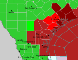
Weather alerts as Tropical Storm Erin made landfall in Texas
Weather alerts as Tropical Storm Erin makes landfall in Texas TSErin2007Severealerts.PNG
Weather alerts as Tropical Storm Erin makes landfall in Texas
  Tornado Warning   Flash Flood Warning
 Inland Tropical Storm Warning  Tropical Storm Warning
 Flood Warning Flash Flood Watch
 Small Craft Advisory

Immediately upon becoming a tropical cyclone, the National Hurricane Center issued a tropical storm watch from Freeport, Texas to the United States/Mexico border; at the same time, the government of Mexico issued a tropical storm watch southward to Rio San Fernando. [24] Shortly before attaining tropical storm status, the watch in Texas was upgraded to a tropical storm warning. [25] Late on August 15, the warning was extended to San Luis Pass, while the watch in Mexico was discontinued. [26] As Erin made landfall, the warning was canceled, [13] and several flood watches and warnings were issued for counties across southeastern Texas. [27] Upon moving into Oklahoma, flood and flash flood warnings were issued for several counties. [21]

Governor Rick Perry activated the National Guard and mobilized emergency personnel to the region expected to be affected by the storm. [28] Erin was expected to bring flooding to the region, which had already been declared a disaster area on August 7, 2007, due to widespread flooding on the Nueces River basin; [29] this area remained flooded as of August 15, 2007. [30] On August 15, oil futures rose to $74.01 (USD), due to fears of Erin disrupting oil supplies produced on Texan coasts, combined with low oil inventories. [31] As a result of the threat from the storm, Shell Oil Company evacuated 188 workers on oil platforms in the northwestern Gulf of Mexico. [32]

Impact

Texas

Erin Storm Total Rainfall Erin 2007 rainfall.gif
Erin Storm Total Rainfall

By midday on August 15, rainbands with gusty winds began affecting the Texas coastline. [11] As it moved ashore, the storm produced heavy rainfall near and to the or northeast of its path, reaching 11.02 inches (280 mm) at a station in Lockwood. [21] The storm caused several bayous in the Houston area to reach or exceed flood levels. [33] Across southeastern Texas, the cyclone spawned several funnel clouds, [34] and near IAH an EF0 tornado was reported. Wind gusts from Erin were minor across the state, peaking at 35 mph (56 km/h) at Palacios with an unofficial report of 39 mph (63 km/h) at Jamaica Beach. Upon moving ashore, the storm produced a minor storm surge peaking at 3.22 feet (0.98 m) at Pleasure Pier, which caused minor beach erosion. [35]

In Clear Lake City, heavy rainfall collapsed a portion of a grocery store roof, killing one worker and one Coca-Cola merchandiser. The precipitation caused moderate flooding across eastern portions of Harris County; over 400 homes and 40 businesses were flooded. [35] Flooding across the Greater Houston area briefly halted the METRORail and closed several state roads. One person drowned after driving into a retention pond. [36] Several people required rescue assistance, [33] and in Comal County a car accident caused three fatalities. [37] The passage of the storm temporarily left about 20,000 electrical customers without power, though most outages were quickly restored. [33] In San Antonio, one body was recovered from a creek and another died after driving into a flooded road and was swept into a drainage ditch in which four others survived. In Sisterdale, two people were killed when they were swept away stalled over Sister Creek. [38] In Taylor County, near Abilene, flooding killed one person and forced the evacuation of about 2,000 people. [39] Damage in Texas totaled over $45 million (2007 USD). [40] [41] [42]

Oklahoma

Caddo County, OK, August 20, 2007 - This nursing home was damaged by high winds from Tropical Storm Erin. FEMA - 31827 - Aerial of damaged nursing home.jpg
Caddo County, OK, August 20, 2007 This nursing home was damaged by high winds from Tropical Storm Erin.

After its unexpected redevelopment over Oklahoma, widespread damage was also reported there. Several communities in central Oklahoma were flooded due to the heavy rainfall. Watonga, Kingfisher and Geary were the hardest-hit communities, where many houses and buildings were inundated. The weather forced the cancellation of the Hydro Fair as the carnival rides were not safe in heavy rain and high wind. Winds in Watonga gusted as high as 82 mph (132 km/h), which damaged numerous trees and power lines and heavily damaged mobile homes. The entire community lost power, as did about 15,000 customers in total in the Oklahoma City metropolitan area. A section of Interstate 40 was also closed for a while. [43]

One person drowned in a cellar in Fort Cobb, and another drowned in Kingfisher. [44] Another storm-related death took place in Seminole. [45] Three others were found dead after a weather-related automobile accident also near Carnegie. [46] Another automobile accident fatality took place in Okmulgee County but it is unclear if the event was storm-related. [47] Damage amounted to over $2 million (2007 USD). [48] [49]

Missouri

Although its surface circulation had dissipated, its circulation aloft remained intact and led to a burst of rainfall early on August 20. The 11.94 inches/303.3 mm that fell at Miller became the wettest Missouri rainfall total associated with a tropical cyclone, or its remains, since at least 1972. [17] [50] One person died in Sleeper when he drove into flood waters which had swept away a bridge he was attempting to navigate onto. [51] Nine water rescues occurred along the I-44 corridor, mostly caused by Erin's rainfall. [52] Damage totaled about $19.8 million (2007 USD) in the state, primarily in Polk County. [53] [54] [55] [56] [57]

See also

Related Research Articles

<span class="mw-page-title-main">Tropical Storm Allison</span> Atlantic tropical storm in 2001

Tropical Storm Allison was a tropical storm that devastated southeast Texas in June of the 2001 Atlantic hurricane season. An arguable example of the "brown ocean effect", Allison lasted unusually long for a June storm, remaining tropical or subtropical for 16 days, most of which was when the storm was over land dumping torrential rainfall. The storm developed from a tropical wave in the northern Gulf of Mexico on June 4, 2001, and struck the upper Texas coast shortly thereafter. It drifted northward through the state, turned back to the south, and re-entered the Gulf of Mexico. The storm continued to the east-northeast, made landfall on Louisiana, then moved across the southeast United States and Mid-Atlantic. Allison was the first storm since Tropical Storm Frances in 1998 to strike the northern Texas coastline.

<span class="mw-page-title-main">2003 Atlantic hurricane season</span>

The 2003 Atlantic hurricane season was a very active season with tropical cyclogenesis occurring before and after the official bounds of the season—the first such occurrence since the 1970 season. The season produced 21 tropical cyclones, of which 16 developed into named storms; seven of those attained hurricane status, of which three reached major hurricane status. The strongest hurricane of the season was Hurricane Isabel, which reached Category 5 status on the Saffir–Simpson hurricane scale northeast of the Lesser Antilles; Isabel later struck North Carolina as a Category 2 hurricane, causing $3.6 billion in damage and a total of 51 deaths across the Mid-Atlantic region of the United States.

<span class="mw-page-title-main">2002 Atlantic hurricane season</span>

The 2002 Atlantic hurricane season was a near-average Atlantic hurricane season. It officially started on June 1, 2002, and ended on November 30, dates which conventionally limit the period of each year when most tropical cyclones develop in the Atlantic Ocean. The season produced fourteen tropical cyclones, of which twelve developed into named storms; four became hurricanes, and two attained major hurricane status. While the season's first cyclone did not develop until July 14, activity quickly picked up: eight storms developed in the month of September. It ended early however, with no tropical storms forming after October 6—a rare occurrence caused partly by El Niño conditions. The most intense hurricane of the season was Hurricane Isidore with a minimum central pressure of 934 mbar, although Hurricane Lili attained higher winds and peaked at Category 4 whereas Isidore only reached Category 3. However, Lili had a minimum central pressure of 938 mbar.

<span class="mw-page-title-main">1998 Pacific hurricane season</span>

The 1998 Pacific hurricane season was a fairly average Pacific hurricane season. Despite this, it had nine hurricanes and six major hurricanes, which was well above average. The season officially started on May 15 in the eastern Pacific and on June 1 in the central Pacific, and ended on November 30; these dates conventionally delimit the period during which most tropical cyclones form in that region. The first tropical cyclone developed on June 11, about ten days later than the normal start of the season. The final storm of the year, Hurricane Madeline, dissipated on October 20. Storm activity in the Central Pacific Hurricane Center's warning zone was low, with just one tropical depression observed in the region. Two tropical cyclones from the eastern Pacific also entered the central Pacific; the former did so as a hurricane.

<span class="mw-page-title-main">2007 Atlantic hurricane season</span>

The 2007 Atlantic hurricane season was the first season since 2003 to feature tropical activity both before and after the official bounds of the season. There were an above-average number of named storms during the season – 15, however many storms were weak and short-lived. Despite the predominance of weak systems, this was the first season on record to feature more than one Category 5 landfalling hurricane. This would not happen again until 2017. It produced 17 tropical cyclones, 15 tropical storms, six hurricanes, and two major hurricanes. It officially started on June 1 and ended on November 30, dates which conventionally delimit the period during which most tropical cyclones form in the Atlantic Ocean, although as shown by Subtropical Storm Andrea and Tropical Storm Olga in early May and early December, respectively, the formation of tropical cyclones is possible at any time of the year. The first system, Subtropical Storm Andrea, developed on May 9, while the last storm, Tropical Storm Olga, dissipated on December 13. The most intense hurricane, Dean, was, at the time, the third most intense landfalling Atlantic storm on record. It was the second on record in which an Atlantic hurricane, Felix, and an eastern Pacific hurricane, Henriette, made landfall on the same day. September had a then record-tying eight storms, until it was surpassed in 2020. However, the strengths and durations of most of the storms were low.

<span class="mw-page-title-main">Tropical Storm Barry (2001)</span> Atlantic tropical cyclone

Tropical Storm Barry was a strong tropical storm that made landfall on the Florida Panhandle during August 2001. The third tropical cyclone and second named storm of the 2001 Atlantic hurricane season, Barry developed from a tropical wave that moved off the coast of Africa on July 24. The wave entered the Caribbean on July 29 and spawned a low-pressure area, which organized into Tropical Storm Barry on August 3. After fluctuations in intensity and track, the storm attained peak winds of 70 mph (110 km/h) over the Gulf of Mexico. Barry headed northward and moved ashore along the Gulf Coast before degenerating into a remnant low on August 7. On the next day, Barry's remnants dissipated over Missouri.

<span class="mw-page-title-main">Tropical Storm Helene (2000)</span> Atlantic tropical storm in 2000

Tropical Storm Helene was a long-lived tropical cyclone that oscillated for ten days between a tropical wave and a 70 mph (110 km/h) tropical storm. It was the twelfth tropical cyclone and eighth tropical storm of the 2000 Atlantic hurricane season, forming on September 15 east of the Windward Islands. After degenerating into a tropical wave, the system produced flooding and mudslides in Puerto Rico. It reformed into a tropical depression on September 19 south of Cuba, and crossed the western portion of the island the next day while on the verge of dissipation. However, it intensified into a tropical storm in the Gulf of Mexico, reaching its peak intensity while approaching the northern Gulf Coast.

<span class="mw-page-title-main">Hurricane Kyle (2002)</span> Category 1 Atlantic hurricane in 2002

Hurricane Kyle was the fifth-longest-lived Atlantic tropical or subtropical cyclone on record. The eleventh named storm and third hurricane of the 2002 Atlantic hurricane season, Kyle developed as a subtropical cyclone on September 20 to the east-southeast of Bermuda. Looping westward, it transitioned into a tropical cyclone and became a hurricane on September 25. For the next two weeks, Kyle tracked generally westward, oscillating in strength several times because of fluctuations in environmental conditions. On October 11, the cyclone turned northeastward and made landfalls near Charleston, South Carolina, and Long Beach, North Carolina, at tropical storm status. After lasting as a cyclone for 22 days, Kyle dissipated on October 12 as it was absorbed by an approaching cold front.

<span class="mw-page-title-main">Tropical Storm Beryl (2000)</span> Atlantic tropical storm in 2000

Tropical Storm Beryl made landfall just south of the Mexico–United States border in mid-August 2000, causing minimal damage. The second named storm of the 2000 Atlantic hurricane season, Beryl originated from a tropical wave near the African coastline. Tracking westward, the wave failed to organize substantially until entering the Bay of Campeche, at which time it developed into a tropical storm. Beryl rapidly deepened while in the Gulf of Mexico, and it initially was forecast to strengthen to a hurricane under favorable conditions for development. Instead, Beryl remained at moderate tropical storm intensity and failed to intensify any further. It made landfall in the Mexican state of Tamaulipas as a weak tropical storm with winds of 50 mph (80 km/h) on August 15, 2000 and dissipated over mountainous terrain shortly thereafter. One death was reported in Mexico due to drowning. Otherwise, no significant damage was reported associated with Beryl, as it affected a sparsely populated area of Mexico.

<span class="mw-page-title-main">Tropical Storm Hermine (1998)</span> Atlantic tropical cyclone

Tropical Storm Hermine was the eighth tropical cyclone and named storm of the 1998 Atlantic hurricane season. Hermine developed from a tropical wave that emerged from the west coast of Africa on September 5. The wave moved westward across the Atlantic Ocean, and on entering the northwest Caribbean interacted with other weather systems. The resultant system was declared a tropical depression on September 17 in the central Gulf of Mexico. The storm meandered north slowly, and after being upgraded to a tropical storm made landfall on Louisiana, where it quickly deteriorated into a tropical depression again on September 20.

<span class="mw-page-title-main">Tropical Storm Barry (2007)</span> Atlantic tropical cyclone

Tropical Storm Barry was a rapidly forming tropical cyclone that made landfall on Florida, United States, in early June 2007. The second named storm of the 2007 Atlantic hurricane season, Barry developed from a trough of low pressure in the southeastern Gulf of Mexico on June 1. It tracked rapidly northeastward, reaching peak winds of 60 mph (97 km/h) before weakening and making landfall near Tampa Bay as a tropical depression. Barry quickly lost tropical characteristics after wind shear removed much of the convection, and early on June 3, it completed the transition into an extratropical cyclone. The extratropical remnants tracked up the East Coast of the United States, and were absorbed by a larger extratropical cyclone on June 5.

<span class="mw-page-title-main">Hurricane Humberto (2007)</span> Category 1 Atlantic hurricane in 2007

Hurricane Humberto was a Category 1 hurricane that formed and intensified faster than any other North Atlantic tropical cyclone on record, before landfall. The eighth named storm and third hurricane of the 2007 Atlantic hurricane season, Humberto developed on September 12, 2007, in the northwestern Gulf of Mexico. The tropical cyclone rapidly strengthened and struck High Island, Texas, with winds of about 90 mph (140 km/h) early on September 13. It steadily weakened after moving ashore, and on September 14, Humberto began dissipating over northwestern Georgia as it interacted with an approaching cold front.

<span class="mw-page-title-main">Tropical Depression Ten (2007)</span> Atlantic tropical cyclone

Tropical Depression Ten was a short-lived tropical cyclone that made landfall on the Florida Panhandle in September 2007. The system developed as a subtropical depression on September 21 in the northeastern Gulf of Mexico from the interaction of a tropical wave, the tail end of a cold front, and an upper-level low. Initially containing a poorly defined circulation and intermittent thunderstorm activity, the system transitioned into a tropical depression after convection increased over the center. Tracking northwestward, the depression moved ashore near Fort Walton Beach early on September 22 and dissipated over southeastern Alabama shortly thereafter.

<span class="mw-page-title-main">Tropical Depression Two (2010)</span> Atlantic tropical depression in 2010

Tropical Depression Two was a short-lived tropical cyclone that impacted portions of Texas and Mexico during the highly active 2010 Atlantic hurricane season. It formed from a tropical wave that emerged off the western coast of Africa and crossed the Atlantic Ocean without any development. Upon entering the western Gulf of Mexico, the depression encountered a conducive environment for tropical cyclogenesis, and was designated Tropical Depression Two at 0600 UTC on July 8. Intensification into a tropical storm was initially anticipated by the National Hurricane Center (NHC), but due to its proximity to land, the depression failed to attain the status. It made landfall on South Padre Island, Texas before degenerating into a remnant low on July 9, and dissipating the following day. Due to the system's weak intensity, there were no reports of damage inflicted by winds across Texas or Mexico, although the cyclone did bring minimal rainfall totals to northern Mexico, an area severely affected by Hurricane Alex just one week previous.

References

  1. Clark Evans; Russ S. Schumacher; Thomas J. Galarneau Jr (2011). "Sensitivity in the Overland Reintensification of Tropical Cyclone Erin (2007) to Near-Surface Soil Moisture Characteristics". Monthly Weather Review. 139 (12): 3848–3870. Bibcode:2011MWRv..139.3848E. doi: 10.1175/2011MWR3593.1 .
  2. Jeff Masters; Bob Henson (15 June 2015). "Dangerous Flood Potential in Texas, Oklahoma from Invest 91L". Archived from the original on 15 June 2015. Retrieved 15 June 2015.
  3. Beven (2007). "August 9 Tropical Weather Outlook". National Hurricane Center. Retrieved 2007-08-14.[ permanent dead link ]
  4. Beven (2007). "August 10 Tropical Weather Outlook". National Hurricane Center. Retrieved 2007-08-14.[ permanent dead link ]
  5. Rhome (2007). "August 11 Tropical Weather Outlook". National Hurricane Center. Retrieved 2007-08-14.[ permanent dead link ]
  6. Blake (2007). "August 12 Tropical Weather Outlook". National Hurricane Center. Retrieved 2007-08-14.[ permanent dead link ]
  7. Knabb/Blake (2007). "August 13 Tropical Weather Outlook". National Hurricane Center. Retrieved 2007-08-14.[ permanent dead link ]
  8. Franklin (2007). "Tropical Depression Five Discussion One". National Hurricane Center. Retrieved 2007-08-14.
  9. Rhome (2007). "Tropical Depression Five Discussion Two". National Hurricane Center. Retrieved 2007-08-15.
  10. Avila (2007). "Tropical Depression Five Discussion Three". National Hurricane Center. Retrieved 2007-08-15.
  11. 1 2 Avila (2007). "Tropical Storm Erin Special Advisory 4". National Hurricane Center. Retrieved 2007-08-15.
  12. Rhome/Beven (2007). "Tropical Storm Erin Discussion Six". National Hurricane Center. Retrieved 2007-08-16.
  13. 1 2 Avila (2007). "Tropical Storm Erin Intermediate Advisory 7a". National Hurricane Center. Retrieved 2007-08-16.
  14. Avila (2007). "Tropical Depression Erin Discussion Eight". National Hurricane Center. Retrieved 2007-08-16.
  15. Kocin (2007). "Tropical Depression Erin Public Advisory Thirteen". Archived from the original on January 16, 2008. Retrieved 2007-08-19.
  16. Kocin (2007). "Tropical Depression Erin Public Advisory Fourteen". Archived from the original on January 16, 2008. Retrieved 2007-08-19.
  17. 1 2 David M. Roth (2007). "Tropical Storm Erin Rainfall". Hydrometeorological Prediction Center. Retrieved 2007-08-24.
  18. Krikken and Steeneveld (2012). "Modelling the re-intensification of tropical storm Erin (2007) over Oklahoma: understanding the key role of downdraft formulation" . Retrieved 2015-03-08.
  19. Norman, Oklahoma National Weather (2007). "August 19 Short Term Forecast" . Retrieved 2019-07-26.
  20. Norman, Oklahoma National Weather Service (2007). "An Unusual Tropical System..." Archived from the original on April 13, 2008. Retrieved 2007-08-19.
  21. 1 2 3 Otto (2007). "Tropical Depression Erin Public Advisory Twenty". Hydrometeorological Prediction Center. Archived from the original on January 16, 2008. Retrieved 2007-08-19.
  22. Richard D. Knabb (2007). "Tropical Storm Erin Tropical Cyclone Report" (PDF). National Hurricane Center. Retrieved 2008-08-11.
  23. Kocin (2007). "Remnants of Erin Public Advisory Twenty-Two". Hydrometeorological Prediction Center. Retrieved 2007-08-19.[ dead link ]
  24. Franklin (2007). "Tropical Depression Five Public Advisory One". National Hurricane Center. Retrieved 2007-08-14.
  25. Avila (2007). "Tropical Depression Five Public Advisory Three". National Hurricane Center. Retrieved 2007-08-15.
  26. Avila (2007). "Tropical Storm Erin Public Advisory Five". National Hurricane Center. Retrieved 2007-08-15.
  27. Kocin (2007). "Public Advisory Number 9 for Tropical Depression Erin". Hydrometeorological Prediction Center. Retrieved 2007-08-16.[ dead link ]
  28. NBC News Services (2007-08-15). "Tropical Storm Erin forms, heads for Texas". NBC News . Retrieved 2007-08-15.
  29. Beth Wilson (2007-08-07). "Nueces declared disaster area from river flooding". Corpus Christi Caller-Times . Retrieved 2007-08-15.
  30. National Weather Service (2007-08-15). "Advanced Hydrologic Prediction Service: Corpus Christi: Nueces River near Bluntzer". National Oceanic and Atmospheric Administration. Archived from the original on 2009-04-25. Retrieved 2007-08-15.
  31. Steve Hargreaves (2007-08-15). "Oil gains on inventories, storms". CNN . Retrieved 2007-08-15.
  32. John Porretto (2007). "Remnants of storm Erin deluge Houston". Associated Press. Retrieved 2007-08-16.[ dead link ]
  33. 1 2 3 Rad Sallee; Eric Berger (2007). "Erin hits Texas coast, sparks flash flood warnings". Houston Chronicle. Retrieved 2007-08-16.
  34. Morales; et al. (2007). "Tropical Storm Erin Post-Tropical Cyclone Report". Corpus Christi, Texas National Weather Service. Retrieved 2007-08-23.
  35. 1 2 Hafele & Blood (2007). "Post-Tropical Cyclone Report on Erin". Houston/Galveston National Weather Service. Retrieved 2007-08-23.
  36. United Press International (2007). "Tropical Storm Erin leaves 7 dead in Texas". Archived from the original on 2007-08-19. Retrieved 2007-08-23.
  37. Bruce Nichols (2007). "At least four dead as Erin floods Texas". Reuters. Archived from the original on 2007-08-30. Retrieved 2007-08-16.
  38. "At least 10 die in Texas in latest floods - UPI.com". Archived from the original on 2007-08-21. Retrieved 2007-08-21.
  39. weatherplus.com - Weather News - Eighth Body Found After Texas Flooding
  40. National Climatic Data Center (2008). "Event Report for Texas". Archived from the original on 2011-05-20. Retrieved 2008-03-24.
  41. National Climatic Data Center (2008). "Event Report for Texas (2)". Archived from the original on 2011-05-20. Retrieved 2008-03-24.
  42. National Climatic Data Center (2008). "Event Report for Texas (3)". Archived from the original on 2011-05-20. Retrieved 2008-03-24.
  43. "6 Dead After Tropical Storm Moves Through State". KOCO Oklahoma City. 2007.
  44. Staff Writer (2007). "Heavy rains cause flooding, evacuations, two deaths and possibly three more". The Oklahoman. Retrieved 2008-08-11.
  45. Staff Writer (2007). "Eye turned toward recovery". The Oklahoman. Archived from the original on 2007-09-27. Retrieved 2008-08-11.
  46. Ron Jackson (2007-08-19). "Official's wife, daughter die in flooding". NewsOK. Archived from the original on 2007-09-29. Retrieved 2007-08-21.
  47. Johnny Johnson (2007-08-19). "Accident claims 1". NewsOK. Retrieved 2007-08-21.
  48. National Climatic Data Center (2008). "Event Report for Oklahoma". Archived from the original on 2011-05-20. Retrieved 2008-03-24.
  49. National Climatic Data Center (2008). "Event Report for Oklahoma (2)". Archived from the original on 2011-05-20. Retrieved 2008-03-24.
  50. Roth, David M (May 12, 2022). "Maximum Rainfall caused by North Atlantic and Northeast Pacific Tropical Cyclones and their remnants Per State (1950–2020)". Tropical Cyclone Rainfall. United States Weather Prediction Center. Retrieved January 6, 2023.PD-icon.svg This article incorporates text from this source, which is in the public domain.
  51. National Weather Service Office Springfield, Missouri. Preliminary local storm report...summary. Retrieved on 2007-08-30.
  52. Federal Emergency Management Agency. National Situation Update: Wednesday, August 22, 2007. Archived July 3, 2012, at the Wayback Machine Retrieved on 2007-08-30.
  53. National Climatic Data Center (2008). "Event Report for Missouri". Archived from the original on 2011-05-20. Retrieved 2008-03-24.
  54. National Climatic Data Center (2008). "Event Report for Missouri (2)". Archived from the original on 2011-05-20. Retrieved 2008-03-24.
  55. National Climatic Data Center (2008). "Event Report for Missouri (3)". Archived from the original on 2011-05-20. Retrieved 2008-03-24.
  56. National Climatic Data Center (2008). "Event Report for Missouri (4)". Archived from the original on 2011-05-20. Retrieved 2008-03-24.
  57. National Climatic Data Center (2008). "Event Report for Missouri (5)". Archived from the original on 2011-05-20. Retrieved 2008-03-24.