Hickory Flat, Mississippi | |
---|---|
Coordinates: 34°36′57″N89°11′29″W / 34.61583°N 89.19139°W | |
Country | United States |
State | Mississippi |
County | Benton |
Area | |
• Total | 0.96 sq mi (2.48 km2) |
• Land | 0.96 sq mi (2.48 km2) |
• Water | 0.00 sq mi (0.00 km2) |
Elevation | 423 ft (129 m) |
Population (2020) | |
• Total | 496 |
• Density | 517.75/sq mi (199.96/km2) |
Time zone | UTC-6 (Central (CST)) |
• Summer (DST) | UTC-5 (CDT) |
ZIP code | 38633 |
Area code | 662 |
FIPS code | 28-32020 |
GNIS feature ID | 2405823 [2] |
Hickory Flat is a town in Benton County, Mississippi, United States. The population was 601 at the 2010 census. [3]
Hickory Flat was named from a nearby grove of hickory trees. [4]
U.S. Route 78, a freeway, serves the town via Exit 48. Mississippi Highway 178, following the former route of US 78, runs through the center of the town. Via US 78, it is 20 miles (32 km) northwest to Holly Springs, 65 miles (105 km) northwest to Memphis, 14 miles (23 km) southeast to New Albany, and 42 miles (68 km) southeast to Tupelo.
According to the United States Census Bureau, the town of Hickory Flat has a total area of 0.97 square miles (2.5 km2), all land. [3]
Census | Pop. | Note | %± |
---|---|---|---|
1890 | 293 | — | |
1900 | 204 | −30.4% | |
1910 | 261 | 27.9% | |
1920 | 269 | 3.1% | |
1930 | 337 | 25.3% | |
1940 | 352 | 4.5% | |
1950 | 345 | −2.0% | |
1960 | 344 | −0.3% | |
1970 | 354 | 2.9% | |
1980 | 458 | 29.4% | |
1990 | 535 | 16.8% | |
2000 | 565 | 5.6% | |
2010 | 601 | 6.4% | |
2020 | 496 | −17.5% | |
U.S. Decennial Census [5] |
Race | Number | Percentage |
---|---|---|
White (NH) | 402 | 81.05% |
Black or African American (NH) | 85 | 17.14% |
Mixed/Multi-Racial (NH) | 3 | 0.6% |
Hispanic or Latino | 6 | 1.21% |
Total | 496 |
As of the 2020 United States census, there were 496 people, 234 households, and 146 families residing in the town.
As of the census [9] of 2000, there were 565 people, 221 households, and 161 families residing in the town. The population density was 611.5 inhabitants per square mile (236.1/km2). There were 242 housing units at an average density of 261.9 per square mile (101.1/km2). The racial makeup of the town was 86.19% White, 12.74% African American, 0.71% Native American, and 0.35% from two or more races. Hispanic or Latino of any race were 0.18% of the population.
There were 221 households, out of which 37.6% had children under the age of 18 living with them, 54.8% were married couples living together, 13.6% had a female householder with no husband present, and 27.1% were non-families. 25.3% of all households were made up of individuals, and 13.6% had someone living alone who was 65 years of age or older. The average household size was 2.56 and the average family size was 3.06.
In the town, the population was spread out, with 29.2% under the age of 18, 12.4% from 18 to 24, 27.1% from 25 to 44, 17.7% from 45 to 64, and 13.6% who were 65 years of age or older. The median age was 31 years. For every 100 females there were 78.8 males. For every 100 females age 18 and over, there were 76.2 males.
The median income for a household in the town was $24,141, and the median income for a family was $30,385. Males had a median income of $27,321 versus $18,438 for females. The per capita income for the town was $12,392. About 18.4% of families and 17.4% of the population were below the poverty line, including 16.2% of those under age 18 and 10.7% of those age 65 or over.
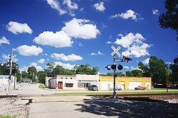
Hickory Flat is served by the Benton County School District.
The climate in this area is characterized by hot, humid summers and generally mild to cool winters. According to the Köppen Climate Classification system, Hickory Flat has a humid subtropical climate, abbreviated "Cfa" on climate maps. [10]
Chatom is a town in Washington County, Alabama, United States. It incorporated in 1949. Chatom is the county seat of Washington County, holding the distinction since 1907. The town's population was 1,288 At the 2010 census, up from 1,193 in 2000.
Howard is a city in and the county seat of Elk County, Kansas, United States. As of the 2020 census, the population of the city was 570.
Centralia is a city in Nemaha County, Kansas, United States. As of the 2020 census, the population of the city was 485.
Cheney is a city in Sedgwick County, Kansas, United States. As of the 2020 census, the population of the city was 2,181.
Carrollton is a town in and the second county seat of Carroll County, Mississippi, United States, which is within the Mississippi Delta. The population was 190 at the 2010 census, down from 408 in 2000. Centrally located in the county, the town is part of the Greenwood, Mississippi micropolitan area. The first county seat, Vaiden, was founded in the eastern part of the county during its early settlement.
The city of Canton is the county seat of Madison County, Mississippi, United States, and is situated in the northern part of the metropolitan area surrounding the state capital, Jackson. The population of Canton was 10,948 at the 2020 census, down from 13,189 in 2010.
Hickory is a town in Newton County, Mississippi. The population was 530 at the 2010 census. The town is named after Andrew Jackson, who was nicknamed "Old Hickory."
Algoma is a town in Pontotoc County, Mississippi. The population was 705 at the 2020 census, up from 590 at the 2010 census.
Blue Mountain is a town in Tippah County, Mississippi, United States. The population was 920 at the 2010 census.
Iuka is a city in and the county seat of Tishomingo County, Mississippi, United States. Its population was 3,028 at the 2010 census. Woodall Mountain, the highest point in Mississippi, is located just south of Iuka.
Lewis Run is a borough in McKean County, Pennsylvania, United States. The population was 578 at the 2020 census.
Pukwana is a town in Brule County, South Dakota, United States. The population was 233 at the 2020 census.
Silverton is a city in Briscoe County, Texas, United States. The population was 629 at the 2020 census.
Roby is a city in and the county seat of Fisher County, Texas, United States. The population was 591 at the 2020 census.
Emory is a city in Rains County, Texas, United States. The population was 1,239 at the 2010 census. It is the county seat of Rains County. Previously known as Springville, the city and county are named after Emory Rains, who was a legislator from the area. Rains was the author of the Homestead Law of Texas, which was later used as a model for the protection of homesteads throughout the United States. Special legislation passed to create Rains County called for the citizens to vote on the location of the county seat and for that selected town to be named Emory.
San Saba is a city located in, and the county seat of, San Saba County, Texas, United States. It was settled in 1854 and named for its location on the San Saba River and for Sabbas the Sanctified. Its population was 3,099 at the 2010 census.
Tye is a city in Taylor County, Texas, United States. Its population was 1,176 at the 2020 census. It is part of the Abilene, Texas metropolitan statistical area.
Woodville is a town in and the county seat of Tyler County, Texas, United States. The town is intersected by three U.S. Numbered Highways: U.S. Route 69, U.S. Route 190, and U.S. Route 287. The population was 2,403 at the 2020 census. It is the county seat of Tyler County. The town was named after George Tyler Wood, governor of Texas from 1847 to 1849.
Ackerly is a city in Dawson and Martin Counties in the U.S. state of Texas. As of the 2020 Census, the population was 264. The Martin county portion of Ackerly is part of the Midland-Odessa metropolitan area.
Hamlin is a city in Jones and Fisher Counties in the U.S. state of Texas. The population was 1,831 at the 2020 census. The Jones County portion of Hamlin is part of the Abilene, Texas metropolitan area.