Related Research Articles
Cross-country skiing is a form of skiing where skiers rely on their own locomotion to move across snow-covered terrain, rather than using ski lifts or other forms of assistance. Cross-country skiing is widely practiced as a sport and recreational activity; however, some still use it as a means of transportation. Variants of cross-country skiing are adapted to a range of terrain which spans unimproved, sometimes mountainous terrain to groomed courses that are specifically designed for the sport.

Snowshoes are specialized outdoor gear for walking over snow. Their large footprint spreads the user's weight out and allows them to travel largely on top of rather than through snow. Adjustable bindings attach them to appropriate winter footwear.

Telemark skiing is a skiing technique that combines elements of Alpine and Nordic skiing, using a squatting motion on downhill skis. Telemark skiing is named after the Telemark region of Norway, where the discipline originated. Sondre Norheim is often credited for first demonstrating the turn in ski races, which included cross country, slalom, and jumping, in Norway around 1868. Sondre Norheim also experimented with ski and binding design, introducing side cuts to skis and heel bindings.
Mount Greylock is a 3,489-foot (1,063-meter) mountain located in the northwest corner of Massachusetts and is the highest point in the state. Its summit is in the western part of the town of Adams in Berkshire County. Technically, Mount Greylock is geologically part of the Taconic Mountains, which are not associated with the abutting Berkshire Mountains to the east. The mountain is known for its expansive views encompassing five states and the only taiga-boreal forest in the state. A seasonal automobile road climbs to the summit, topped by a 93-foot-high (28 m) lighthouse-like Massachusetts Veterans War Memorial Tower. A network of hiking trails traverses the mountain, including the Appalachian Trail. Mount Greylock State Reservation was created in 1898 as Massachusetts' first public land for the purpose of forest preservation.

Tuckerman Ravine is a glacial cirque sloping eastward on the southeast face of Mt. Washington, in the White Mountains of New Hampshire. Although it draws hikers throughout the year, and skiers throughout the winter, it is best known for the many "spring skiers" who ascend it on foot and ski down the steep slope from early April into July. In this period, the temperatures are relatively mild but the natural snowpack — which averages up to 55 feet (17 m) in a typical winter — is still adequate to ski most seasons. The record-setting high winds atop Mount Washington scour a massive amount of snow from the surrounding highlands and drop it here or in the adjacent Huntington Ravine.
Cypress Provincial Park is a provincial park on the North Shore of Metro Vancouver Regional District, British Columbia. The park has two sections: a 21 km2 (8.1 sq mi) southern section which is accessible by road, and a 9 km2 (3.5 sq mi) northern section which is only accessible by hiking trails. Most of the park is in West Vancouver.

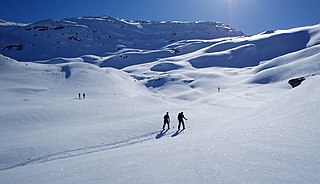
Ski touring is skiing in the backcountry on unmarked or unpatrolled areas. Touring is typically done off-piste and outside of ski resorts, and may extend over a period of more than one day. It is similar to backcountry skiing but excludes the use of a ski lift or transport.

Backcountry skiing (US), also called off-piste (Europe), alpine touring, or out-of-area, is skiing in the backcountry on unmarked or unpatrolled areas either inside or outside a ski resort's boundaries. This contrasts with alpine skiing, which is typically done on groomed trails benefiting from a ski patrol. Unlike ski touring, backcountry skiing can include the use of ski lifts including snowcats and helicopters. Recent improvements in equipment have increased the popularity of the sport.

Cypress Mountain is a ski area in West Vancouver, British Columbia, Canada, located in the southern section of Cypress Provincial Park, operated under a BC Parks Park Use Permit.

Alpental, named after the German word for alpine valley, is both a valley in eastern King County, Washington, United States and a ski area in the valley. The valley is about 50 miles (80 km) east of Seattle, Washington and is north of Snoqualmie Pass, in the Washington Cascades. It is a popular outdoor recreation destination in both the summer and winter. The ski area is one of four areas which make up The Summit at Snoqualmie.

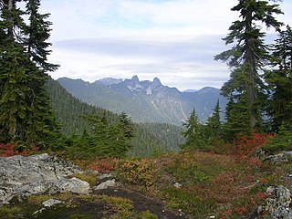
The North Shore Mountains are a mountain range overlooking Vancouver in British Columbia, Canada. Their southernmost peaks are visible from most areas in Vancouver and form a distinctive backdrop for the city.

Banff Sunshine Village is a ski resort in western Canada, located on the Continental Divide of the Canadian Rockies within Banff National Park in Alberta and Mt Assiniboine Provincial Park in British Columbia. It is one of three major ski resorts located in the Banff National Park. Because of its location straddling the Continental Divide, Sunshine receives more snow than the neighbouring ski resorts. The Sunshine base area is located 15 km (9 mi) southwest of the town of Banff. By car, it is about a ninety-minute drive from the city of Calgary; the Sunshine exit on the Trans Canada Highway is 8 km (5 mi) west of the town of Banff.

Mount Greylock State Reservation is public recreation and nature preservation area on and around Mount Greylock, the highest point in the U.S. state of Massachusetts. The park covers some 12,000 acres (4,900 ha) in the towns of Lanesborough, North Adams, Adams, Cheshire, Williamstown and New Ashford, Massachusetts. It was created in 1898 as Massachusetts' first public land for the purpose of forest preservation.

Mount Pinos is a mountain located in the Los Padres National Forest on the boundary between Ventura and Kern counties in California. The summit, at 8,847 feet (2,697 m), is the highest point in Ventura County. The mountain is the highest point of the Transverse Ranges west of Tejon Pass, as well as the southernmost point of the Salinian Block.

June Mountain ski area is a winter resort in the Eastern Sierra Nevada Mountains, located near June Lake, southeast of Yosemite National Park.
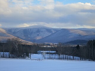
Hogback Mountain is a mountain in southern Vermont, United States, in the town of Marlboro, Vermont, just north of Vermont Route 9. Its main peak is 2,409 feet (734 m) high. The area is well known for expansive views from Route 9.

The California Alpine Club (CAC) is an all-volunteer, outdoors-oriented social group centered in the San Francisco Bay and Sacramento areas that organizes hiking, skiing, member dinners, and wilderness trips. Club members also manage the California Alpine Club Foundation, which gives grants to California-based wilderness preservation, conservation, outdoor recreation, and education projects.

Mount Fitch is the third-highest peak in the Commonwealth of Massachusetts at 3,110 feet (950 m). It is located on the ridge between Mount Greylock at 3,491 feet to its south and Mount Williams at 2,956 feet to its north. The peak sits in the northwest corner of the Town of Adams in Berkshire County. The forested summit is approximately 123 yards (112 m) due west of a local high-point on the Appalachian Trail. Mount Fitch does not meet the Appalachian Mountain Club's prominence criterion of 200 vertical feet of separation from adjacent peaks as outlined in New England's Four-thousand footers list. Currently there is no side-spur trail or signage directing a hiker to the summit of Mt. Fitch from the Appalachian Trail; however, there is a wooden placard at the summit itself. The top is infrequently visited by hikers due to its anonymity, the bushwhack necessary to reach the top and the viewless summit.

Mount Seymour Provincial Park is a park in Vancouver, British Columbia's North Shore Mountains. With an area of 35 square kilometres, it is located approximately 15 kilometres north of Downtown Vancouver. The park, named after Frederick Seymour, was established in 1936. Mount Seymour Provincial Park provides visitors with a variety of recreational activities and animals with natural habitat.
This glossary of skiing and snowboarding terms is a list of definitions of terms and jargon used in skiing, snowboarding, and related winter sports.
References
- ↑ Bellico, Matthew (Feb 22, 2009). "Trail for the Hardy". Boston Globe.
- 1 2 Walsh, Mike (Jan 1, 2019). "Ski it if You Dare". Vermont Country.
- 1 2 3 Vinton, Nathaniel (Nov 5, 2014). "Ghosts of the Thunderbolt". SKI magazine.
- 1 2 Bradley, Matthew Timothy (Feb 17, 2013). "Snowshoeing the Thunderbolt Ski Run". Snowshoe Magazine.
- 1 2 Levulis, Jim (Feb 28, 2014). "Thunderbolt Ski Race Celebrates History Of Mountain's Trailblazers". WAMC (Northeast Public Radio).
- ↑ Sanders, Charles J. (2005). The Boys of Winter: Life and Death in the U.S. Ski Troops During the Second World War. University Press of Colorado. pp. 1–19. ISBN 978-0-87081-823-3.
- ↑ "This Saturday Ski Through History on the Thunderbolt Trail". Valley Advocate. March 4, 2013.
- ↑ "Snowshoeing the Thunderbolt Ski Run". Snowshoe Magazine. March 4, 2013.
- ↑ "Purple Mountains Majesty". Youtube.
- ↑ Davis, Connor W. (Feb 14, 2018). "The Ski Race America Nearly Lost". Ski Racing Magazine.
- 1 2 Given, Karen (Mar 14, 2015). "Skiing The Thunderbolt: A Modern Day Sport Tackles A Historic Trail". WBUR (Boston Local Radio News).
- 1 2 Hutton, Ryan (Dec 16, 2010). "Thunderbolt Ski Runners Gearing up for February Run". Bennington Banner.
- 1 2 3 Stafford, Scott Stafford (Feb 19, 2020). "Thunderbolt Ski Race Returning to Mt Greylock". Berkshire Eagle.
- ↑ Demers, Phil Demers (Mar 2, 2014). "Day of racing, fun in Adams at Thunderbolt Ski Race". Berkshire Eagle.
- ↑ Mingle, Jonathan (Feb 16, 2013). "Skiing Old Trails of the New Deal". The New York Times.
- ↑ Guerino, Jack (Nov 4, 2019). "Thunderbolt Ski Trail Eroding". iBerkshires.
- ↑ "Thunderfest". Berkshire Style.
- ↑ Gentile, Derek (Dec 9, 2012). "Thunderbolt Ski Museum in Adams tells 'significant' local story". Berkshire Eagle.
- ↑ McKeever, Andy (Oct 7, 2012). "Thunderbolt Ski Museum Opens In Adams Visitor's Center". iBerkshires.