
The Spruce Hole Bog, locally known as Spruce Hole, is a complete ecological community occupying a true kettle hole in the town of Durham, New Hampshire. According to the National Register of Natural Landmarks: "It illustrates characteristics of a typical sphagnum-heath bog, localized in a specialized geologic setting." It was designated a National Natural Landmark in 1972. Spruce Hole is located 2 miles (3 km) west of the town center of Durham and is owned by the town, which has conserved 35 acres (14 ha) around it. It is reached by a woods road off Packer's Falls Road, and despite the name, the surrounding forest is mostly white pine, hemlock, and birch.

Orient Beach State Park is a 363-acre (1.47 km2) state park located in Southold, New York. The park is situated at the tip of the North Fork of Long Island.
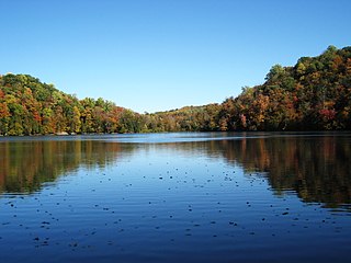
Round Lake National Natural Landmark lies within Green Lakes State Park, which lies a few miles east of the city of Syracuse, New York and adjoining the village of Fayetteville. Round Lake itself and the adjoining 59 acres (24 ha) of old-growth forest were designated a National Natural Landmark in 1973 by the U.S. Department of the Interior. Hubert W. Vogelmann, a professor of botany at the University of Vermont, wrote the evaluation to the National Park Service that concurred with the recommendation of National Natural Landmark status for the region around Round Lake. Vogelmann's evaluation noted the "outstanding virgin mesophytic forest" adjoining Round Lake on its southwestern side; this text became part of the citation when the landmark was created. Vogelmann also noted Round Lake's importance as an extremely rare, "meromictic" lake. It shares this distinction with Green Lake, which lies a few hundred meters to the east.

The National Natural Landmarks (NNL) Program recognizes and encourages the conservation of outstanding examples of the natural history of the United States. It is the only national natural areas program that identifies and recognizes the best examples of biological and geological features in both public and private ownership. The program was established on May 18, 1962, by United States Secretary of the Interior Stewart Udall.
Cook Forest State Park is a 8,500-acre (3,440 ha) Pennsylvania state park in Farmington Township, Clarion County, Barnett Township, Forest County and Barnett Township, Jefferson County, Pennsylvania in the United States. Located just south of the Allegheny National Forest, the park is a heavily wooded area of rolling hills and mountains along the Clarion River in northwestern Pennsylvania. Cook Forest State Park is known for some of America's finest virgin white pine and hemlock timber stands and was once called the "Black Forest" due to the preponderance of evergreen tree coverage.
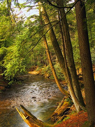
Cathedral State Park is the largest virgin timber tract remaining in West Virginia. The park features trees of up to 90 feet in height and 16 feet in circumference. Located on 132 acres (53 ha) about one mile (1.6 km) east of the town of Aurora and five miles west of Redhouse, Maryland, Cathedral is a mixed forest of predominantly eastern hemlock. Rhine Creek runs through the park.

The Au Sable State Forest is a state forest in the north-central Lower Peninsula of Michigan. It is operated by the Michigan Department of Natural Resources.
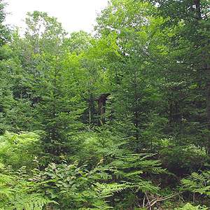
Keeley Creek Natural Area is a Research Natural Area and a National Natural Landmark that is protected by the United States Department of Agriculture, specifically through the branch of the Forest Service. It is located in Stony River Township, in Lake County, Minnesota, and is part of the Superior National Forest.
Lac la Croix Research Natural Area is a natural area that is protected by the United States Department of Agriculture, specifically through the branch of the Forest Service. It was established in 1942 and consists of 973 acres (3.94 km2) of land. It is located in St. Louis County, Minnesota and is part of the Superior National Forest.

Caledon State Park is a 2,579-acre (10.44 km2) state park located in King George, Virginia. As of 2010, the yearly visitation was 49,328. The property was initially owned by the Alexander brothers, founders of the city of Alexandria, and was established in 1659 as Caledon Plantation. Ownership passed, in 1974, to the Commonwealth of Virginia.

Dendron Swamp Natural Area Preserve is a 636-acre (257 ha) Natural Area Preserve in Sussex County, Virginia, USA. Located along the Blackwater River, the preserve supports a bald cypress and tupelo swamp. Canopy trees over 98 feet (30 m) tall line the river for two miles (3.2 km) and the swamp shows only occasional signs of logging. Some of the larger cypresses are believed to be over 600 years old. Within the preserve is a nesting site for the great blue heron.

Flambeau River State Forest is a 90,147 acre (364 km²) unit of the Wisconsin state park system. The North and South Forks of the Flambeau River join within the park, providing over 75 miles (121 km) of mostly undeveloped river. The forest is composed of northern hardwoods. In 1973, Flambeau River Hemlock-Hardwood Forest was designated as a National Natural Landmark by the National Park Service.

The Mianus River Gorge is a 935-acre (3.78 km2) nature preserve in Bedford, New York jointly owned by The Nature Conservancy and Mianus River Gorge, Inc.. The first 60 acres (0.24 km2) were purchased by the Preserve, with help from the Conservancy, their first land preservation deal. It has grown over the years and is still managed by Mianus River Gorge, Inc. In March 1964, it was designated a National Natural Landmark for its old growth climax hemlock forest and the gorge of the Mianus River.
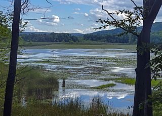
Thompson Pond in Pine Plains, New York is a 75-acre (30 ha) 15,000-year-old glacial kettle pond at the foot of 1,403-foot (428 m) Stissing Mountain. It is the source of Wappinger Creek, a tributary of the Hudson River that drains much of Dutchess County.

Acushnet Cedar Swamp is a 1,100-acre (450 ha) swamp located in Bristol County, Massachusetts. It is managed by the Massachusetts Department of Environmental Protection. In 1972, Acushnet Cedar Swamp was designated as a National Natural Landmark by the National Park Service. The New Bedford Regional Airport borders the swamp to the south.
Rich Hole Wilderness is a designated wilderness area in the James River Ranger District of the George Washington and Jefferson National Forests of Virginia in the United States. The wilderness area was established in 1988 and comprises 6,450 acres (26.1 km2). It is administered by the US Forest Service.
Bose Lake Hemlock Hardwoods is a mature northern hardwood-hemlock stand located within Chequamegon-Nicolet National Forest in Oneida County, Wisconsin. It was designated a National Natural Landmark in 1980. Additionally, it is located within the Franklin and Butternut Lakes Wisconsin State Natural Area.

Gifford Woods State Park is a state park located at the base of Pico Peak in Killington, Vermont. The wooded park provides camping, picnic, and fishing facilities, and has hiking trails, including a portion of the Appalachian Trail. It preserves an area of old-growth forest that has been designated a National Natural Landmark, and is accessible via an interpretive trail. The park was established in 1931. Part of it is listed on the National Register of Historic Places, for facilities developed by the Civilian Conservation Corps in the 1930s.
