Blackinton Historic District

Last updated

Blackinton Historic District
Blackinton Company, North Adams MA.jpg
Blackinton Mill (2010)
USA Massachusetts location map.svg
Red pog.svg
Usa edcp location map.svg
Red pog.svg
LocationRoughly Massachusetts Ave. between Ashton and Doanes Aves. and Church Hill and Boston & Maine RR, North Adams, Massachusetts
Coordinates 42°42′13″N73°9′50″W / 42.70361°N 73.16389°W / 42.70361; -73.16389
Area240 acres (97 ha)
Architectvarious
Architectural styleMid-19th Century Revival, Late Victorian
MPS North Adams MRA
NRHP reference No. 85003384 [1]
Added to NRHPOctober 25, 1985

The Blackinton Historic District is a historic district in the western part of North Adams, Massachusetts, roughly along Massachusetts Avenue between Ashton and Doanes Avenues and Church Hill and the Boston & Maine Railroad. The district, which encompasses North Adams' best preserved mill village, [2] was added to the National Register of Historic Places in 1985.

Contents

History

Lithograph of Blackinton from 1889 by L.R. Burleigh with list of landmarks Blackinton, Mass. (2673694603).jpg
Lithograph of Blackinton from 1889 by L.R. Burleigh with list of landmarks

The neighborhood where the historic district is located is around the mills of the Blackinton Company, founded on the north bank of the Hoosic River in 1821 by Sanford Blackinton, Rufus Wells and J.L White. [3] It was one of the three mill villages, with Greylock and Braytonville, that contributed to the westward expansion of North Adams. It would become one of the largest manufacturers of woolen goods in Western Massachusetts, buoyed especially by large orders from the Union Army during the American Civil War. [2] By the early 1900s the neighborhood was a self-contained community, with its own school, jail, stores, post office, library and fire department, and the people there considered themselves be residents of "Blackinton", not North Adams. The community which historically had been disputed between North Adams and Williamstown had a station on the Boston & Maine, as well as bus service to North Adams. The mill closed in 1950. [4]

Description

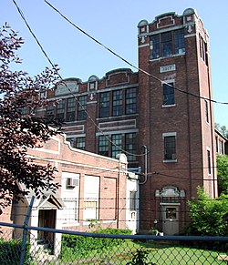
The historic district is basically linear in character, extending along Massachusetts Avenue west of downtown North Adams and north of the Hoosic River. It extends along the north side between Church Hill Road and Wood Street, and on the south side east from Ashton Avenue, to about midway between Wood and Church Hill. The district includes the surviving brick mill buildings between Massachusetts Avenue and the river, the 1839 Blackinton Company Store, two churches, and the c. 1850 Greek Revival residence of Sanford Blackinton. There are also fine examples of later Victorian architecture, including a Queen Anne/Stick style home built by John P. Blackinton in 1880 across the street from the mill complex. [2]

See also

Related Research Articles

<span class="mw-page-title-main">Biddeford, Maine</span> City in Maine, United States

Biddeford is a city in York County, Maine, United States. It is the principal commercial center of York County. Its population was 22,552 at the 2020 census. The twin cities of Saco and Biddeford include the resort communities of Biddeford Pool and Fortunes Rocks. The town is the site of the University of New England and the annual La Kermesse Franco-Americaine Festival. First visited by Europeans in 1616, it is the site of one of the earliest European settlements in the United States. It is home to Saint Joseph's Church, the tallest building in Maine.

<span class="mw-page-title-main">Cheshire, Massachusetts</span> Town in Massachusetts, United States

Cheshire is a town in Berkshire County, Massachusetts, United States. It is part of the Pittsfield, Massachusetts Metropolitan Statistical Area. The population was 3,258 at the 2020 census.

<span class="mw-page-title-main">North Adams, Massachusetts</span> City in Massachusetts, United States

North Adams is a city in Berkshire County, Massachusetts, United States. It is part of the Pittsfield, Massachusetts Metropolitan Statistical Area. Its population was 12,961 as of the 2020 census. Best known as the home of the largest contemporary art museum in the United States, the Massachusetts Museum of Contemporary Art, North Adams has in recent years become a center for tourism, culture and recreation.

<span class="mw-page-title-main">Back Bay, Boston</span> Neighborhood of Boston, Massachusetts, and US historic place

Back Bay is an officially recognized neighborhood of Boston, Massachusetts, built on reclaimed land in the Charles River basin. Construction began in 1859, as the demand for luxury housing exceeded the availability in the city at the time, and the area was fully built by around 1900. It is most famous for its rows of Victorian brownstone homes—considered one of the best preserved examples of 19th-century urban design in the United States—as well as numerous architecturally significant individual buildings, and cultural institutions such as the Boston Public Library, and Boston Architectural College. Initially conceived as a residential-only area, commercial buildings were permitted from around 1890, and Back Bay now features many office buildings, including the John Hancock Tower, Boston's tallest skyscraper. It is also considered a fashionable shopping destination and home to several major hotels.

<span class="mw-page-title-main">Dorchester, Boston</span> Neighborhood of Boston in Suffolk, Massachusetts, United States

Dorchester is a Boston neighborhood comprising more than 6 square miles (16 km2) in the City of Boston, Massachusetts, United States. Originally, Dorchester was a separate town, founded by Puritans who emigrated in 1630 from Dorchester, Dorset, England, to the Massachusetts Bay Colony. This dissolved municipality, Boston's largest neighborhood by far, is often divided by city planners in order to create two planning areas roughly equivalent in size and population to other Boston neighborhoods.

<span class="mw-page-title-main">Central Square, Cambridge</span> United States historic place

Central Square is an area in Cambridge, Massachusetts centered on the junction of Massachusetts Avenue, Prospect Street and Western Avenue. Lafayette Square, formed by the junction of Massachusetts Avenue, Columbia Street, Sidney Street and Main Street, is also considered a part of the Central Square area. Harvard Square is to the northwest along Massachusetts Avenue, Inman Square is to the north along Prospect Street and Kendall Square is to the east along Main Street. The section of Central Square along Massachusetts Avenue between Clinton Street and Main Street is designated the Central Square Historic District, and was added to the National Register of Historic Places in 1990.

<span class="mw-page-title-main">Mattapan</span> Neighborhood of Boston in Suffolk, Massachusetts, United States

Mattapan is a neighborhood in Boston, Massachusetts. Historically and for legal processes a section of Dorchester, Mattapan became a part of Boston when Dorchester was annexed in 1870. Mattapan is the original Native American name for the Dorchester area, possibly meaning "a place to sit." At the 2010 census, it had a population of 36,480, with the majority of its population immigrants.

<span class="mw-page-title-main">Newton Upper Falls</span> United States historic place

Newton Upper Falls is one of the thirteen villages within the city of Newton in Middlesex County, Massachusetts, United States.

<span class="mw-page-title-main">Mission Hill, Boston</span> United States historic place

Mission Hill is a 34 square mile, primarily residential neighborhood of Boston, bordered by Roxbury, Jamaica Plain and Fenway-Kenmore and the town of Brookline. It is home to several hospitals and universities, including Brigham and Women's Hospital and New England Baptist Hospital. Mission Hill is known for its brick row houses and triple decker homes of the late 19th century. The population was estimated at 15,883 in 2011.

<span class="mw-page-title-main">Maple Street Cemetery</span> Historic cemetery in Massachusetts, United States

Maple Street Cemetery is a historic cemetery on Maple Street in Adams, Massachusetts. Established about 1760, it is the town's oldest cemetery, serving as a burying ground for its early Quaker settlers, as well as for some of its prominent 19th-century citizens. It was listed on the National Register of Historic Places in 2004.

<span class="mw-page-title-main">Freeman's Grove Historic District</span> Historic district in Massachusetts, United States

The Freeman's Grove Historic District is a residential historic district in North Adams, Massachusetts. It encompasses a neighborhood north of the city center that is a well-preserved instance of a working class area developed during its industrial heyday in the late 19th century. It includes the Chase Hill Estate as well as all the houses on Chase Avenue, Bracewell Street, Hall Street and several smaller streets adjacent to those. It is roughly bounded by Liberty Street, Eagle Street, Bracewell Avenues and Houghton Street. The district was listed on the National Register of Historic Places in 1985.

<span class="mw-page-title-main">Monument Square–Eagle Street Historic District</span> Historic district in Massachusetts, United States

The Monument Square–Eagle Street Historic District is a historic district encompassing the civic heart of North Adams, Massachusetts. When it was originally designated in 1972, the district encompassed Monument Square – west of the intersection of Main Street and Church Street, and the location of a Civil War memorial – and the area around it. This designation included the North Adams Public Library, the First Baptist Church and First Congregational Church, and a block of shops Eagle Street. In 1988, the district's boundaries were increased to be roughly bounded by Holden, Center and Union Streets, the East Middle School, Summer Street, and Main Street. This expansion extended the district westward along Summer Street to include the US Post Office building and St. John's Church, and eastward to include Colgrove Park, the middle school, and St. Francis Catholic Church. An additional block of commercial buildings was also added on the north side of West Main Street, extending just west of Holden Street.

<span class="mw-page-title-main">Norad Mill</span> United States historic place

The Norad Mill is a historic mill located in Braytonville, North Adams, Massachusetts. It is the oldest mill complex in North Adams that has not had its exterior significantly altered, making visible much of its Italianate styling.

<span class="mw-page-title-main">Williamstown Rail Yard and Station Historic District</span> Historic district in Massachusetts, United States

Williamstown Rail Yard and Station Historic District is a historic district at the junction of Cole Avenue and N. Hoosac Road in Williamstown, Massachusetts.The rail yard was an important junction point for the railroads of the area in the late 19th century, serving as the western terminus for trains passing through the Hoosac Tunnel to points east. The yard's facilities included a locomotive repair shop and a railroad roundhouse, although the latter has not survived. The district was listed the National Register of Historic Places in 1994.

<span class="mw-page-title-main">Summer Street Historic District (Adams, Massachusetts)</span> Historic district in Massachusetts, United States

The Summer Street Historic District encompasses a fashionable 19th-century residential area of Adams, Massachusetts. Centered on the junction of Summer Street with Center and Orchard Streets, it extends mainly north along Summer Street, and includes fine examples of Greek Revival, Late Victorian, and Federal style architecture. It was listed on the National Register of Historic Places in 1985.

The city of New Haven, Connecticut has many distinct neighborhoods. In addition to Downtown, centered on the central business district and the Green, are the following neighborhoods: the west central neighborhoods of Dixwell and Dwight; the southern neighborhoods of The Hill, historic water-front City Point, and the harborside district of Long Wharf; the western neighborhoods of Edgewood, West River, Westville, Amity, and West Rock; East Rock, Cedar Hill, Prospect Hill, and Newhallville in the northern side of town; the east central neighborhoods of Mill River and Wooster Square, an Italian-American neighborhood; Fair Haven, an immigrant community located between the Mill and Quinnipiac rivers; Quinnipiac Meadows and Fair Haven Heights across the Quinnipiac River; and facing the eastern side of the harbor, The Annex and East Shore.

<span class="mw-page-title-main">Fort Hill, Boston</span> United States historic place

Fort Hill is a 0.4 square mile neighborhood and historic district of Roxbury, in Boston, Massachusetts. The approximate boundaries of Fort Hill are Malcolm X Boulevard on the north, Washington Street on the southeast, and Columbus Avenue on the southwest.

<span class="mw-page-title-main">Sanford Mills Historic District</span> Historic district in Maine, United States

The Sanford Mills Historic District encompasses a large industrial complex in the center of Sanford, Maine, United States. From 1867 to 1955, the property was the site of a major textile manufacturing operation that was a major local employer. The site, flanking the Mousam River just north of Sanford's central business district, was listed on the National Register of Historic Places in 2009.

<span class="mw-page-title-main">South Berwick Village Historic District</span> Historic district in Maine, United States

The South Berwick Village Historic District encompasses the historic village center of South Berwick, Maine. First settled in the 1640s, the village developed along a major route between Boston, Massachusetts and Portland, Maine in the early 19th century. The village has about 150 years of architecture reflective of this history, and was listed on the National Register of Historic Places in 2010.

References

Notes

  1. "National Register Information System". National Register of Historic Places . National Park Service. April 15, 2008.
  2. 1 2 3 "NRHP nomination for Blackinton Historic District". Commonwealth of Massachusetts. Retrieved December 5, 2013.
  3. "Sanford Blackinton"
  4. Oehler, Kay; Sheppard, Stephen C.; Benjamin, Blair and Li, Lily. "Shifting Sands in Changing Communities: The Neighborhoods, Social Services, and Cultural Organizations of North Adams, Massachusetts" North Adams: Center for Creative Community Development, 2006. p.5