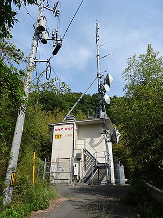
Height above average terrain (HAAT), or (less popularly) effective height above average terrain (EHAAT), is the vertical position of an antenna site above the surrounding landscape. HAAT is used extensively in FM radio and television, as it is more important than effective radiated power (ERP) in determining the range of broadcasts (VHF and UHF in particular, as they are line of sight transmissions). For international coordination, it is officially measured in meters, even by the Federal Communications Commission in the United States, as Canada and Mexico have extensive border zones where stations can be received on either side of the international boundaries. Stations that want to increase above a certain HAAT must reduce their power accordingly, based on the maximum distance their station class is allowed to cover (see List of North American broadcast station classes for more information on this).
The FCC procedure to calculate HAAT is: from the proposed or actual antenna site, either 12 or 16 radials were drawn, and points at 2, 4, 6, 8, and 10 miles (16km) radius along each radial were used. The entire radial graph could be rotated to achieve the best effect for the station. The altitude of the antenna site, minus the average altitude of all the specified points, is the HAAT. This can create some unusual cases, particularly in mountainous regions—it is possible to have a negative number for HAAT (the transmitter would not be located underground, but rather in a valley, with hills on both sides taller than the transmitter itself, for example).
The FCC has divided the Contiguous United States into three zones for the determination of spacing between FM and TV stations using the same frequencies. FM and TV stations are assigned maximum ERP and HAAT values, depending on their assigned zones, to prevent co-channel interference.
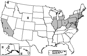
FM broadcast zones in the U.S.
The FCC regulations for ERP and HAAT are listed under Title 47, Part 73 of the Code of Federal Regulations (CFR).
Zone I (the most densely populated zone) consists of the entire land masses of the following states: Connecticut, Delaware, Illinois, Indiana, Maryland, Massachusetts, New Jersey, Ohio, Pennsylvania, Rhode Island, and West Virginia; in addition to the northern and eastern portions of Virginia; the areas of Michigan and southeastern Wisconsin south of 43° 30' north latitude; the coastal strip of Maine; the areas of New Hampshire and Vermont south of 45° north latitude; and the areas of western New York south of 43° 30' north latitude and eastern New York south of 45° north latitude. In addition, Zone I-A (FM only) consists of all of California south of 40° north latitude, Puerto Rico and the U.S. Virgin Islands (If the dividing line between Zones I and II runs through a city, that city is considered to be in Zone I.).
Zones I and I-A have the most "grandfathered" overpowered stations, which are allowed the same extended coverage areas that they had before the zones were established. One of the most powerful of these stations is WBCT in Grand Rapids, Michigan, which operates at 320,000 watts and 238 meters (781ft) HAAT.
Very high frequency (VHF) is the ITU designation for the range of radio frequency electromagnetic waves from 30 to 300 megahertz (MHz), with corresponding wavelengths of ten meters to one meter. Frequencies immediately below VHF are denoted high frequency (HF), and the next higher frequencies are known as ultra high frequency (UHF).
Effective radiated power (ERP), synonymous with equivalent radiated power, is an IEEE standardized definition of directional radio frequency (RF) power, such as that emitted by a radio transmitter. It is the total power in watts that would have to be radiated by a half-wave dipole antenna to give the same radiation intensity as the actual source antenna at a distant receiver located in the direction of the antenna's strongest beam. ERP measures the combination of the power emitted by the transmitter and the ability of the antenna to direct that power in a given direction. It is equal to the input power to the antenna multiplied by the gain of the antenna. It is used in electronics and telecommunications, particularly in broadcasting to quantify the apparent power of a broadcasting station experienced by listeners in its reception area.
The FM broadcast band is a range of radio frequencies used for FM broadcasting by radio stations. The range of frequencies used differs between different parts of the world. In Europe and Africa and in Australia and New Zealand, it spans from 87.5 to 108 megahertz (MHz) - also known as VHF Band II - while in the Americas it ranges from 88 to 108 MHz. The FM broadcast band in Japan uses 76 to 95 MHz, and in Brazil, 76 to 108 MHz. The International Radio and Television Organisation (OIRT) band in Eastern Europe is from 65.9 to 74.0 MHz, although these countries now primarily use the 87.5 to 108 MHz band, as in the case of Russia. Some other countries have already discontinued the OIRT band and have changed to the 87.5 to 108 MHz band.
WGTV is a PBS member television station licensed to Athens, Georgia, United States, a legacy of the station's early years as a service of the University of Georgia (UGA). Owned by the Georgia Public Telecommunications Commission, it is the flagship station of the statewide Georgia Public Broadcasting (GPB) television network, serving the Atlanta metropolitan area from a transmitter atop Stone Mountain just east of Atlanta.
The Arfon transmitting station is a facility for FM, DAB digital radio and television transmission near the villages of Nebo and Nasareth in Gwynedd, northwestern Wales. It includes a 308.5 m (1,012 ft) guyed mast with antennas attached at various heights. The mast is surmounted by a television transmitting antenna, which brings the total height of the structure to 317.4 m (1,041 ft), making it the tallest structure in Wales. It is owned and operated by Arqiva.
A broadcast transmitter is an electronic device which radiates radio waves modulated with information content intended to be received by the general public. Examples are a radio broadcasting transmitter which transmits audio (sound) to broadcast radio receivers (radios) owned by the public, or a television transmitter, which transmits moving images (video) to television receivers (televisions). The term often includes the antenna which radiates the radio waves, and the building and facilities associated with the transmitter. A broadcasting station consists of a broadcast transmitter along with the production studio which originates the broadcasts. Broadcast transmitters must be licensed by governments, and are restricted to specific frequencies and power levels. Each transmitter is assigned a unique identifier consisting of a string of letters and numbers called a callsign, which must be used in all broadcasts.
DZEC-TV is a television station in Metro Manila, Philippines, serving as the flagship of Net 25 network. Owned and operated by the Eagle Broadcasting Corporation, the station maintains studios at the EBC Building, #25 Central Ave., New Era, Quezon City, and its hybrid analog and digital transmitter facility is located at Redeemer Street, Milton Hills Subdivision, Brgy. New Era, Quezon City.
A television station is a set of equipment managed by a business, organisation or other entity such as an amateur television (ATV) operator, that transmits video content and audio content via radio waves directly from a transmitter on the earth's surface to any number of tuned receivers simultaneously.
The Wenvoe transmitting station, officially known as Arqiva Wenvoe, is the main facility for broadcasting and telecommunications for South Wales and the West Country. It is situated close to the village of Wenvoe in the Vale of Glamorgan, Wales, in the UK.
CBU is a Canadian non-commercial public radio station, in Vancouver, British Columbia. It carries the programming of the CBC Radio One network. The station broadcasts on 690 AM and on 88.1 FM as CBU-2-FM. CBU's newscasts and local shows are also heard on a chain of CBC stations around the Lower Mainland.
WHCN is a commercial radio station licensed to Hartford, Connecticut. It broadcasts a classic hits radio format for the Hartford, Waterbury and New Haven areas, and is owned by iHeartMedia, Inc. It is branded "The River 105.9", a reference to the Connecticut River. Its studios and offices are located on Columbus Boulevard in Hartford.
A digital channel election was the process by which television stations in the United States chose which physical radio-frequency TV channel they would permanently use after the analog shutdown in 2009. The process was managed and mandated by the Federal Communications Commission for all full-power TV stations. Low-powered television (LPTV) stations are going through a somewhat different process, and are also allowed to flash-cut to digital.
The Oxford transmitting station is a broadcasting and telecommunications facility, situated on land 129.5 metres (425 ft) above Ordnance Datum to the north east of the city of Oxford, in Oxfordshire, England. It has a guyed steel lattice mast which is 154.4 metres (507 ft) in height to the top of the main steel structure. The UHF television antenna, which consist of a vertical array of transmitting panels, is mounted above the steel structure. The total height of the mast to the top of this UHF antenna is 165.7 metres (544 ft). It is owned and operated by Arqiva.
WKSB is a commercial radio station licensed to serve Williamsport, Pennsylvania. The station is owned by iHeartMedia, Inc., through licensee iHM Licenses, LLC, and broadcasts an adult contemporary format, switching to Christmas music for much of November and December. Its broadcast tower is located on Bald Eagle Mountain south of Williamsport at.
A broadcast relay station, also known as a satellite station, relay transmitter, broadcast translator (U.S.), re-broadcaster (Canada), repeater or complementary station (Mexico), is a broadcast transmitter which repeats the signal of a radio or television station to an area not covered by the originating station.
The Blaenplwyf transmitting station is a broadcasting and telecommunications facility located near the village of Blaenplwyf about 10 kilometres (6 mi) to the south west of the town of Aberystwyth, in Ceredigion, Wales. It was originally built by the BBC, entering service in October 1956 acting as a main transmitter for BBC Band II VHF FM radio.
UHF television broadcasting is the use of ultra high frequency (UHF) radio for over-the-air transmission of television signals. UHF frequencies are used for both analog and digital television broadcasts. UHF channels are typically given higher channel numbers, like the US arrangement with VHF channels (initially) 1 to 13, and UHF channels (initially) numbered 14 to 83. Compared with an equivalent VHF television transmitter, to cover the same geographic area with a UHF transmitter requires a higher effective radiated power, implying a more powerful transmitter or a more complex antenna. However, the additional channels allow more broadcasters in a given region without causing objectionable mutual interference.
WKFY – branded as Koffee FM – is a commercial radio station licensed to East Harwich, Massachusetts, serving Cape Cod and Martha's Vineyard. It is owned by Coxswain Communications, headed by Steve Chessare, through licensee Coxswain Media LLC. It airs a soft adult contemporary radio format, featuring a blend of mellow oldies, primarily from the 1960s, 70s and 80s. The studios and offices are on South Street in Hyannis.
In broadcast engineering, the reference distance is the distance which, under normal circumstances and flat terrain, a radio station would travel with a particular level of signal strength. This distance depends on two factors: effective radiated power (ERP) and height above average terrain (HAAT). The actual distance a station's signal travels depends highly on weather: factors like temperature inversions and heavy precipitation have a strong and highly variable influence on radio propagation. However, for purposes of broadcast law such as construction permits and broadcast licenses, fixed calculations called propagation curves are applied to determine the reference distances for all existing and proposed stations. These also take into account beam tilt, carrier frequency, and even the Earth's curvature at longer distances.
This page is based on this Wikipedia article Text is available under the CC BY-SA 4.0 license; additional terms may apply. Images, videos and audio are available under their respective licenses.