The Appalachian Trail, also called the A.T., is a hiking trail in the Eastern United States, extending almost 2,200 miles (3,540 km) between Springer Mountain in Georgia and Mount Katahdin in Maine, and passing through 14 states. The Appalachian Trail Conservancy claims the Appalachian Trail to be the world's longest hiking-only trail. More than three million people hike segments of it each year.

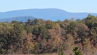
Brasstown Bald is the highest point in the U.S. state of Georgia. It is located in the northeastern part of the state in the Blue Ridge Mountains on the border between Towns and Union counties south of the city of Hiawassee. The mountain is known to the native Cherokee people as Enotah.

The Blue Ridge Parkway is a National Parkway and All-American Road in the United States, noted for its scenic beauty. The parkway, which is the longest linear park in the U.S., runs for 469 miles (755 km) through 29 counties in Virginia and North Carolina, linking Shenandoah National Park to Great Smoky Mountains National Park. It runs mostly along the spine of the Blue Ridge, a major mountain chain that is part of the Appalachian Mountains. Its southern terminus is at U.S. Route 441 (US 441) on the boundary between Great Smoky Mountains National Park and the Qualla Boundary of the Eastern Band of Cherokee Indians in North Carolina, from which it travels north to Shenandoah National Park in Virginia. The roadway continues through Shenandoah as Skyline Drive, a similar scenic road which is managed by a different National Park Service unit. Both Skyline Drive and the Virginia portion of the Blue Ridge Parkway are part of Virginia State Route 48 (SR 48), though this designation is not signed.

Great Smoky Mountains National Park is a national park of the United States in the southeast, with parts in North Carolina and Tennessee. The park straddles the ridgeline of the Great Smoky Mountains, part of the Blue Ridge Mountains, which are a division of the larger Appalachian Mountain chain. The park contains some of the highest mountains in eastern North America, including Kuwohi, Mount Guyot, and Mount Le Conte. The border between the two states runs northeast to southwest through the center of the park. The Appalachian Trail passes through the center of the park on its route from Georgia to Maine. With 13 million visitors in 2023, the Great Smoky Mountains National Park is the most visited national park in the United States.
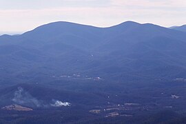
Springer Mountain is a mountain located in the Chattahoochee National Forest on the border of Fannin and Gilmer counties. Located in the Blue Ridge Mountains in northern Georgia, the mountain has an elevation of about 3,770 feet (1,149 m). Springer Mountain serves as the southern terminus for the Appalachian and Benton MacKaye trails.

Cloudland Canyon State Park is a 3,485 acres (14.10 km2) Georgia state park located near Trenton and Cooper Heights on the western edge of Lookout Mountain. One of the largest and most scenic parks in Georgia, it contains rugged geology, and offers visitors a range of vistas across the deep gorge cut through the mountain by Sitton Gulch Creek, where the elevation varies from 800 to over 1,800 feet. Views of the canyon can be seen from the picnic area parking lot, in addition to additional views located along the rim trail. At the bottom of the gorge, two waterfalls cascade across layers of sandstone and shale, ending in small pools below.

Amicalola Falls State Park & Lodge is an 829-acre (3.35 km2) Georgia state park located between Ellijay and Dahlonega in Dawsonville, Georgia. The park's name is derived from a Cherokee language word meaning "tumbling waters". The park is home to Amicalola Falls, a 729-foot (222 m) waterfall that is the highest in Georgia. However, an analysis conducted by the World Waterfall Data base suggests that the main part of the falls is 429 ft (131 m) in height, followed by a prolonged gently sloping run in which the flow drops another 279 ft (85 m). It is considered to be one of the Seven Natural Wonders of Georgia. An 8-mile (13 km) trail that winds past Amicalola Falls and leads to Springer Mountain, famous as the southern terminus of the Appalachian Trail, begins in the park. Amicalola Falls State Park also offers many hiking trails, a guest lodge, restaurant, cabins, a shelter for long-distance Appalachian Trail hikers, a campground, and access to the eco-friendly Len Foote Hike Inn.

The Unicoi Mountains are a mountain range rising along the border between Tennessee and North Carolina in the southeastern United States. They are part of the Blue Ridge Mountain Province of the Southern Appalachian Mountains. The Unicois are located immediately south of the Great Smoky Mountains and immediately west of the Cheoah Mountains. Most of the range is protected as a national forest, namely the Cherokee National Forest on the Tennessee side and the Nantahala National Forest on the North Carolina side— although some parts have been designated as wilderness areas and are thus more strictly regulated.

Vogel State Park is a 233-acre (0.94 km2) or 94 hectares state park located at the base of Blood Mountain in the Chattahoochee National Forest. It became one of the first two parks in Georgia when it founded a state park system in 1931. Much of the park was constructed by the Civilian Conservation Corps during the 1930s.

The Cohutta Wilderness was designated in 1975, expanded in 1986, and currently consists of 36,977 acres (149.64 km2). Approximately 35,268 acres (142.72 km2) are located in Georgia in the Chattahoochee National Forest and approximately 1,709 acres (6.92 km2) are located in Tennessee in the Cherokee National Forest. Combined with the surrounding 96,583-acre Cohutta Wildlife Management Area and the bordering 8,082 acre Big Frog Wilderness, the region spans over 100,000 acres, making it one of the largest contiguous protected areas in the Eastern United States and the largest federally designated wilderness on the East Coast. The Wilderness is managed by the Conasauga Ranger District of the United States Forest Service and is part of the National Wilderness Preservation System.
The Blood Mountain Wilderness was designated in 1991 and currently consists of 7,800 acres (32 km2). The Wilderness is located within the borders of the Chattahoochee National Forest in Lumpkin County and Union County, Georgia. The Wilderness is managed by the United States Forest Service and is part of the National Wilderness Preservation System. In November, 1999, three fires burned through parts of the Blood Mountain Wilderness and the Chattahoochee National Forest. Fire crews came from across the nation to help fight the fires.
The Appalachian National Scenic Trail spans 14 U.S. states over its roughly 2,200 miles (3,500 km): Georgia, North Carolina, Tennessee, Virginia, West Virginia, Maryland, Pennsylvania, New Jersey, New York, Connecticut, Massachusetts, Vermont, New Hampshire, and Maine. The southern end is at Springer Mountain, Georgia, and it follows the ridgeline of the Appalachian Mountains, crossing many of its highest peaks and running almost continuously through wilderness before reaching the northern end at Mount Katahdin, Maine.

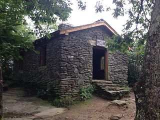
The Walasi-Yi Interpretive Center is a small stone building located along US 19/129 at Neels Gap, Georgia, United States, on the eastern side of Blood Mountain. It is notable as the only place where the 2,175-mile-long Appalachian Trail passes through a man-made structure. It is currently the first mail-drop available to northbound thru-hikers that does not require one to leave the trail.

Black Mountain is located in Georgia USA on the boundary between Dawson and Gilmer counties. The summit is the highest point in Dawson County. It is in the Chattahoochee National Forest and is part of the Blue Ridge Wildlife Management Area.

Mount Oglethorpe is a mountain located in Pickens County, Georgia, United States. The southernmost peak in the Blue Ridge Mountains, the mountain has an elevation of 3,288 feet (1,002 m), making it the highest point in Pickens County.

Roan Mountain is a 6,277 ft (1,913 m) mountain straddling the North Carolina/Tennessee border in the Unaka Range of the Southern Appalachian Mountains in the Southeastern United States. The range's highpoint, Roan is clad in a dense stand of Southern Appalachian spruce–fir forest and includes the world's largest natural rhododendron garden and the longest stretch of grassy bald in the Appalachian range. The Roan Highlands contain the highest quality remaining stretch of Fraser fir forest throughout the tree's entire range. The Cherokee National Forest and Pisgah National Forest converge atop the mountain, with Roan Mountain State Park located near its northern base. The Appalachian Trail traverses most of the Roan's crest. The Roan High Knob Shelter is the highest back-country shelter on the entire 2,174-mile (3,499 km) trail.

Lake Winfield Scott is an 18-acre (7.3 ha) mountain lake located 10 miles (16 km) south of Blairsville, Georgia in Union County. The lake, which is owned and managed by the U.S. Forest Service, is the source of Cooper Creek. It is the centerpiece of the Forest Service's Lake Winfield Scott Recreation Area, a park which features hiking, fishing, boating and other outdoor activities. At 2,854 feet (870 m) elevation it is one of Georgia's highest altitude lakes. The various habitats surrounding the lake support a wide assortment of plants and animals.

The Sugarland Mountain Trail is an American hiking trail, in the Great Smoky Mountains National Park of Sevier County, Tennessee. The trail traverses Sugarland Mountain, a massive ridge running perpendicular to the main crest of the Smokies and effectively dividing the park's north-central section from its northwestern section. Sugarland Mountain is flanked by the deep upper valleys of two of the park's major watersheds— the West Fork of the Little Pigeon River and Little River. The trail passes through several forest types, including deciduous forest at lower elevations, heaths ("hells") along the mountain's backbone formations, and a stand of Southern Appalachian spruce-fir forest in the upper elevations. Occasional breaks in the foliage allow for views of Mount Le Conte and Sevier County to the east and Blanket Mountain and the ridges above Elkmont to the west.
Humpback Rocks is a massive greenstone outcropping near the peak of Humpback Mountain in the Blue Ridge Mountains of Augusta County and Nelson County, Virginia, United States, with a summit elevation of 3,080 feet (940 m). The rock formation is so named for the visual effect of a "hump" it creates on the western face of the mountain.

Pine Log Mountain is located in the U.S. state of Georgia with a summit elevation of 2,338 feet (713 m). The peak and its range is three miles west of the town of Waleska separated only by the gated community of Lake Arrowhead. The summit falls within Cherokee County, although the majority of the mountain range trails into Bartow County including other peaks of Little Pine Log Mountain, Bear Mountain and Hanging Mountain. Pine Log and these other summits within its range are the last mountains over 2,000 feet (600 m) in the Appalachians of north Georgia. The Appalachian range does not rise above 2,000 feet again until many miles further southwest in the Talladega National Forest in Alabama.