Edge Hill is a city in Glascock County, Georgia, United States. The population was 24 at the 2010 census. It is the smallest incorporated city in Georgia by population.
Sugar Hill is a city in northern Gwinnett County in the U.S. state of Georgia and is part of the Atlanta metropolitan area. The population was 18,522 as of the 2010 census, making it the fourth-largest city in Gwinnett County. As of 2015, the estimated population was 21,747.

Dick's Knob or Dicks Knob, with an elevation of 4,620 feet (1,408 m), is the third-highest peak in the State of Georgia if using a 200 ft. prominence rule. It is located in Rabun County, Georgia within the Southern Nantahala Wilderness and is the second-highest mountain in the county.

Tray Mountain, with an elevation of 4,430 ft (1,350 m) is the seventh-highest peak in Georgia. The boundary line between White and Towns counties bisects the mountain, but leaves the summit in Towns County. Habersham County lies on a lower part of the mountain, but not on the summit. Tray Mountain is within the borders of the Chattahoochee National Forest and is part of the Tray Mountain Wilderness. The mountain is referred to by some as the grandstand for viewing the Nantahala Mountains in North Carolina and the rest of the Blue Ridge Mountains in Georgia. The Appalachian Trail crosses the peak.
Rich Mountain, elevation 4,040 feet (1,230 m), is the highest point in the Rich Mountain Wilderness of the Chattahoochee National Forest in Gilmer County, Georgia. It is the second-highest peak in Gilmer County; only Big Bald Mountain is taller, with its summit at 4,081 feet (1,244 m).

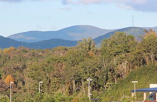
At 4,075 feet (1,242 m), Big Bald Mountain, is the highest peak in Gilmer County, Georgia. It is also located within the boundaries of the Chattahoochee National Forest.

Waterrock Knob is a mountain peak in the U.S. state of North Carolina. It is the highest peak in the Plott Balsams and is the 16th-highest mountain in the Eastern United States.

Old Speck Mountain, also known as Old Speckle Mountain, is a mountain located in Oxford County, Maine, United States. The mountain, the fourth-highest in the state, is the northeasternmost and highest of the Mahoosuc Range, the northeasternmost part of the White Mountains. Old Speck is flanked to the southwest by Mahoosuc Arm, and faces Baldpate Mountain to the northeast across Grafton Notch.

Albert Mountain is a mountain in North Carolina's Nantahala Range of the Appalachian Mountains. The Appalachian Trail goes along its summit, which is around 5,200 feet (1,600 m) high. A fire tower offers views of the Blue Ridge and the Little Tennessee River valley.

Horseleg Mountain is a summit in Floyd County, Georgia, in the United States. With an elevation of 1,322 feet (403 m), Horseleg Mountain is the 735th highest summit in the state of Georgia.

Lumpkin Hill is a summit in Rome, Georgia. With an elevation of 640 feet (200 m), Lumpkin Hill is the 914th highest summit in the state of Georgia. The hill is considered to be one of the Seven Hills of Rome, Georgia.

Old Shorter Hill is a summit in Rome, Georgia. With an elevation of 676 feet (206 m), Old Shorter Hill is the 910th highest summit in the US state of Georgia. It is considered to be one of the Seven Hills of Rome, Georgia.
Snodgrass Hill is a summit in Walker County, Georgia. With an elevation of 896 feet (273 m), Snodgrass Hill is the 886th highest summit in the state of Georgia.

Chinese Peak is a summit in Bannock County, Idaho, in the United States. This peak is the highest point in the portion of the Portneuf Range called the Pocatello Range. With an elevation of 6,791 feet (2,070 m), Chinese Peak is the 1069th highest summit in the state of Idaho. The peak is a fire lookout site and a road/bike trail leads to the top.


