
Austell is a city in Cobb and Douglas counties in the U.S. state of Georgia. It is part of the Atlanta metropolitan area. As of the 2020 census, the city had a population of 7,713.
Druid Hills is a community which includes both a census-designated place (CDP) in unincorporated DeKalb County, Georgia, United States, as well as a neighborhood of the city of Atlanta. The CDP's population was 14,568 at the 2010 census. The CDP formerly contained the main campus of Emory University and the Centers for Disease Control and Prevention (CDC) however they were annexed by Atlanta in 2018. The Atlanta-city section of Druid Hills is one of Atlanta's most affluent neighborhoods with a mean household income in excess of $238,500.

The city of Douglasville is the county seat of and largest city in Douglas County, Georgia, United States. As of the 2020 census, the city had a population of 34,650, up from 30,961 in 2010 and 20,065 in 2000.

Madison is a city in Morgan County, Georgia, United States. It is part of the Atlanta-Athens-Clarke-Sandy Springs Combined Statistical Area. The population was 4,447 at the 2020 census, up from 3,979 in 2010. The city is the county seat of Morgan County and the site of the Morgan County Courthouse.
Lake Claire is a neighborhood on the east side of Atlanta, Georgia, United States, comprising approximately 1,200 homes. It is situated entirely in the DeKalb County side of the city, east of Candler Park, north of Kirkwood, west of Decatur, and south of Druid Hills.
The Battle of Lovejoy's Station was fought on August 20, 1864, near what is now Lovejoy, Georgia, in Clayton County, during the Atlanta Campaign of the American Civil War. The two sides had arrived at something of a stalemate, with the Union army half-encircling Atlanta and the Confederate defenders staying behind their fortifications.

Poncey–Highland is an intown neighborhood on the east side of Atlanta, Georgia, located south of Virginia–Highland. It is so named because it is near the intersection of east/west Ponce de Leon Avenue and north/southwest North Highland Avenue. This Atlanta neighborhood was established between 1905 and 1930, and is bordered by Druid Hills and Candler Park across Moreland Avenue to the east, the Old Fourth Ward across the BeltLine Eastside Trail to the west, Inman Park across the eastern branch of Freedom Parkway to the south, and Virginia Highland to the north across Ponce de Leon Avenue. The Little Five Points area sits on the border of Poncey–Highland, Inman Park, and Candler Park.
International Cotton Exposition (I.C.E.) was a world's fair held in Atlanta, Georgia, from October 4 to December 31 of 1881. The location was along the Western & Atlantic Railroad tracks near the present-day King Plow Arts Center development in the West Midtown area. It planned to show the progress made since the city's destruction during the Battle of Atlanta and new developments in cotton production. It demonstrated the rebirth of Atlanta and the South by announcing an end to the Reconstruction Era and the sectional hostilities that had plagued the nation for several decades.
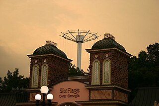
The Great Gasp was a 225-foot-tall (69 m) Intamin Paratower, a "Parachute Drop" ride, that towered over Six Flags Over Georgia for almost 30 years. It became a beacon for the park during this time. The ride was dismantled and removed from the park in 2005.
Loring Heights is a neighborhood of just over 300 homes located in south Buckhead neighborhood of Atlanta, nestled between Peachtree Street, on the east, Northside Drive on the west, and Atlantic Station to the south. Like most of Buckhead, Loring Heights is part of City Council District 8 and is currently represented by Mary Norwood. The neighborhood provides relatively easy access to I-75/85, GA 400, and I-285.

Berkeley Park is a neighborhood located in West Midtown Atlanta, Georgia, United States.
Hunter Hills is a neighborhood located west of downtown Atlanta, Georgia, United States. Its motto, "One Community, One Family", has been its cornerstone since 2001. The neighborhood is encompassed in the 30314 zip code. Hunter Hills shares borders with Mozley Park, Dixie Hills and West Lake neighborhoods. The neighborhood rests just inside Atlanta's perimeter highway I-285, and U.S. Route 78. The schools that serve the neighborhood are Stanton Elementary, Carter G. Woodson Elementary School, Ron Clark Academy, Herndon Elementary and Washington High School, and the Atlanta Job Corps. City of Refuge, a community-based 501(c)(3) non-profit, was established on the 1300 block of Joseph E. Boone Blvd. in 2003 and helps to bring transformation to individuals and families through services including housing, health and wellness, vocational training, and youth development.
Lindridge/Martin Manor is an intown neighborhood of Atlanta, Georgia. It consists mostly of the single-family homes located off Lindbergh Drive in between I-85 and Cheshire Bridge Road. In addition, it includes a small commercial area of three streets west of I-85 bounded by Peachtree Creek, Piedmont Road and the Southern railroad. The neighborhood's boundaries are I-85 on the northwest, Morningside-Lenox Park on the south, and North Druid Hills in unincorporated DeKalb County, Georgia on the east.

Chosewood Park is a neighborhood in southeast Atlanta, Georgia in the United States. It is located south of Peoplestown and Grant Park, west of Boulevard Heights and Benteen Park, northwest of Thomasville Heights and the Atlanta federal penitentiary, and northeast of South Atlanta and Lakewood Heights. It is situated directly on the path of the Atlanta Beltline, which has begun to acquire and develop properties along the rail lines in the Chosewood corridor, including the Boulevard Crossing Park.
Oakland is an officially recognized neighborhood of Atlanta consisting of only four blocks. It is bounded by:
Lenox Park is a neighborhood of homes and office buildings located primarily within the city of Brookhaven, Georgia, just east of the northern border of the city of Atlanta.
Carey Park is a neighborhood on the Upper Westside of Atlanta with a population of 1,739.

Free Nelson Mandela is a sculpture in Atlanta, Georgia, USA, created by David Hammons in 1987. Alternatively referred to as a monument, the piece was originally created as a statement demanding the liberation of the imprisoned South African activist, Nelson Mandela. The official title is Nelson Mandela Must Be Free to Lead His People and South Africa to Peace and Prosperity. However, it is most frequently called just Free Nelson Mandela, because those words are carved in the face of the granite rock that is the bottom portion of the sculpture.

Krog Street Market is a 9-acre (3.6 ha) mixed-use development in Atlanta, located along the BeltLine trail at Edgewood Avenue in Inman Park which opened in Summer 2014. The complex is centered on a 12,000-square-foot (1,100 m2), west coast-style market and restaurants, and also includes up to 300 apartments. The marketplace has been planned to have four or five restaurants and merchants such as florists, cheesemakers, butchers, and bakers under one roof. It is to incorporate two existing parcels on either side of Krog Street: The Stove Works on the west side and the former Tyler Perry Studios at 99 Krog Street, on the east side. The conversion to Krog Street Market is to cost $70 million. The Stove Works is to remain unaltered. Illustrations in the plans show the existing bridge over Krog Street renovated as a pedestrian bridge and incorporated as part of the complex.
Venetian Hills is an official neighborhood in southwest Atlanta, in the U.S. state of Georgia. Its 2010 population was 3,790.