Related Research Articles

Newnan is a city in Metro Atlanta and the county seat of Coweta County, Georgia, about 40 miles (64 km) southwest of Atlanta. Its population was 42,549 at the 2020 census, up from 33,039 in 2010.
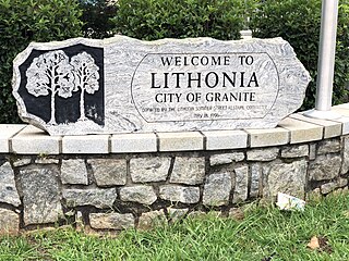
Lithonia is a city in eastern DeKalb County, Georgia, United States. The city's population was 2,662 at the 2020 census. Lithonia is in the Atlanta metropolitan area.

Tyrone is a town in Fayette County, Georgia, United States. The population was 6,879 at the 2010 census, up from 3,916 in 2000. The estimated population in 2018 was 7,388. It is a part of the Atlanta metropolitan area.

Hampton is a city in southwestern Henry County, Georgia, United States. As of the 2010 census, the city had a population of 6,987, up from 3,857 at the 2000 census. By 2018 the estimated population was 7,922. "Hampton" mailing addresses outside the city limits reach into rural parts of eastern Clayton County and northern Spalding County. It is a southeastern suburb in the Atlanta metropolitan area.

Barnesville is a city in Lamar County, Georgia, United States. As of the 2010 census, the city had a population of 6,755, up from 5,972 at the 2000 census. The city is the county seat of Lamar County and is part of the Atlanta metropolitan area.

Greenville is a city and the county seat of Meriwether County, Georgia, United States. The population was 794 at the 2020 census, down from 876 in 2010. The city is located 60 miles (97 km) southwest of Atlanta and is part of the Atlanta metropolitan area.
The Gas South Arena is an indoor arena in Duluth, Georgia. It is located approximately 22 miles (35 km) northeast of Atlanta. The arena is one of the many venues within the "Gas South District", which also includes a convention center with a events hall and a performing arts center.
Georgia's 4th congressional district is a congressional district in the U.S. state of Georgia. The district is currently represented by Democrat Hank Johnson, though the district's boundaries have been redrawn following the 2010 census, which granted an additional congressional seat to Georgia. The first election using the new district boundaries were the 2012 congressional elections.
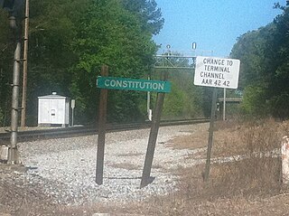
Constitution was a pre-Civil War community south of Atlanta. A prison was located there. Currently, Metro State Prison is located near the old abandoned prison. The city had a circular city limit and half of it was in Fulton County and half of it was in DeKalb County. When Atlanta annexed the Thomasville area in 1952, it took up half of what was left of Constitution, which predated everything around it.

First Church of Christ, Scientist is the main congregation for Atlanta, Georgia’s Christian Science community. Its historic Greek revival church edifice is located on the corner of Fifteenth Street, N.E., and Peachtree Street in the city's Midtown section and is a contributing property in the Ansley Park Historic District.
The Perkerson neighborhood is located in Southwest Atlanta, Georgia in NPU-X. The name change was made by request of residents/members of the Perkerson Civic Association (PCA) in order to keep people from confusing the neighborhood with Perkerson Park which is the large park that serves the area.
Upper Westside is a colloquial area, comprising many historical neighborhoods located in Atlanta, Georgia. The neighborhood is located in the northwestern sector of Atlanta, west of I-75 and inside I-285, to the south of Vinings and to the west of Buckhead. It was developed in the 19th century as an industrial hub.

The Big Bethel AME Church is the oldest African-American congregation in the Sweet Auburn neighborhood of Atlanta, Georgia, and according to AME historical documents, it is the mother church of AME in North Georgia. It is located at 220 Auburn Avenue NE in the Sweet Auburn neighborhood. It is the "first" church on the North Atlanta District, in the Atlanta-North Georgia Annual Conference of the African Methodist Episcopal Church.

Boulevard is a street in and, as a corridor, a subdistrict, of the Old Fourth Ward neighborhood of Atlanta, Georgia. The street runs east of, and parallel to, Atlanta's Downtown Connector. It begins at Ponce de Leon Avenue in the north, passing through the Old Fourth Ward, Cabbagetown, and Grant Park, and forming the border between Chosewood Park on the west and Boulevard Heights and Benteen Park to the east. It ends at McDonough Boulevard in the south, at the Federal Penitentiary.
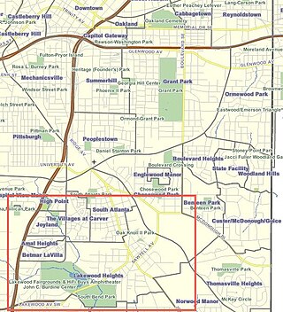
Lakewood Heights is a primarily Black neighborhood in southeast Atlanta. It is bounded by:

The Annunciation Cathedral is a Greek Orthodox Cathedral located in Atlanta, Georgia. It is the seat of the Archbishop of the Metropolis of Atlanta, in the Southeastern United States. The church is known for the rich background and extravagant decoration on both the interior and exterior of the church. The original membership of the parish was 72. The current membership includes over 1200 families.
Macedonia Park, also known as Bagley Park, was a development in what is now the Buckhead Community of Atlanta, Georgia which was located on the present site of Frankie Allen Park in the Garden Hills neighborhood. It was situated in District 17, Land Lot 60. While many African-Americans lived in the area from 1870 to 1920, streets and addresses weren't assigned until the area was developed by John Sheffield Owens, a white developer, in 1921. Despite the area's development, the homes were systemically bought up by Fulton County in the 1940s-50s. The County cited water quality issues and ordered a clean-up of the area, which ultimately led to the razing of the neighborhood.
Greenbriar is a middle-class neighborhood of southwestern Atlanta, Georgia. Greenbriar is a long strip along the east side of the Perimeter (I-285) stretching from Langford Parkway to just south of Stone Road. It is bordered by Atlanta's "Southwest" neighborhood across Langford Parkway to the north, Ben Hill Forest across the Perimeter to the west, and by the city of East Point on the east and south.
Venetian Hills is an official neighborhood in southwest Atlanta, in the U.S. state of Georgia. Its 2010 population was 3,790.
The Roswell Historic District, in Roswell, Georgia in Fulton County, was listed on the National Register of Historic Places in 1974.
References
- ↑ "South Bend Cemetery – Atlanta, Georgia". Wikimapia.org. Retrieved March 26, 2019.
- ↑ Emerson, Bo (August 11, 2012). "Family transforms 1800s cemetery from a jungle into a garden". The Atlanta Journal-Constitution . Cox Enterprises . Retrieved August 20, 2020.