Meriwether, Georgia | |
|---|---|
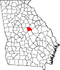
 Meriwether, Georgia Location within the state of Georgia  Meriwether, Georgia Meriwether, Georgia (the United States) | |
| Coordinates: 33°09′18″N83°19′09″W / 33.15500°N 83.31917°W | |
| Country | United States |
| State | Georgia |
| County | Baldwin |
| Elevation | 361 ft (110 m) |
| Time zone | UTC-5 (Eastern (EST)) |
| • Summer (DST) | UTC-4 (EDT) |
| Area code | 478 |
| GNIS ID | 326395 [1] |
Meriwether (also Meriweather,Meriwether Station) is an unincorporated community in Baldwin County, Georgia, United States. [1]
It is the location of Westbrook-Hubert Farm, which is listed on the U.S. National Register of Historic Places.