Manchester, Georgia

Last updated

Manchester, Georgia
Manchester, Georgia.JPG
Manchester in 2012
Meriwether County Georgia Incorporated and Unincorporated areas Manchester Highlighted.svg
Location in Meriwether County and the state of Georgia
Coordinates: 32°51′22″N84°37′3″W / 32.85611°N 84.61750°W / 32.85611; -84.61750
Country United States
State Georgia
Counties Meriwether, Talbot
Area
[1]
  Total8.05 sq mi (20.85 km2)
  Land8.01 sq mi (20.75 km2)
  Water0.04 sq mi (0.09 km2)
Elevation
883 ft (269 m)
Population
 (2020) [2]
  Total3,584
  Density447.27/sq mi (172.69/km2)
Time zone UTC-5 (Eastern (EST))
  Summer (DST) UTC-4 (EDT)
ZIP code
31816
Area code 706
FIPS code 13-49532 [3]
GNIS feature ID0317652 [4]
Website manchester-ga.gov

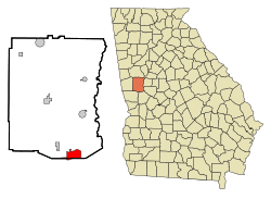
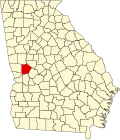
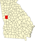
Manchester is a town in Meriwether and Talbot counties in the U.S. state of Georgia, although primarily in Meriwether. The population was 3,584 at the 2020 census, [2] down from 4,230 in 2010. It is the most populous community in Meriwether County. CSX Transportation runs a railroad yard in Manchester.

Contents

History

Manchester was founded in 1907, when the Atlanta, Birmingham and Atlantic Railway was extended northward to that point; it was merged into the Atlantic Coast Line Railroad in 1946. [5] From Manchester the railroad diverged, with one line going to Atlanta and another to Birmingham. The Georgia General Assembly incorporated Manchester as a city in 1909. [6] The city was named after Manchester, in England. [5]

In 2019, CSX Transportation demolished the historic Manchester Yard Office in order to make way for a new, larger, yard facilities building.

Geography

Manchester is in west central Georgia, in southern Meriwether County, with a small portion extending south into Talbot County. The ridge of Pine Mountain runs along the southern edge of the city, rising 300 feet (91 m) above the city to an elevation of 1,180 feet (360 m) above sea level. Georgia State Route 85 is the main highway through the city, leading southwest 39 miles (63 km) to Columbus and north 10 miles (16 km) to Woodbury. Georgia 85 meets Georgia 190 in the southern part of the city, which leads west 16 miles (26 km) along the crest of Pine Mountain to U.S. Route 27 south of the town of Pine Mountain. Georgia 85 meets Georgia 41 in the center of Manchester, which leads southeast 6 miles (10 km) to Woodland and northwest 5 miles (8 km) to Warm Springs.

According to the U.S. Census Bureau, Manchester has a total area of 8.0 square miles (21 km2), of which 0.04 square miles (0.10 km2), or 0.45%, are water. [1] Pigeon Creek runs along the northern border of the city and flows east to the Flint River.

Demographics

Historical population
CensusPop.Note
1910 922
1920 2,776201.1%
1930 3,74534.9%
1940 3,462−7.6%
1950 4,03616.6%
1960 4,1152.0%
1970 4,77916.1%
1980 4,7960.4%
1990 4,104−14.4%
2000 3,988−2.8%
2010 4,2306.1%
2020 3,584−15.3%
U.S. Decennial Census [7]
1850-1870 [8] 1880 [9]
1890-1910 [10] 1920-1930 [11]
1930-1940 [12] 1940-1950 [13]
1960-1980 [14] 1980-2000 [15]
The Manchester Community Building was added to the National Register of Historic Places on January 28, 2002. Manchester Community Building; Manchester, GA (NRHP).JPG
The Manchester Community Building was added to the National Register of Historic Places on January 28, 2002.
Manchester racial composition as of 2020 [16]
RaceNum.Perc.
White (non-Hispanic)1,66646.48%
Black or African American (non-Hispanic)1,71347.8%
Native American 30.08%
Asian 190.53%
Pacific Islander 20.06%
Other/Mixed 1083.01%
Hispanic or Latino 732.04%

As of the 2020 United States census, there were 3,584 people, 1,494 households, and 1,056 families residing in the city.

Notable people

Related Research Articles

<span class="mw-page-title-main">Talbot County, Georgia</span> County in Georgia, United States

Talbot County is a county located in the west central portion of the U.S. state of Georgia. The 2020 census showed a population of 5,733. The county seat and largest city is Talbotton.

<span class="mw-page-title-main">Spalding County, Georgia</span> County in Georgia, United States

Spalding County is a county located in the west central portion of the U.S. state of Georgia. As of the 2020 census, the population was 67,306. The county seat is Griffin. The county was created December 20, 1851 and named for former United States representative and senator Thomas Spalding.

<span class="mw-page-title-main">Pike County, Georgia</span> County in Georgia, United States

Pike County is a county located in the west central portion of the U.S. state of Georgia. As of the 2020 census, the population was 18,889. The county seat is Zebulon.

<span class="mw-page-title-main">Meriwether County, Georgia</span> County in Georgia, United States

Meriwether County is a county located in the west central portion of the U.S. state of Georgia. As of the 2020 census, the population was 20,613. The county seat is Greenville, home of the Meriwether County Courthouse. The county was formed on December 14, 1827, as the 73rd county in Georgia. It was named for David Meriwether, a general in the American Revolutionary War and member of Congress from Georgia.

<span class="mw-page-title-main">Pine Island Center, Florida</span> Census-designated place in Florida, United States

Pine Island Center is an unincorporated community and census-designated place (CDP) located on Pine Island in Lee County, Florida, United States. The population was 1,942 at the 2020 census. It is part of the Cape Coral-Fort Myers, Florida Metropolitan Statistical Area.

<span class="mw-page-title-main">Cypress Gardens, Florida</span> Census-designated place in Florida, United States

Cypress Gardens is a census-designated place (CDP) in Polk County, Florida, United States. The population was 10,169 at the 2020 census. It is part of the Lakeland–Winter Haven Metropolitan Statistical Area.

<span class="mw-page-title-main">Haralson, Georgia</span> Town in Georgia, United States

Haralson is a town in Coweta and Meriwether counties in the U.S. state of Georgia. The population was 172 at the 2020 census. It is noted for being one of the filming locations for both The Walking Dead and Lawless.

<span class="mw-page-title-main">Union City, Georgia</span> City in Georgia, United States

Union City is a city in Fulton County, Georgia, United States. The population was 26,830 at the 2020 census.

<span class="mw-page-title-main">Hampton, Georgia</span> City in Georgia, United States

Hampton is a city in southwestern Henry County, Georgia, United States. The 2020 census was 8368. As of the 2010 census, the city had a population of 6,987, up from 3,857 at the 2000 census. By 2018 the estimated population was 7,922. "Hampton" mailing addresses outside the city limits reach into rural parts of eastern Clayton County and northern Spalding County. It is a southeastern suburb in the Atlanta metropolitan area.

<span class="mw-page-title-main">Gay, Georgia</span> Town in Georgia, United States

Gay is a town in Meriwether County, Georgia, United States. The population was 110 at the 2020 census.

<span class="mw-page-title-main">Greenville, Georgia</span> City in Georgia, United States

Greenville is a city and the county seat of Meriwether County, Georgia, United States. The population was 794 at the 2020 census, down from 876 in 2010. The city is located 60 miles (97 km) southwest of Atlanta and is part of the Atlanta metropolitan area.

<span class="mw-page-title-main">Lone Oak, Georgia</span> Town in Georgia, United States

Lone Oak is a town in Meriwether County, Georgia, United States. The population was 114 at the 2020 census.

<span class="mw-page-title-main">Luthersville, Georgia</span> City in Georgia, United States

Luthersville is a city in Meriwether County, Georgia, United States. The population was 776 at the 2020 census, down from 874 in 2010.

<span class="mw-page-title-main">Warm Springs, Georgia</span> City in the United States

Warm Springs is a city in Meriwether County, Georgia, United States. The population was 465 at the 2020 census.

<span class="mw-page-title-main">Woodbury, Georgia</span> City in Georgia, United States

Woodbury is a city in Meriwether County, Georgia, United States. The population was 908 at the 2020 census.

<span class="mw-page-title-main">Junction City, Georgia</span> Town in Georgia, United States

Junction City is a town in Talbot County, Georgia, United States. The population was 138 at the 2020 census.

<span class="mw-page-title-main">Sylvan Lake, Michigan</span> City in Michigan, United States

Sylvan Lake is a city in Oakland County in the U.S. state of Michigan. A northern suburb of Detroit, Sylvan Lake is located roughly 26 miles (41.8 km) from downtown Detroit, and borders Pontiac to the east. As of the 2010 census, the city had a population of 1,720. With a land area of 0.51 square miles (1.32 km2), Sylvan Lake is the fourth-smallest city by land area in the state after Clarkston, Petersburg, and neighboring Keego Harbor.

<span class="mw-page-title-main">Greene Township, Pike County, Pennsylvania</span> Township in Pennsylvania, United States

Greene Township is a township in Pike County, Pennsylvania, United States. The population was 3,453 at the 2020 census.

<span class="mw-page-title-main">Union Hill-Novelty Hill, Washington</span> Census-designated place in Washington, United States

Union Hill-Novelty Hill is a census-designated place (CDP) in King County, Washington, United States. The area was first recognized by the Census Bureau in the 2000 census. The population was 18,805 at the 2010 census.

<span class="mw-page-title-main">Winnsboro, Texas</span> City in Texas, United States

Winnsboro is a city in Franklin and Wood counties in northeastern Texas, United States, north of Tyler. The population was 3,434 at the 2010 census, down from 3,584 at the 2000 census. Settlement of Winnsboro began in the 1850s with a post office established between 1854 and 1855.

References

  1. 1 2 "2022 U.S. Gazetteer Files: Georgia". United States Census Bureau. Retrieved January 24, 2023.
  2. 1 2 "P1. Race – Manchester city, Georgia: 2020 DEC Redistricting Data (PL 94-171)". U.S. Census Bureau. Retrieved January 24, 2023.
  3. "U.S. Census website". United States Census Bureau . Retrieved December 1, 2008.
  4. "US Board on Geographic Names". United States Geological Survey. October 25, 2007. Retrieved January 1, 2008.
  5. 1 2 Krakow, Kenneth K. (1975). Georgia Place-Names: Their History and Origins (PDF). Macon, GA: Winship Press. p. 143. ISBN   0-915430-00-2.
  6. Acts and Resolutions of the General Assembly of the State of Georgia. State printer. 1909. p. 1071.
  7. "Decennial Census of Population and Housing by Decades". US Census Bureau.
  8. "1870 Census of Population - Georgia" (PDF). US Census Bureau . 1870.
  9. "1880 Census of Population - Georgia" (PDF). US Census Bureau . 1880.
  10. "1910 Census of Population - Georgia" (PDF). US Census Bureau . 1930.
  11. "1930 Census of Population - Georgia" (PDF). US Census Bureau . 1930. p. 253.
  12. "1940 Census of Population - Georgia" (PDF). US Census Bureau . 1940.
  13. "1950 Census of Population - Georgia" (PDF). US Census Bureau . 1980.
  14. "1980 Census of Population - Number of Inhabitants - Georgia" (PDF). US Census Bureau . 1980.
  15. "2000 Census of Population - General Population Characteristics - Georgia" (PDF). US Census Bureau . 2000.
  16. "Explore Census Data". data.census.gov. Retrieved December 14, 2021.
  17. "Stuart Woods Official Website". www.stuartwoods.com. Archived from the original on October 3, 2002. Retrieved May 22, 2022.