Geneva, Georgia

Last updated

Geneva, Georgia
Geneva, Georgia.JPG
Geneva, Georgia (2012)
Talbot County Georgia Incorporated and Unincorporated areas Geneva Highlighted.svg
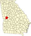
Location in Talbot County and the state of Georgia
Coordinates: 32°34′46″N84°33′2″W / 32.57944°N 84.55056°W / 32.57944; -84.55056
Country United States
State Georgia
County Talbot
Area
[1]
  Total0.79 sq mi (2.04 km2)
  Land0.79 sq mi (2.04 km2)
  Water0.00 sq mi (0.00 km2)
Elevation
584 ft (178 m)
Population
 (2020)
  Total75
  Density95.30/sq mi (36.80/km2)
Time zone UTC-5 (Eastern (EST))
  Summer (DST) UTC-4 (EDT)
ZIP code
31810
Area code 706
FIPS code 13-32412 [2]
GNIS feature ID0355991 [3]

Geneva is a town in Talbot County, Georgia, United States. The population was 75 at the 2020 census.

Contents

History

The Georgia General Assembly incorporated the Town of Geneva in 1870. [4] The community's name is a transfer from Geneva, in Switzerland. [5]

Geography

Geneva is located at 32°34′46″N84°33′2″W / 32.57944°N 84.55056°W / 32.57944; -84.55056 (32.579438, -84.550485). [6]

The town is located in the southern portion of the county along U.S. Route 80, which leads north 8 mi (13 km) to Talbotton, the county seat, and west 33 mi (53 km) to Columbus. The newly constructed Fall Line Freeway also runs through the town as well, leading east 6 mi (10 km) to Junction City, concurrent with Georgia State Route 96, which begins in the town. Georgia State Route 41 also runs through the town, following U.S. Route 80 to Talbotton and leading south 20 mi (32 km) to Buena Vista.

According to the United States Census Bureau, the town has a total area of 0.8 square miles (2.1 km2), all land.

Demographics

Historical population
CensusPop.Note
1880 254
1900 264
1910 210−20.5%
1920 2100.0%
1930 179−14.8%
1940 20313.4%
1950 2093.0%
1960 26225.4%
1970 250−4.6%
1980 232−7.2%
1990 182−21.6%
2000 114−37.4%
2010 105−7.9%
2020 75−28.6%
U.S. Decennial Census [7]
1850-1870 [8] 1870-1880 [9]
1890-1910 [10] 1920-1930 [11]
1940 [12] 1950 [13] 1960 [14]
1970 [15] 1980 [16] 1990 [17]
2000 [18] 2010 [19] 2020 [20]
Geneva town, Georgia – Racial and Ethnic Composition
(NH = Non-Hispanic)
Note: the US Census treats Hispanic/Latino as an ethnic category. This table excludes Latinos from the racial categories and assigns them to a separate category. Hispanics/Latinos may be of any race.
Race / EthnicityPop 2010 [19] Pop 2020 [20] % 2010% 2020
White alone (NH)322830.48%37.33%
Black or African American alone (NH)723968.57%52.00%
Native American or Alaska Native alone (NH)100.85%0.00%
Asian alone (NH)000.00%0.00%
Pacific Islander alone (NH)000.00%0.00%
Some Other Race alone (NH)000.00%0.00%
Mixed Race/Multi-Racial (NH)020.00%2.67%
Hispanic or Latino (any race)060.00%8.00%
Total10575100.00%100.00%

As of the census [2] of 2000, there were 114 people, 52 households, and 34 families residing in the town. In 2020, there were 75 people residing in the town.

Related Research Articles

<span class="mw-page-title-main">Talbot County, Georgia</span> County in Georgia, United States

Talbot County is a county located in the west central portion of the U.S. state of Georgia. The 2020 census showed a population of 5,733. The county seat and largest city is Talbotton.

<span class="mw-page-title-main">Midville, Georgia</span> City in Georgia, United States

Midville is a city in Burke County, Georgia, United States. The population was 269 at the 2010 census, and 385 in 2020. It is part of the Augusta, Georgia metropolitan area.

<span class="mw-page-title-main">Dooling, Georgia</span> Town in Georgia, United States

Dooling is a town in Dooly County, Georgia, United States. The population was 68 at the 2020 census.

<span class="mw-page-title-main">Siloam, Georgia</span> Town in Georgia, United States

Siloam is a town in Greene County, Georgia, United States. The population was 282 at the 2010 census, down from 331 in 2000.

<span class="mw-page-title-main">Union Point, Georgia</span> City in Georgia, United States

Union Point is a city in Greene County, Georgia, United States. As of the 2020 census, the city population was 1,597.

<span class="mw-page-title-main">White Plains, Georgia</span> City in Georgia, United States

White Plains is a city in Greene County, Georgia, United States. The population was 284 at the 2010 census.

<span class="mw-page-title-main">Oglethorpe, Georgia</span> City in Georgia, United States

Oglethorpe is a city in Macon County, Georgia, United States. The population was 995 at the 2020 census, down from 1,328 in 2010. The city is the county seat of Macon County. It was named for Georgia's founder, James Oglethorpe.

<span class="mw-page-title-main">Coleman, Georgia</span> Place in Georgia, United States

Coleman is a former incorporated city in Randolph County, Georgia, United States. It is listed as a census-designated place (CDP). The population was 149 at the 2000 census. The city was abolished by House Bill 1102 effective January 1, 2007, and no longer exists as a municipality.

<span class="mw-page-title-main">Junction City, Georgia</span> Town in Georgia, United States

Junction City is a town in Talbot County, Georgia, United States. The population was 138 at the 2020 census.

<span class="mw-page-title-main">Talbotton, Georgia</span> City in Georgia, United States

Talbotton is a city in Talbot County, Georgia, United States. The population was 970 at the 2010 census. The city is the county seat of Talbot County.

<span class="mw-page-title-main">Woodland, Georgia</span> City in Georgia, United States

Woodland is a city in Talbot County, Georgia, United States. The population was 305 in 2020.

<span class="mw-page-title-main">Danville, Georgia</span> Town in Georgia, United States

Danville is a town in Twiggs and Wilkinson counties in the U.S. state of Georgia. The population was 238 at the 2010 census, down from 373 in 2000.

<span class="mw-page-title-main">Lincoln Park, Georgia</span> Place in Georgia, United States

Lincoln Park is an unincorporated community and census-designated place (CDP) in Upson County, Georgia, United States. The population was 1,122 at the 2000 census.

<span class="mw-page-title-main">Salem, Georgia</span> Place in Georgia, United States

Salem is an unincorporated community and census-designated place (CDP) in Upson County, Georgia, United States. The population was 310 at the 2010 census.

<span class="mw-page-title-main">Norwood, Georgia</span> City in Georgia, United States

Norwood is a city in Warren County, Georgia, United States. The population was 202 in 2020.

<span class="mw-page-title-main">Alamo, Georgia</span> Town in Georgia, United States

Alamo is a town in Wheeler County, Georgia, United States. As of the 2020 census, the town had a population of 771. The town is the county seat of Wheeler County.

Cataula is an unincorporated community and census-designated place (CDP) in Harris County, Georgia, United States.

<span class="mw-page-title-main">Knoxville, Georgia</span> Place in Georgia, United States

Knoxville is an unincorporated community and census-designated place in Crawford County, Georgia, United States. It is the county seat of Crawford County. The community is part of the Macon Metropolitan Statistical Area. As of the 2020 census, Knoxville had a population of 65.

<span class="mw-page-title-main">Boykin, Georgia</span> Place in Georgia, United States

Boykin is an unincorporated community and census-designated place (CDP) in Miller County, Georgia, United States. The 2020 census listed a population of 151.

Empire is an unincorporated community and census-designated place in Dodge and Bleckley counties in the U.S. state of Georgia. As of the 2020 census, the CDP had a population of 319.

References

  1. "2020 U.S. Gazetteer Files". United States Census Bureau. Retrieved December 18, 2021.
  2. 1 2 "U.S. Census website". United States Census Bureau . Retrieved January 31, 2008.
  3. "US Board on Geographic Names". United States Geological Survey. October 25, 2007. Retrieved January 31, 2008.
  4. Acts and Resolutions of the General Assembly of the State of Georgia. Clark & Hines, State Printers. 1870. p. 191.
  5. Krakow, Kenneth K. (1975). Georgia Place-Names: Their History and Origins (PDF). Macon, GA: Winship Press. p. 92. ISBN   0-915430-00-2.
  6. "US Gazetteer files: 2010, 2000, and 1990". United States Census Bureau. February 12, 2011. Retrieved April 23, 2011.
  7. "Decennial Census of Population and Housing by Decade". US Census Bureau.
  8. "1870 Census of Population - Georgia - Population of Civil Divisions less than Counties" (PDF). US Census Bureau . 1870.
  9. "1880 Census of Population - Georgia - Population of Civil Divisions less than Counties" (PDF). US Census Bureau . 1880.
  10. "1910 Census of Population - Georgia" (PDF). US Census Bureau . 1930.
  11. "1930 Census of Population - Georgia" (PDF). US Census Bureau . 1930. p. 251-256.
  12. "1940 Census of Population - Georgia" (PDF). US Census Bureau . 1940.
  13. "1950 Census of Population - Georgia" (PDF). US Census Bureau . 1980.
  14. "1960 Census of Population - Population of County Subdivisions - Georgia" (PDF). US Census Bureau . 1960.
  15. "1970 Census of Population - Population of County Subdivisions - Georgia" (PDF). US Census Bureau . 1970.
  16. "1980 Census of Population - Number of Inhabitants - Georgia" (PDF). US Census Bureau . 1980.
  17. "1990 Census of Population - Summary Social, Economic, and Housing Characteristics - Georgia" (PDF). US Census Bureau . 1990.
  18. "2000 Census of Population - General Population Characteristics - Georgia" (PDF). US Census Bureau . 2000.
  19. 1 2 "P2 Hispanic or Latino, and Not Hispanic or Latino by Race – 2010: DEC Redistricting Data (PL 94-171) – Geneva town, Georgia". United States Census Bureau .
  20. 1 2 "P2 Hispanic or Latino, and Not Hispanic or Latino by Race – 2020: DEC Redistricting Data (PL 94-171) - Geneva town, Georgia". United States Census Bureau .