Junction City, Georgia

Last updated

Junction City, Georgia
Junction City, GA.jpg
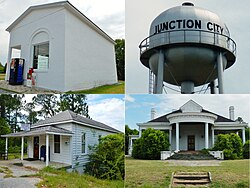
Junction City (in 2012)
Talbot County Georgia Incorporated and Unincorporated areas Junction City Highlighted.svg
Location in Talbot County and the state of Georgia
Coordinates: 32°36′11″N84°27′29″W / 32.60306°N 84.45806°W / 32.60306; -84.45806
Country United States
State Georgia
County Talbot
Area
[1]
  Total2.48 sq mi (6.42 km2)
  Land2.35 sq mi (6.09 km2)
  Water0.13 sq mi (0.33 km2)
Elevation
[2]
689 ft (210 m)
Population
 (2020)
  Total138
  Density58.70/sq mi (22.67/km2)
Time zone UTC-5 (Eastern (EST))
  Summer (DST) UTC-4 (EDT)
ZIP code
31812
Area code 706
FIPS code 13-42800 [3]
GNIS feature ID316309 [2]

Junction City is a town in Talbot County, Georgia, United States. The population was 138 at the 2020 census.

Contents

History

Junction City was platted at the site of a railway junction, hence the name. [4] The Georgia General Assembly incorporated Junction City as a town in 1906. [5]

Geography

Junction City is located at 32°36′11″N84°27′29″W / 32.60306°N 84.45806°W / 32.60306; -84.45806 (32.603083, -84.458190). [6]

The city is located along the Fall Line Freeway (GA state routes 96 and 540), which runs west to east through the town, leading east 15 mi (24 km) to Butler and west 39 mi (63 km) to Columbus. Georgia State Route 90 also runs through the town, leading northwest 8 mi (13 km) to Talbotton, the county seat, and southeast 8 mi (13 km) to Mauk.

According to the United States Census Bureau, the town has a total area of 2.5 square miles (6.5 km2), of which 2.5 square miles (6.5 km2) is land and 0.1 square miles (0.26 km2) (2.35%) is water.

Demographics

Historical population
CensusPop.Note
1910 225
1920 32343.6%
1930 3415.6%
1940 326−4.4%
1950 259−20.6%
1960 226−12.7%
1970 26919.0%
1980 254−5.6%
1990 182−28.3%
2000 179−1.6%
2010 177−1.1%
2020 138−22.0%
U.S. Decennial Census [7]
1850-1870 [8] 1880 [9]
1890-1910 [10] 1920-1930 [11]
1930-1940 [12] 1940-1950 [13]
1960-1980 [14] 1980-2000 [15]
Junction City, Georgia – Racial and Ethnic Composition
(NH = Non-Hispanic)
Note: the US Census treats Hispanic/Latino as an ethnic category. This table excludes Latinos from the racial categories and assigns them to a separate category. Hispanics/Latinos may be of any race.
Race / EthnicityPop 2000 [16] Pop 2010 [17] Pop 2020 [18] % 2000% 2010% 2020
White alone (NH)68353837.99%19.77%27.54%
Black or African American alone (NH)1081359860.34%76.27%71.01%
Native American or Alaska Native alone (NH)2001.12%0.00%0.00%
Asian alone (NH)0000.00%0.00%0.00%
Pacific Islander alone (NH)0000.00%0.00%0.00%
Some Other Race alone (NH)0000.00%0.00%0.00%
Mixed Race/Multi-Racial (NH)0120.00%0.56%1.45%
Hispanic or Latino (any race)1600.56%3.39%0.00%
Total179177138100.00%100.00%100.00%

Junction City first appeared in the 1910 U.S. census, with a population of 225. [10] As of the 2020 census, its population was 138.

Related Research Articles

<span class="mw-page-title-main">Talbot County, Georgia</span> County in Georgia, United States

Talbot County is a county located in the west central portion of the U.S. state of Georgia. The 2020 census showed a population of 5,733. The county seat and largest city is Talbotton.

<span class="mw-page-title-main">Seminole County, Georgia</span> County in Georgia, United States

Seminole County is a county located in the southwestern corner of U.S. state of Georgia. As of the 2020 census, the population was 9,147. The county seat is Donalsonville.

<span class="mw-page-title-main">Macon County, Georgia</span> County in Georgia, United States

Macon County is a county located in the west central portion of the U.S. state of Georgia. As of the 2020 census, the population was 12,082. The county seat is Oglethorpe.

<span class="mw-page-title-main">Dougherty County, Georgia</span> County in Georgia, United States

Dougherty County is located in the southwestern portion of the U.S. state of Georgia. As of the 2020 census, the population was 85,790. The county seat and sole incorporated city is Albany.

<span class="mw-page-title-main">Keysville, Georgia</span> Town in Georgia, United States

Keysville is a town in Burke and Jefferson counties in the U.S. state of Georgia. As of the 2020 census, the city's population was 300.

<span class="mw-page-title-main">Midville, Georgia</span> City in Georgia, United States

Midville is a city in Burke County, Georgia, United States. The population was 269 at the 2010 census, and 385 in 2020. It is part of the Augusta, Georgia metropolitan area.

<span class="mw-page-title-main">Dooling, Georgia</span> Town in Georgia, United States

Dooling is a town in Dooly County, Georgia, United States. The population was 68 at the 2020 census.

<span class="mw-page-title-main">Oglethorpe, Georgia</span> City in Georgia, United States

Oglethorpe is a city in Macon County, Georgia, United States. The population was 995 at the 2020 census, down from 1,328 in 2010. The city is the county seat of Macon County. It was named for Georgia's founder, James Oglethorpe.

<span class="mw-page-title-main">Culloden, Georgia</span> City in Georgia, United States

Culloden is a city in Monroe County, Georgia, United States. The population was 200 in the 2020 census. It is part of the Macon metropolitan statistical area.

<span class="mw-page-title-main">Coleman, Georgia</span> Place in Georgia, United States

Coleman is a former incorporated city in Randolph County, Georgia, United States. It is listed as a census-designated place (CDP). The population was 149 at the 2000 census. The city was abolished by House Bill 1102 effective January 1, 2007, and no longer exists as a municipality.

<span class="mw-page-title-main">Oliver, Georgia</span> City in Georgia, United States

Oliver is a city in Screven County, Georgia, United States. The population was 210 as of 2020.

<span class="mw-page-title-main">Geneva, Georgia</span> Town in Georgia, United States

Geneva is a town in Talbot County, Georgia, United States. The population was 75 at the 2020 census.

<span class="mw-page-title-main">Danville, Georgia</span> Town in Georgia, United States

Danville is a town in Twiggs and Wilkinson counties in the U.S. state of Georgia. The population was 238 at the 2010 census, down from 373 in 2000.

<span class="mw-page-title-main">Hannahs Mill, Georgia</span> Place in Georgia, United States

Hannahs Mill is an unincorporated community and census-designated place (CDP) in Upson County, Georgia, United States. The population was 3,267 at the 2000 census.

<span class="mw-page-title-main">Lincoln Park, Georgia</span> Place in Georgia, United States

Lincoln Park is an unincorporated community and census-designated place (CDP) in Upson County, Georgia, United States. The population was 1,122 at the 2000 census.

<span class="mw-page-title-main">Salem, Georgia</span> Place in Georgia, United States

Salem is an unincorporated community and census-designated place (CDP) in Upson County, Georgia, United States. The population was 310 at the 2010 census.

<span class="mw-page-title-main">Norwood, Georgia</span> City in Georgia, United States

Norwood is a city in Warren County, Georgia, United States. The population was 202 in 2020.

<span class="mw-page-title-main">Harrison, Georgia</span> Town in Georgia, United States

Harrison is a town in Washington County, Georgia, United States. The population was 339 in 2020.

<span class="mw-page-title-main">Alamo, Georgia</span> Town in Georgia, United States

Alamo is a town in Wheeler County, Georgia, United States. As of the 2020 census, the town had a population of 771. The town is the county seat of Wheeler County.

<span class="mw-page-title-main">McIntyre, Georgia</span> Town in Georgia, United States

McIntyre is a town in Wilkinson County, Georgia, United States. The population was 575 in 2020.

References

  1. "2020 U.S. Gazetteer Files". United States Census Bureau. Retrieved December 18, 2021.
  2. 1 2 "Junction City". Geographic Names Information System . United States Geological Survey, United States Department of the Interior.
  3. "U.S. Census website". United States Census Bureau . Retrieved January 31, 2008.
  4. Krakow, Kenneth K. (1975). Georgia Place-Names: Their History and Origins (PDF). Macon, GA: Winship Press. p. 123. ISBN   0-915430-00-2.
  5. Acts and Resolutions of the General Assembly of the State of Georgia. Clark & Hines, State Printers. 1906. p. 826.
  6. "US Gazetteer files: 2010, 2000, and 1990". United States Census Bureau. February 12, 2011. Retrieved April 23, 2011.
  7. "Decennial Census of Population and Housing by Decades". US Census Bureau.
  8. "1870 Census of Population - Georgia" (PDF). US Census Bureau . 1870.
  9. "1880 Census of Population - Georgia" (PDF). US Census Bureau . 1880.
  10. 1 2 "1910 Census of Population - Georgia" (PDF). US Census Bureau . 1930.
  11. "1930 Census of Population - Georgia" (PDF). US Census Bureau . 1930. p. 253.
  12. "1940 Census of Population - Georgia" (PDF). US Census Bureau . 1940.
  13. "1950 Census of Population - Georgia" (PDF). US Census Bureau . 1980.
  14. "1980 Census of Population - Number of Inhabitants - Georgia" (PDF). US Census Bureau . 1980.
  15. "2000 Census of Population - General Population Characteristics - Georgia" (PDF). US Census Bureau . 2000.
  16. "P004 Hispanic or Latino, and Not Hispanic or Latino by Race – 2000: DEC Summary File 1 – Junction City, Georgia". United States Census Bureau .
  17. "P2 Hispanic or Latino, and Not Hispanic or Latino by Race – 2010: DEC Redistricting Data (PL 94-171) - Junction City, Georgia". United States Census Bureau .
  18. "P2 Hispanic or Latino, and Not Hispanic or Latino by Race – 2020: DEC Redistricting Data (PL 94-171) - Junction City, Georgia". United States Census Bureau .