Damascus, Georgia

Last updated

Damascus, Georgia
Damascus City Hall Police Department.jpg
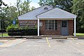
Damascus City Hall and Police Department
Early County Georgia Incorporated and Unincorporated areas Damascus Highlighted.svg
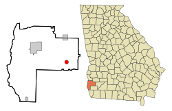
Location in Early County and the state of Georgia
Coordinates: 31°17′55″N84°43′3″W / 31.29861°N 84.71750°W / 31.29861; -84.71750
Country United States
State Georgia
County Early
Area
[1]
  Total1.77 sq mi (4.58 km2)
  Land1.76 sq mi (4.56 km2)
  Water0.01 sq mi (0.02 km2)
Elevation
220 ft (67 m)
Population
 (2020)
  Total212
  Density120.39/sq mi (46.48/km2)
Time zone UTC-5 (Eastern (EST))
  Summer (DST) UTC-4 (EDT)
ZIP codes
31741, 39841
Area code 229
FIPS code 13-21436 [2]
GNIS feature ID0355426 [3]

Damascus is a city in Early County, Georgia, United States. The population was 212 in the 2020 census, down from 254 in the 2010 census. [4]

Contents

History

An early variant name was Kestler. [5] An act of Georgia General Assembly officially changed the name to Damascus in 1914. [6] The present name is a transfer from nearby Old Damascus, which it was named for Damascus, Syria. Old Damascus would be bypassed when a new railroad line was being built through the area. [5]

In 2021, an EF2 tornado struck the area south of town, causing major damage and injuring five people. [7] [8]

On June 14, 2023, a tornado struck the town destroying a home and slightly injuring three people.

Geography

Damascus is located in eastern Early County at 31°17′55″N84°43′3″W / 31.29861°N 84.71750°W / 31.29861; -84.71750 (31.298580, -84.717429). [9] Georgia State Route 45 passes through the community, leading north 10 miles (16 km) to Arlington and south 9 miles (14 km) to Colquitt. Georgia State Route 200 also passes through the center of town, leading east 24 miles (39 km) to Newton and northwest 15 miles (24 km) to Blakely, the Early County seat.

According to the United States Census Bureau, Damascus has a total area of 1.8 square miles (4.6 km2), of which 0.01 square miles (0.02 km2), or 0.48%, is water. [4]

Demographics

Historical population
CensusPop.Note
1910 413
1920 373−9.7%
1930 43616.9%
1940 4779.4%
1950 402−15.7%
1960 297−26.1%
1970 272−8.4%
1980 40348.2%
1990 290−28.0%
2000 277−4.5%
2010 254−8.3%
2020 212−16.5%
U.S. Decennial Census [10]
Damascus city, Georgia – Racial and Ethnic Composition
(NH = Non-Hispanic)
Note: the US Census treats Hispanic/Latino as an ethnic category. This table excludes Latinos from the racial categories and assigns them to a separate category. Hispanics/Latinos may be of any race.
Race / EthnicityPop 2010 [11] Pop 2020 [12] % 2010% 2020
White alone (NH)826532.28%30.66%
Black or African American alone (NH)16213763.78%64.62%
Native American or Alaska Native alone (NH)030.00%1.42%
Asian alone (NH)602.36%0.00%
Pacific Islander alone (NH)000.00%0.00%
Some Other Race alone (NH)000.00%0.00%
Mixed Race/Multi-Racial (NH)311.18%0.47%
Hispanic or Latino (any race)160.39%2.83%
Total254212100.00%100.00%

In 2020, the city had a population of 212, down from 254 in 2010 and 277 in 2000.

Education

Southwest Georgia Academy, located on the grounds of the former Damascus High School Southwest Georgia Academy, Damascus.jpg
Southwest Georgia Academy, located on the grounds of the former Damascus High School

Public school students are zoned to the Early County School District which operates three schools in Blakely: Early County Elementary School, Early County Middle School, and Early County High School.

Damascus is home to Southwest Georgia Academy, which was founded in 1970 as a segregation academy [13] and participates in the Georgia Independent School Association. Its property formerly housed Damascus High School. [14]

Notable people

Related Research Articles

<span class="mw-page-title-main">Seminole County, Georgia</span> County in Georgia, United States

Seminole County is a county located in the southwestern corner of U.S. state of Georgia. As of the 2020 census, the population was 9,147. The county seat is Donalsonville.

<span class="mw-page-title-main">Miller County, Georgia</span> County in Georgia, United States

Miller County is a county located in the southwestern part of the U.S. state of Georgia. As of the 2020 census, the population was 6,000. The county seat is Colquitt. The county was created on February 26, 1856, and named after Andrew Jackson Miller (1806–56), president of the Medical College of Georgia.

<span class="mw-page-title-main">Early County, Georgia</span> County in Georgia, United States

Early County is a county located on the southwest border of the U.S. state of Georgia. As of the 2020 census, the population was 10,854. The county seat is Blakely, where the Early County Courthouse is located. Created on December 15, 1818, it was named for Peter Early, 28th Governor of Georgia. The county is bordered on the west by the Chattahoochee River, forming the border with Alabama.

<span class="mw-page-title-main">Flovilla, Georgia</span> City in Georgia, United States

Flovilla is a city in Butts County, Georgia, United States. The population was 653 at the 2010 census, and 643 in 2020.

<span class="mw-page-title-main">Arlington, Georgia</span> City in Georgia, United States

Arlington is a city in Calhoun and Early counties, Georgia, United States. Per the 2020 census, the population was 1,209.

<span class="mw-page-title-main">Edison, Georgia</span> City in Georgia, United States

Edison is a city in Calhoun County, Georgia, United States. Per the 2020 census, the population was 1,230. The Edison Commercial Historic District is listed on the National Register of Historic Places.

<span class="mw-page-title-main">Morgan, Georgia</span> City in Georgia, United States

Morgan is a city in Calhoun County, Georgia, United States. The population was 1,741 at the 2020 census. The city is the county seat of Calhoun County.

<span class="mw-page-title-main">Forest Park, Georgia</span> City in Georgia, United States

Forest Park is a city in Clayton County, Georgia, United States. It is located approximately nine miles (14 km) south of Atlanta and is part of the Atlanta–Sandy Springs–Marietta Metropolitan Statistical Area. As of the 2020 census, the city had a population of 19,932.

<span class="mw-page-title-main">Broxton, Georgia</span> City in Georgia, United States

Broxton is a city in Coffee County, Georgia, United States. Per the 2020 census, the population was 1,060. It is known for its unique sandstone formation called Broxton Rocks along Rocky Creek 10 miles (16 km) north of town.

<span class="mw-page-title-main">Cairo, Georgia</span> City in Georgia, United States

Cairo is a city in Grady County, Georgia, United States. As of the 2020 census, the city had a population of 10,179. The city is the county seat of Grady County.

<span class="mw-page-title-main">Wrightsville, Georgia</span> City in Georgia, United States

Wrightsville is a city in and the county seat of Johnson County, Georgia, United States. The population was 2,195 at the 2010 census, down from 2,223 at the 2000 census. By 2020, its population grew to 3,449. The city limits include Johnson State Prison on the northeast side of town. Wrightsville is part of the Dublin Micropolitan Statistical Area.

<span class="mw-page-title-main">Oglethorpe, Georgia</span> City in Georgia, United States

Oglethorpe is a city in Macon County, Georgia, United States. The population was 995 at the 2020 census, down from 1,328 in 2010. The city is the county seat of Macon County. It was named for Georgia's founder, James Oglethorpe.

<span class="mw-page-title-main">Culloden, Georgia</span> City in Georgia, United States

Culloden is a city in Monroe County, Georgia, United States. The population was 200 in the 2020 census. It is part of the Macon metropolitan statistical area.

<span class="mw-page-title-main">Georgetown, Quitman County, Georgia</span> City in Georgia, United States

Georgetown is a city in Quitman County, Georgia, United States. It is on the Alabama-Georgia state line next to Walter F. George Lake and across the Chattahoochee River from Eufaula, Alabama. Per the 2020 census, the population was 2,235. In 2006, Georgetown and Quitman County voted to consolidate their governments, becoming the smallest such consolidated entity in the Lower 48 states.

<span class="mw-page-title-main">Experiment, Georgia</span> Place in Georgia, United States

Experiment is an unincorporated community and census-designated place (CDP) in Spalding County, Georgia, United States. The population was 3,233 at the 2000 census.

<span class="mw-page-title-main">Lumpkin, Georgia</span> City in Georgia, United States

Lumpkin is a city and county seat of Stewart County, Georgia, United States. Per the 2020 census, the population was 891.

<span class="mw-page-title-main">Richland, Georgia</span> City in Georgia, United States

Richland is a city in Stewart County, Georgia, United States. Per the 2020 census, the population was 1,370.

<span class="mw-page-title-main">Geneva, Georgia</span> Town in Georgia, United States

Geneva is a town in Talbot County, Georgia, United States. The population was 75 at the 2020 census.

<span class="mw-page-title-main">Junction City, Georgia</span> Town in Georgia, United States

Junction City is a town in Talbot County, Georgia, United States. The population was 138 at the 2020 census.

<span class="mw-page-title-main">Lula, Mississippi</span> Town in Mississippi, United States

Lula is a town in Coahoma County, Mississippi, United States. Per the 2020 census, the population was 204.

References

  1. "2020 U.S. Gazetteer Files". United States Census Bureau. Retrieved December 18, 2021.
  2. "U.S. Census website". United States Census Bureau . Retrieved January 31, 2008.
  3. "US Board on Geographic Names". United States Geological Survey. October 25, 2007. Retrieved January 31, 2008.
  4. 1 2 "Geographic Identifiers: 2010 Demographic Profile Data (G001): Damascus city, Georgia". American Factfinder. U.S. Census Bureau. Archived from the original on February 13, 2020. Retrieved January 26, 2016.
  5. 1 2 Krakow, Kenneth K. (1975). Georgia Place-Names: Their History and Origins (PDF). Macon, GA: Winship Press. p. 57. ISBN   0-915430-00-2.
  6. Acts Passed by the General Assembly of Georgia. J. Johnston. 1914. p.  932.
  7. NWS Damage Survey for 02/15/2021 Tornado Event – Update #2 (Report). National Weather Service Weather Forecast Office in Tallahassee, Florida. February 17, 2021. Retrieved February 17, 2021.
  8. Storm Events Database February 15, 2021 (Report). National Centers for Environmental Information. National Centers for Environmental Information. Retrieved May 19, 2021.
  9. "US Gazetteer files: 2010, 2000, and 1990". United States Census Bureau. February 12, 2011. Retrieved April 23, 2011.
  10. "Census of Population and Housing". Census.gov. Retrieved June 4, 2015.
  11. "P2 Hispanic or Latino, and Not Hispanic or Latino by Race – 2010: DEC Redistricting Data (PL 94-171) – Damascus city, Georgia". United States Census Bureau .
  12. "P2 Hispanic or Latino, and Not Hispanic or Latino by Race – 2020: DEC Redistricting Data (PL 94-171) - Damascus city, Georgia". United States Census Bureau .
  13. "A town lost in time". Atlanta Constitution. March 2, 1980. Retrieved June 16, 2020.
  14. "Welcome." Southwest Georgia Academy. Retrieved on July 31, 2017.