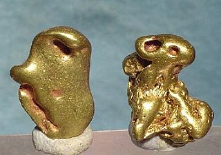
Mother lode is a principal vein or zone of gold or silver ore. The term is also used colloquially to refer to the real or imaginary origin of something valuable or in great abundance.

Kennecott, also known as Kennicott and Kennecott Mines, is an abandoned mining camp in the Copper River Census Area in the U.S. state of Alaska that was the center of activity for several copper mines. It is located beside the Kennicott Glacier, northeast of Valdez, inside Wrangell-St. Elias National Park and Preserve. The camp and mines are now a National Historic Landmark District administered by the National Park Service.

Hatcher Pass is a mountain pass through the southwest part of the Talkeetna Mountains, Alaska. It is named after Robert Hatcher, a prospector and miner. The nearest cities are Palmer and Wasilla approximately 12 miles (19 km) to the south, and Willow approximately 26 mi (42 km) to the west. The communities are at an elevation of approximately 250 ft (76 m) in the Mat-Su valley.

The Treadwell gold mine was on the south side of Douglas Island, .5-mile (0.80 km) east of downtown Douglas and southeast of downtown Juneau, owned and operated by John Treadwell. Composed of four sub-sites, Treadwell was in its time the largest hard rock gold mine in the world, employing over 2,000 people. Between 1881 and 1922, over 3 million troy ounces of gold were extracted. Not much remains today except for a few crumbling buildings and a "glory hole". Although John Treadwell had twelve years of experience in both placer and lode mines, he was a carpenter and builder by trade who had come to Alaska prior to the Klondike Gold Rush.
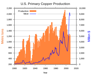
Copper mining in the United States has been a major industry since the rise of the northern Michigan copper district in the 1840s. In 2017 the United States produced 1.27 million metric tonnes of copper, worth $8 billion, making it the world's fourth largest copper producer, after Chile, China, and Peru. Copper was produced from 23 mines in the US. Top copper producing states in 2014 were Arizona, Utah, New Mexico, Nevada, and Montana. Minor production also came from Idaho, and Missouri. As of 2014, the US had 45 million tonnes of known remaining reserves of copper, the fifth largest known copper reserves in the world, after Chile, Australia, Peru, and Mexico.

Gold mining in the United States has taken place continually since the discovery of gold at the Reed farm in North Carolina in 1799. The first documented occurrence of gold was in Virginia in 1782. Some minor gold production took place in North Carolina as early as 1793, but created no excitement. The discovery on the Reed farm in 1799 which was identified as gold in 1802 and subsequently mined marked the first commercial production.
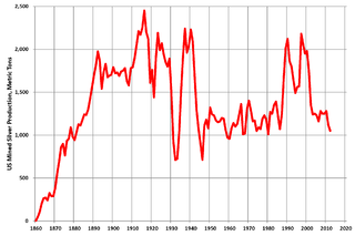
Silver mining in the United States began on a major scale with the discovery of the Comstock Lode in Nevada in 1858. The industry suffered greatly from the demonetization of silver in 1873 by the Coinage Act of 1873, known pejoratively as the "Crime of 73", but silver mining continues today.
Gold mining in Colorado, a state of the United States, has been an industry since 1858. It also played a key role in the establishment of the state of Colorado.
Silver mining in Nevada, a state of the United States, began in 1858 with the discovery of the Comstock Lode, the first major silver-mining district in the United States. Nevada calls itself the "Silver State." Nevada is the nation's second-largest producer of silver, after Alaska. In 2014 Nevada produced 10.93 million troy ounces of silver, of which 6.74 million ounces were as a byproduct of the mining of gold. The largest byproducers were the Hycroft Mine, the Phoenix Mine, the Midas Mine and Round Mountain.
Gold mining in Alaska, a state of the United States, has been a major industry and impetus for exploration and settlement since a few years after the United States acquired the territory in 1867 from the Russian Empire. Russian explorers discovered placer gold in the Kenai River in 1848, but no gold was produced. Gold mining started in 1870 from placers southeast of Juneau, Alaska.
Gold was discovered in the Yentna Cache-Creek Mining District in the US state of Alaska of the upper Susitna Valley in 1898, soon followed by claim staking. Placer mining was reported in the Cache Creek drainage of the Dutch Hills by 1906. Quaternary glaciofluvial deposits, alluvial deposits, and Cenozoic conglomeratic white quartz-breccia units have been mined in the Dutch Hills. About 200,000 oz of gold has been produced from these placer deposits.
The Willow Creek mining district, also known as the Independence Mine/Hatcher Pass district, is a gold-mining area in the U.S. state of Alaska. Underground hard-rock mining of gold from quartz veins accounts for most of the mineral wealth extracted from the Hatcher Pass area. The first mining efforts were placer mining of stream gravels, and placer mining in the area has continued sporadically to this day. Robert Hatcher discovered gold and staked the first claim in the Willow Creek valley in September 1906. The first lode mill in the area started operating in 1908. Underground mining continued at a variety of locations around the pass until 1951. In the 1980s one of the area's hard-rock mines was briefly re-opened. At least one mining company is actively exploring for gold in the area now. Through 2006 the district produced 667-thousand ounces of hard rock gold and 60-thousand ounces of placer gold.
The Juneau mining district is a gold mining area in the U.S. state of Alaska.
The Admiralty mining district is a mining area in the U.S. state of Alaska which consists of Admiralty Island. Silver and base metals are mined, with gold recovered as a by-product.

Kantishna is an unincorporated community in Denali Borough, Alaska, United States, within Denali National Park and Preserve. Founded as a gold mining camp in 1905, it endured longer than similar communities in the area, having been constructed nearest to the source of the gold. It lies in the Kantishna Hills at the junction of Eureka Creek and Moose Creek, 3 mi (5 km) northwest of Wonder Lake, and near the mouth of the Kantishna River. Although the community was once also called "Eureka", the Board on Geographic Names officially ruled in favor of "Kantishna" in 1944, the name given to the post office that was built at the site in 1905. Its elevation is 1,696 feet (517 m).
The South Pass greenstone belt is located within the Wyoming craton in the US. The region was the site of Wyoming's initial gold discovery in 1842.

The Silver Bow Basin, often written as Silverbow Basin, is a valley located 2.4 miles (3.9 km) northeast of Juneau, Alaska, USA. It is situated on Gold Creek in an area north of Icy Gulch, and approximately 1.5 miles (2.4 km) north of Gastineau Peak. A trail from Juneau leads directly to the mountainside. The basin was the site of the earliest gold discovery in the Juneau area, leading to the establishment of the town called Juneau.

The Alaska-Juneau Gold Mining Company (AJGMC) was incorporated under the laws of West Virginia, USA in 1897. Its lode mining claims covered approximately 402.37 acres (162.83 ha) on the wide vein called the Juneau gold belt of which it owned one mile on the outcrop.

Berners Bay is a waterway in the U.S. state of Alaska, approximately 40 miles (64 km) north of Juneau. It is a large and deep indentation, about 3.5 miles (5.6 km) wide at the entrance, which is formed by Point Bridget and Point St. Marys. It runs in a north-northwest direction for 6 miles (9.7 km) from Point Bridget, with a width of 3 miles (4.8 km) opposite Point St. Marys. The bay is surrounded by Tongass National Forest.
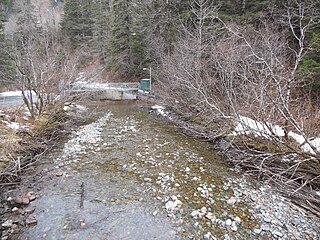
Gold Creek is a waterway in the southeastern section of the U.S. state of Alaska. It is located in Silver Bow Basin at the edge of Juneau. In 1880, Chief Kowee revealed to prospectors Joe Juneau and Richard Harris the presence of gold in Gold Creek; the city of Juneau was founded in the same year. Named by miners, the name was first published in 1883.


