Sheep Creek (Juneau, Alaska)

Last updated
Sheep Creek (Juneau, Alaska)
Sheep Creek
Thane, February 13, 2011 009.jpg
Sheep Creek Hatchery, as seen from beneath the bridge carrying Thane Road over Sheep Creek
Relief map of USA Alaska.png
Red pog.svg
Location of the mouth of Sheep Creek in Alaska
Location
Country United States
State Alaska
Physical characteristics
Source 
 - coordinates 58°15′40″N134°19′23″W / 58.26111°N 134.32306°W / 58.26111; -134.32306
Length3.5 km (2.2 mi)
Basin size5 km2 (1.9 sq mi)
Geologic map of the Sheep Creek area (lower right) Douglas geologic map.PNG
Geologic map of the Sheep Creek area (lower right)
Sheep Creek map showing gold prospects Sheep Creek map.PNG
Sheep Creek map showing gold prospects

Sheep Creek is located 4 miles (6.4 km) southeast of Juneau, in the U.S. state of Alaska. The Juneau community of Thane was originally called Sheep Creek. Draining an area of about 5 square miles (13 km2), it empties into Gastineau Channel. The valley formed by the river has a flat, gravel, trekking trail of 3.5 miles (5.6 km), south of Mount Roberts. The Snettisham hydroelectric dam substation is situated on a trail spur. Sheep Creek Hatchery is located at the outflow.

U.S. state constituent political entity sharing sovereignty as the United States of America

In the United States, a state is a constituent political entity, of which there are currently 50. Bound together in a political union, each state holds governmental jurisdiction over a separate and defined geographic territory and shares its sovereignty with the federal government. Due to this shared sovereignty, Americans are citizens both of the federal republic and of the state in which they reside. State citizenship and residency are flexible, and no government approval is required to move between states, except for persons restricted by certain types of court orders. Four states use the term commonwealth rather than state in their full official names.

Alaska State of the United States of America

Alaska is a U.S. state in the northwest extremity of North America, just across the Bering Strait from Asia. The Canadian province of British Columbia and territory of Yukon border the state to the east, its most extreme western part is Attu Island, and it has a maritime border with Russia to the west across the Bering Strait. To the north are the Chukchi and Beaufort seas—southern parts of the Arctic Ocean. The Pacific Ocean lies to the south and southwest. It is the largest state in the United States by area and the seventh largest subnational division in the world. In addition, it is the 3rd least populous and the most sparsely populated of the 50 United States; nevertheless, it is by far the most populous territory located mostly north of the 60th parallel in North America: its population—estimated at 738,432 by the United States Census Bureau in 2015— is more than quadruple the combined populations of Northern Canada and Greenland. Approximately half of Alaska's residents live within the Anchorage metropolitan area. Alaska's economy is dominated by the fishing, natural gas, and oil industries, resources which it has in abundance. Military bases and tourism are also a significant part of the economy.

Thane, Juneau Place in Alaska, United States

Thane is a neighborhood in the City and Borough of Juneau in the U.S. state of Alaska. Located along Gastineau Channel, it begins one mile (1.6 km) south of downtown Juneau and consists of approximately two dozen houses spread over five miles (8 km). All the houses are located on Thane Road, which comes to a dead end about six miles (10 km) from downtown; there are no side streets. It was named for Bartlett L. Thane, Manager and Director of the Alaska-Gastineau Mining Company.

Contents

Geography

Sheep Creek raises from the Sheep Mountain at an elevation of 4,238 feet (1,292 m). [1] Flowing from the water parting next to Grindstone Creek, the course of the main valley runs from southeast to northwest. About 2 miles (3.2 km) from its head, the stream makes a broad turn and in the lower 1.5 miles (2.4 km), flows toward the southwest. The total length of the river valley is about 3.5 miles (5.6 km). The upper and lower thirds of its course have steep grades, but the middle course is over a gravel flat sloping from 700–550 feet (210–170 m) elevation. Below the gravel flat, the tributary slopes are very narrow and there are no side gulches. Practically all of the drainage comes into the upper basin, where the walls of the valley are steep, though up to an elevation of about 1,800 feet (550 m), they are covered with alder brush and grass, and are generally sodded nearly to the summit of the surrounding ridges. The latter are nowhere more than 1 mile (1.6 km) distant from the stream, though they rise to elevations of from 2,500–3,800 feet (760–1,160 m). The generally smooth, but somewhat corrugated character of the slopes points to the molding action of ice, and the recency of glaciation is indicated by the shallowness of the rills, which collect the drainage from the mountain sides. [2]

The gravel trail is 3.5 miles (5.6 km) in length and provides access to the Mount Juneau Trail, the Granite Creek Trail and the Red Mill Trail and also many spur trails that lead to view locations and to mine ruins of historic value. The trail is wide and is in gravel formations and hence is not slippery as in the case of mud formed trails, and easy to access. [3]

Mount Juneau mountain

Mount Juneau is a 3,576-foot (1,090 m) massif in Southeast Alaska just one and a half miles east of downtown Juneau, Alaska, in the Boundary Ranges.

Geology

The formations of Gold Creek extend without interruption southeastward to Taku Inlet, but only the two outer divisions—namely, the black slate and the group of green stones and intercalated slate—are cut by Sheep Creek. On the ridge between Gold and Sheep creeks, the band of slates with their intrusive dikes of dark diorite is about 6,800 feet (2,100 m) across and this width is only slightly diminished in the vicinity of the Grindstone Creek divide, 3.5 miles (5.6 km) distant. The black slates contain dikes of dark diorite (altered gubbro), which follow the general trend of the formation. However, these rocks have not been greatly affected by vein waters. On the southeast ridge of Sheep Mountain and extending southeastward for 1.5 miles (2.4 km) is a somewhat irregular dike of the Coast Range-type of diorite. This rock has been impregnated to a certain extent by sulphides and locally contains stringers of quartz. This intrusion cuts a dike of the dark diorite. [2]

Gold Creek (Juneau, Alaska)

Gold Creek is a waterway in the southeastern section of the U.S. state of Alaska. It is located in Silver Bow Basin at the edge of Juneau. In 1880, Chief Kowee revealed to prospectors Joe Juneau and Richard Harris the presence of gold in Gold Creek; the city of Juneau was founded in the same year. Named by miners, it was first published in 1883.

Taku Inlet

Taku Inlet is an inlet located in the U.S. state of Alaska. It extends 18 miles (29 km) in a northeast direction from Stephens Passage in the Alexander Archipelago, about 12 kilometres (7.5 mi) southeast of Juneau, widening to a basin where discharge from the Taku River and Taku Glacier emerges.

Slate A fine-grained, foliated, homogeneous, weakly metamorphic rock

Slate is a fine-grained, foliated, homogeneous metamorphic rock derived from an original shale-type sedimentary rock composed of clay or volcanic ash through low-grade regional metamorphism. It is the finest grained foliated metamorphic rock. Foliation may not correspond to the original sedimentary layering, but instead is in planes perpendicular to the direction of metamorphic compression.

Flora and fauna

Notable flora reported are berries on which the bears feed in the entire valley, wild geranium, columbine, Dodecatheon, or "shooting stars", Fritillaria affinis or "chocolate lilies", blueberry and salmonberry bushes. [3]

<i>Aquilegia</i> genus of plants

Aquilegia is a genus of about 60–70 species of perennial plants that are found in meadows, woodlands, and at higher altitudes throughout the Northern Hemisphere, known for the spurred petals of their flowers.

<i>Dodecatheon</i> genus of plants

Dodecatheon is a genus of herbaceous flowering plants in the family Primulaceae. The species have basal clumps of leaves and nodding flowers that are produced at the top of tall stems rising from where the leaves join the crown. The genus is largely confined to North America and part of northeastern Siberia. Common names include shooting star, American cowslip, mosquito bills, mad violets, and sailor caps. A few species are grown in gardens for their showy and unique flower display.

<i>Fritillaria affinis</i> species of plant


Fritillaria affinis is a highly variable species in the genus Fritillaria, native to western North America, in California, Klamath Ranges, the north coast ranges, Cascade Ranges, north Sierra Nevada foothills, and the San Francisco Bay Area, north to British Columbia, Oregon, Washington, Montana and Idaho.

The fauna reported in the valley are: Mountain goats and black bear. During late summer, chum salmon (also called dog) Oncorhynchus keta fully clog the stream waters from bank to bank, and is popular location to witness the fishes and also do fishing in the stream. [4] Sheep Creek Hatchery was established in 1980 with the objective of incubating about 40 million pink and/or chum salmon for use in commercial fisheries. [5] The Coho Annex facility became part of this hatchery as the coho brood stock source. In the following years, this expanded into the Macaulay Salmon Hatchery, which is now the coho rearing facility. [5]

American black bear species of bear

The American black bear is a medium-sized bear native to North America. It is the continent's smallest and most widely distributed bear species. American black bears are omnivores, with their diets varying greatly depending on season and location. They typically live in largely forested areas, but do leave forests in search of food. Sometimes they become attracted to human communities because of the immediate availability of food. The American black bear is the world's most common bear species.

Chum salmon species of fish

The chum salmon is a species of anadromous fish in the salmon family. It is a Pacific salmon, and may also be known as dog salmon or keta salmon, and is often marketed under the name silverbrite salmon. The name chum salmon comes from the Chinook Jargon term tzum, meaning "spotted" or "marked", while keta in the scientific name comes from the Evenki language of Eastern Siberia via Russian.

See also

Related Research Articles

Turnagain Arm

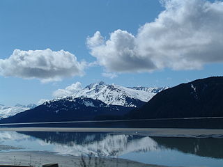
Turnagain Arm is a waterway into the northwestern part of the Gulf of Alaska. It is one of two narrow branches at the north end of Cook Inlet, the other being Knik Arm. Turnagain is subject to climate extremes and large tide ranges.

Waddell Creek (California) river in the United States of America

Waddell Creek is the name given to both the creek and the watershed that run through Big Basin Redwoods State Park in Santa Cruz County, California. The Waddell Creek mainstem is formed by the confluence of East and West Waddell Creeks, and empties into the Pacific Ocean at Waddell Beach, just south of Año Nuevo Point.

Hatcher Pass mountain pass

Hatcher Pass, also known as Hatcher's Pass, is a mountain pass through the southwest part of the Talkeetna Mountains, Alaska. It is named after Robert Hatcher, a prospector and miner. The nearest cities are Palmer and Wasilla approximately 12 miles (19 km) to the south, and Willow approximately 26 mi (42 km) to the west. The communities are at an elevation of approximately 250 ft (76 m) in the Mat-Su valley.

Silver Star Mountain (Skamania County, Washington)

Silver Star Mountain is an extinct volcano of the Cascade Range in the U.S. state of Washington. Consisting of late Eocene to Oligocene epoch rock, it lies within the Gifford Pinchot National Forest. Long inactive, the volcano sits over three lithologic units, including the large Silver Star Granodiorite unit.

Lagunitas Creek river in the United States of America

Lagunitas Creek is a 24 miles (39 km)-long northward-flowing stream in Marin County, California. It is critically important to the largest spawning runs of endangered coho salmon in the Central California Coast Coho salmon Evolutionary Significant Unit. The stream's headwaters begin on the northern slopes of Mt. Tamalpais in the Coast Range and terminate in southeast Tomales Bay, 1.5 miles (2.4 km) northwest of Point Reyes Station, California. Lagunitas Creek feeds several reservoirs on Mt. Tamalpais that supply a major portion of the county's drinking water.

Treadwell gold mine mine on Douglas Island, AK active 1881-1922

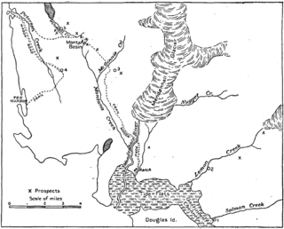
The Treadwell gold mine was on the south side of Douglas Island, .5-mile (0.80 km) east of downtown Douglas and southeast of downtown Juneau, owned and operated by John Treadwell. Composed of four sub-sites, Treadwell was in its time the largest hard rock gold mine in the world, employing over 2,000 people. Between 1881 and 1922, over 3 million troy ounces of gold were extracted. Not much remains today except for a few crumbling buildings and a "glory hole". Although John Treadwell had twelve years of experience in both placer and lode mines, he was a carpenter and builder by trade who had come to Alaska prior to the Klondike Gold Rush.

Dog Salmon River river in the United States of America

The Dog Salmon River is a 70-mile (110 km) tributary of the Ugashik River in the U.S. state of Alaska. Beginning on the flanks of Mount Kialagvik, it flows northwest through the Alaska Peninsula National Wildlife Refuge to meet the larger river 4 miles (6 km) southwest of Ugashik, at the head of Ugashik Bay, an arm of Bristol Bay.

Gold mining in Alaska Alaska Mining District

Gold mining in Alaska, a state of the United States, has been a major industry and impetus for exploration and settlement since a few years after the United States acquired the territory from Russia. Russian explorers discovered placer gold in the Kenai River in 1848, but no gold was produced. Gold mining started in 1870 from placers southeast of Juneau, Alaska.

Mossom Creek Hatchery is a salmon hatchery in Port Moody, British Columbia. It is a salmon enhancement project supported by Fisheries and Oceans Canada. It was started in 1976 by high school volunteers from local Centennial School in Coquitlam and teachers Ruth Foster and Rod MacVicar. They formed the Centennial School Salmon project, which is still an active club at the school. It has received much recognition for its unique and longstanding work. Ruth Foster has won a Canadian Environment Award for her work at Mossom Creek Hatchery.

Salmon Creek Dam

The Salmon Creek Dam is a concrete arch dam on the Salmon Creek, 3 miles (5 km) northwest of Juneau, Alaska. Built in 1914, it is the world's first constant-angle arch variable radius dam. Since it was built, over 100 such dams have been constructed all over the world.

Kowee Creek

Kowee Creek is a river on Douglas Island in the City and Borough of Juneau, Alaska, United States. Its origin is southeast of Mount Troy and it flows north-northeast to Gastineau Channel near West Juneau; it is 0.5 miles (0.80 km) southwest of the city of Juneau. Kowee Creek is nearly 10 miles (16 km) long. It has a drainage basin of about 50 square miles (130 km2) and two transverse tributaries.

Scott Creek (Santa Cruz County)

Scott Creek, also called Scotts Creek, is a 12.2-mile-long (19.6 km) stream and surfspot in Santa Cruz County, California. It is a few miles north of Davenport and a few miles south of Waddell Creek.

Windham Bay

Windham Bay is located 45 miles (72 km) southeast of Juneau, in the U.S. state of Alaska. Windham Bay is listed as site 6 within Southeast Alaska's Zone 3 of the Alaska Dept. of Environmental Conservation's Geographic Response Strategy oil spill response plan. Part of the bay is a protected wilderness area; the Chuck River Wilderness, established in 1990 by the United States Congress, covers an area of 74,506 acres (30,152 ha). The Chuck River flows into Windham Bay, which has a protected anchorage north of Port Houghton, where the historic Chuck Mining Camp once operated.

Nugget Creek is fed by the Nugget Glacier, a tributary glacier on the mountainside east of Auke Bay in the borough of Juneau, Alaska, US. The creek feeds Nugget Falls. The valley of Nugget Creek joins that of Mendenhall River about 1.5 miles (2.4 km) above the foot of the glacier. Its basin, about 3 miles (4.8 km) in length, trends east and west, and there are several tributary gulches which head against the Lemon Creek divide. The rocks of the valley belong to the group of schists which lies next to the main diorite, except at the headwaters, where the edge of the intrusive rock appears. The Nugget Mall, located at the opposite end of the Mendenhall Valley and Juneau's largest shopping mall, derives its name from the creek.

Lemon Creek (Alaska) river in the United States of America

Lemon Creek is a stream in the U.S. state of Alaska. It is primarily filled by the meltwater of Lemon Creek Glacier, as well as another glacier. The Lemon name is said to come from traveling miner John Lemon, who reportedly had a placer mine on the creek in 1879.

Juneau gold belt

The Juneau gold belt is located in the southeastern portion of the U.S. state of Alaska. This belt is approximately 100 miles (160 km) in length, north/northwest-trending, and extends from Berners Bay southeastward to Windham Bay, 60 miles (97 km) southeast of Juneau, and includes Douglas Island. The belt contains over 200 gold-quartz-vein deposits with production nearing 7,000,000 ounces (200,000,000 g) of gold. More than three-quarters of Alaska's lode gold was mined from the Juneau gold belt.

Kruzgamepa River river in the United States of America

The Kruzgamepa River is a 55-mile (89 km) tributary of the Kuzitrin River on the Seward Peninsula in the U.S. state of Alaska. The river begins at Salmon Lake, elevation 447 feet (136 m), and descends to 20 feet (6.1 m) above sea level at its mouth. In turn, the Kuzitrin River empties into the Imuruk Basin. The basin drains via the bay of Port Clarence to the Bering Sea.

Eureka Creek is a tributary of Baker Creek in the U.S. state of Alaska. Other Baker tributaries in the vicinity of Eureka Creek include Thanksgiving, Gold Run, and Pioneer creeks with Seattle Junior Creek a tributary of Pioneer.

Palmer Creek is a waterway in the Kenai Peninsula, Alaska, US. It is an affluent of Resurrection Creek, itself a tributary of Turnagain Arm.

References

This article contains public domain text from A.C. Spencer's "The Juneau gold belt, Alaska: A reconnaissance of Admiralty Island, Alaska" (1906)

  1. "Lonely Planet review for Sheep Creek Trail". Lonely Planet. Retrieved 12 January 2012.
  2. 1 2 Spencer, Arthur Coe; Wright, Charles L.; Wright, Charles Will (1906). The Juneau gold belt, Alaska: A reconnaissance of Admiralty Island, Alaska (Public domain ed.). Government Printing Office. pp. 48–56. Retrieved 11 January 2013.
  3. 1 2 "Sheep Creek Trail (Juneau Region)". Department of Natural Resources:Government of Alaska. Retrieved 12 January 2013.
  4. "Fish Viewing". Alaska Department of Fish and Game. Retrieved 12 January 2013.
  5. 1 2 "Sheep Creek Hatchery". Douglas Island Pink & Chum, Inc. Retrieved 12 January 2012.