Related Research Articles

Richland County is a county located in the U.S. state of South Carolina. As of the 2020 census, its population was 416,147, making it the second-most populous county in South Carolina, behind only Greenville County. The county seat and largest community is Columbia, the state capital. The county was established on March 12, 1785. Richland County is part of the Columbia, SC Metropolitan Statistical Area. In 2020, the center of population of South Carolina was located in Richland County, in the city of Columbia. The county is also the location of the geographic center of South Carolina, southeast of Columbia.

Newberry County is a county located in the U.S. state of South Carolina. As of the 2020 census, its population was 37,719. Its county seat is Newberry. The name is of unknown origin, although one theory suggests that it was named by Quaker settlers in honor of their home of Newberry, a suburb of London in the United Kingdom. Newberry County comprises the Newberry, SC Micropolitan Statistical Area.
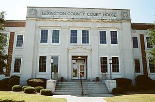
Lexington County is a county located in the U.S. state of South Carolina. As of the 2020 census, the population was 293,991. Its county seat and largest community is Lexington. The county was chartered in 1785 and was named in commemoration of Lexington, Massachusetts, the site of the Battle of Lexington in the American Revolutionary War. Lexington County is the sixth-most populous county in South Carolina by population and is part of the Columbia, SC Metropolitan Statistical Area. It is located in the Midlands region of South Carolina.

Guilford County is a county located in the U.S. state of North Carolina. As of the 2020 census, the population was 541,299, making it the third-most populous county in North Carolina. The county seat and largest community is Greensboro. Since 1938, an additional county court has been located in High Point. The county was formed in 1771. Guilford County is included in the Greensboro-High Point, NC Metropolitan Statistical Area, which is also included in the Greensboro–Winston-Salem–High Point, NC Combined Statistical Area.

Chapin, popularly known as the "Capital of Lake Murray", is a small lake town located at the northern tip of Lexington County, South Carolina, United States. Lake Murray separates Chapin from the rest of Lexington County. The population of Chapin was 1,445 according to the 2010 census, and an estimated 1,633 in 2019.

Little Mountain is a town in Newberry County, South Carolina, United States. The population was 291 at the 2010 census. The town took its name from nearby Little Mountain.

Newberry is a city in Newberry County, South Carolina, United States, in the Piedmont 43 miles northwest of Columbia. The charter was adopted in 1894. The population was 10,277 at the 2010 census. It is the county seat of Newberry County; at one time it was called Newberry Courthouse.

Pomaria is a town in Newberry County, South Carolina, United States. The population was 127 at the 2020 census.

Irmo is a town in Lexington and Richland counties, South Carolina, United States and a suburb of Columbia. It is part of the Columbia Metropolitan Statistical Area and is located 12 miles (19 km) northwest of the city center. The population of Irmo was 11,569 at the 2020 census.

The Midlands region of South Carolina is the middle area of the state. The region's main center is Columbia, the state's capital. The Midlands is so named because it is halfway point between the Upstate and the Lowcountry. The main area code is 803.
Lake Murray Country is a large area of South Carolina, United States; the region includes the counties of Newberry, Saluda, Lexington, and Richland. The towns of Lexington and Irmo are usually considered to be part of it.

The Broad River is a principal tributary of the Congaree River, about 150 miles (240 km) long, in western North Carolina and northern South Carolina in the United States. Via the Congaree, it is part of the watershed of the Santee River, which flows to the Atlantic Ocean.

Lake Murray is a reservoir in the U.S. state of South Carolina. It is approximately 50,000 acres in size, and has roughly 650 mi of shoreline. It was impounded in the late 1920s to provide hydroelectric power to the state of South Carolina. Lake Murray is fed by the Saluda River, which flows from upstate South Carolina near the North Carolina state line. The Saluda Dam was an engineering feat at the time of its construction. The dam, using the native red clay soil and bedrock, was the largest earthen dam in the world when it was completed in 1930. Lake Murray itself is named after the project's chief engineer, William S. Murray. The Saluda Dam is approximately 1.5 miles (2.4 km) long and 220 feet (67 m) high. Lake Murray is 41 miles (66 km) long, and 14 miles (23 km) wide at its widest point. At the time when the lake was finished, it was the world's largest man-made reservoir.
School District Five of Lexington and Richland Counties is a South Carolina school district encompassing a land area of approximately 196 square miles, (508 km2) roughly half of which is situated in each of Lexington and Richland Counties. Student enrollment is at 16,717 as of August 2005. The school district consists of the northern portion of Lexington County lying north of Lake Murray and the Saluda River and the northwestern portion of Richland County lying south of the Broad River. The School District is primarily a residential suburb located to the northwest of the city of Columbia, the capital city of South Carolina. Included in the District Five are the towns of Irmo and Chapin. The school district has three attendance areas: Chapin, Dutch Fork, and Irmo. District Five operates a total of 12 elementary schools, four middle schools, five high schools, and one alternative school. The interim Superintendent is Akil Ross, appointed in June 2021 following the sudden resignation of former superintendent Christina Melton at a board meeting on June 14 over conflicts with some school board members. The Chief of Academics and Administration is Anna Miller. The Current Board Chair is Rebecca Blackburn Hines.

The Saluda River is a principal tributary of the Congaree River, about 200 mi (320 km) long, in northern and western South Carolina in the United States. Via the Congaree River, it is part of the watershed of the Santee River, which flows to the Atlantic Ocean.
Ballentine is an unincorporated community in Richland County, South Carolina, United States. It is part of the Columbia, South Carolina metropolitan area.
Cherryville Township is a township in northwestern Gaston County, North Carolina, United States. As of the 2010 census it had a population of 16,500. It includes the incorporated city of Cherryville, the inactive incorporated town of Dellview, the unincorporated community of Tryon, and a portion of the town of High Shoals. It is represented on the Gaston County Board of Commissioners by Allen Fraley of Cherryville.

St. John Lutheran Church is a historic Lutheran congregation in Pomaria, South Carolina affiliated with the Evangelical Lutheran Church in America. It was listed on the National Register of Historic Places in 1978.

Birch County is a proposal to establish a county in the Midlands region of South Carolina.The county would comprise portions of northern Lexington County and northwestern portions of Richland County, including the communities of Ballentine, Irmo, and Chapin. The proposed county's name would have been derived from the first letters of these communities, Ballentine, Irmo, and Chapin. This would have been the "illegal" 47th county in the state, as state law currently stipulates that South Carolina can have no more than 46 counties.
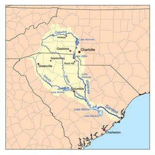
The Tyger River is a stream in the U.S. state of South Carolina, and a tributary of the Broad River. It is part of the Santee River Basin. It is a generally shallow and narrow river. Pollution in the north fork was the source of dispute in Friends of the Earth, Inc. v. Laidlaw Environmental Services, Inc.
References
- ↑ "Archived copy". Archived from the original on 2006-06-30. Retrieved 2006-07-05.
{{cite web}}: CS1 maint: archived copy as title (link)