
Oxbow is an unincorporated community in Baker County, Oregon, United States. Oxbow is along Oregon Route 86 next to the Snake River near the Oxbow Dam on the Oregon-Idaho border, about 17 miles (27 km) northeast of Halfway. Oxbow is just south of the site of the former mining town of Copperfield. Oxbow has a post office with a ZIP code 97840.

Old Mission is an unincorporated community in Grand Traverse County in the U.S. state of Michigan. The community is located within Peninsula Township, and is located about 2 miles (3.2 km) south of the tip of the Old Mission Peninsula, along the shore of the East Arm of Grand Traverse Bay. As an unincorporated community, Old Mission has no legally defined boundaries or population statistics of its own.

Eagle Creek is an unincorporated community in Clackamas County, Oregon, United States. It is located seven miles southwest of Sandy, seven miles north of Estacada, and five miles southeast of Carver, at the junction of Oregon Routes 224 and 211, on the Clackamas River.

Buxton is an unincorporated community in Washington County, Oregon, United States, near Oregon Route 47.

Timber is an unincorporated community in Washington County, Oregon, United States. Timber's population is 131, its ZIP code is 97144, it has 59 housing units and its land area is 17.45 sq mi (45.2 km2), with a population density of 7.51/sq mi (2.90/km2).
Fox is an unincorporated community in Grant County, Oregon, United States, on U.S. Route 395 south of Long Creek.

Trail is a census-designated place and unincorporated community in Jackson County, Oregon, United States. As of the 2010 census it had a population of 702. It has a post office with a ZIP code of 97541.
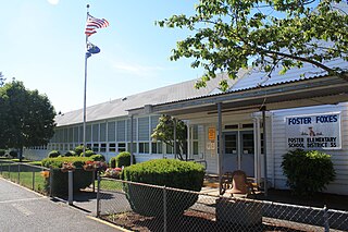
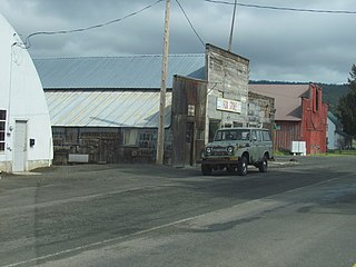
Foster is an unincorporated community partly within the city of Sweet Home in Linn County, Oregon. It is located on the western end of the Foster Reservoir. A post office named Foster serves ZIP code 97345, which serves areas beyond the Sweet Home city limits on both the north and south sides of Foster Lake: on the north side, the area extends along the Middle Santiam River to the west end of Green Peter Lake; on the south, the area extends for several miles along the South Santiam River and U.S. Route 20.

Curtin is an unincorporated community in Douglas County, Oregon, United States. It is on Interstate 5 and the former Southern Pacific railroad line about 7 miles (11 km) northeast of Drain along Pass Creek. It stands at an elevation of 404 feet.

Piercy is an unincorporated community in Mendocino County, California. It is located on the South Fork of the Eel River, 9 miles (14 km) north-northwest of Leggett, at an elevation of 794 feet (242 m).
Broadbent is an unincorporated community in Coos County, Oregon, United States. Broadbent is on Oregon Route 542 south of Myrtle Point along the South Fork Coquille River. Broadbent has a post office with ZIP code 97414.
Idleyld Park is an unincorporated community in Douglas County, Oregon, United States. Idleyld Park is located along Oregon Route 138 northeast of Glide. Idleyld Park has a post office with ZIP code 97447.
Somes Bar or Sommes Bar, is an unincorporated community in Siskiyou County, California, United States. Somes Bar is located on the Salmon River 12 miles (19 km) northwest of Forks of Salmon. Somes Bar has a post office with ZIP code 95568, which opened in 1875. Somes Bar is named after George Somes, who found gold in the area in 1850. It was first located within Klamath County, California until it was absorbed by Siskiyou County when Klamath County was dissolved.

Monitor is a small unincorporated community in Chelan County, Washington, United States. It is situated along the Wenatchee River about 8 miles upstream from its junction with the Columbia River in the fertile Wenatchee Valley.
Kaweah is an unincorporated community in Tulare County, California, United States. Kaweah is 2 miles (3.2 km) north-northwest of Three Rivers. Kaweah has a post office with ZIP code 93237.

Callahan is an unincorporated community in Siskiyou County, California, United States. Callahan is located on California State Route 3 11.5 miles (18.5 km) south-southeast of Etna. Callahan has a post office with ZIP code 96014. As of 2009 it has a population of 50~.

De Smetdə SMET or dez-MET; is a census-designated place on the Coeur d'Alene Reservation in Benewah County, Idaho, United States.
Seahurst is an unincorporated community in King County, Washington, United States. Seahurst is located on Puget Sound west of Burien. Seahurst has a post office with ZIP code 98062.

La Grande is an unincorporated community and census-designated place in Pierce County, Washington, United States. La Grande is located along Washington State Route 7 3.5 miles (5.6 km) southwest of Eatonville. La Grande has a post office with ZIP code 98348.

Lakebay is an unincorporated community in Pierce County, Washington, United States. Lakebay is located at the head of Mayo Cove on the east side of the Key Peninsula, 1 mile (1.6 km) south of Home. Lakebay has a post office with ZIP code 98349.

