Fife, Washington

Last updated
Fife, Washington
Pierce County Washington Incorporated and Unincorporated areas Fife Highlighted.svg
Location of Fife, Washington
Coordinates: 47°14′4″N122°21′35″W / 47.23444°N 122.35972°W / 47.23444; -122.35972 Coordinates: 47°14′4″N122°21′35″W / 47.23444°N 122.35972°W / 47.23444; -122.35972
CountryUnited States
State Washington
County Pierce
Government
  Type Council–manager [1]
  MayorKim Roscoe
Area
[2]
  Total5.89 sq mi (15.25 km2)
  Land5.76 sq mi (14.91 km2)
  Water0.13 sq mi (0.34 km2)
Elevation
23 ft (7 m)
Population
 (2020) [3]
  Total10,999
  Density1,900/sq mi (720/km2)
Time zone UTC-8 (Pacific (PST))
  Summer (DST) UTC-7 (PDT)
ZIP code
98424
Area code 253
FIPS code 53-23795
GNIS feature ID1512206 [4]
Website cityoffife.org

Fife is a city in Pierce County, Washington, United States and a suburb of Tacoma. The population was 10,999 at the 2020 census. [3] Fife is contained within the Puyallup Indian Reservation.

Contents

History

The lower Puyallup basin is the ancestral home of the Puyallup people, who were relocated after the signing of the Medicine Creek Treaty in 1854. The treaty ceded Puyallup lands and created the Puyallup Indian Reservation, which was expanded to include modern-day Fife. The land on which the city sits was lost after the signing of the General Allotment Act in 1887 and other land transfers that were later resolved in a 1990 claims settlement. [5]

In 1940, Fife was described as "at a valley crossroads in the midst of a thickly settled berry growing and truck-gardening district is represented by a string of markets, taverns, shops, and a large, balloon-roofed dance hall along the highway." The 1940 population was 135. [6] Fife was officially incorporated on February 11, 1957.

Due to the increased traffic volume traveling from Puyallup and Tacoma, Fife felt the need to establish itself as autonomous community, not just as an intermediate area between Interstate 5 (I-5) and State Route 167.

Fife may have been named for William J. Fife, a prominent Tacoma lawyer, Yukon prospector, once head of the Washington National Guard, and a lieutenant colonel in the field during the Philippine Insurrection. [7] There is also a historic county of Scotland and former Pictish kingdom called Fife, which could also be a source of the city's name.

Economy

Fife, an eastern suburb of Tacoma, consists primarily of businesses such as car dealerships, warehousing and industrial facilities, motels, drive through smoke shops, quick-dining restaurants as well as a Native American casino and various other highway-side businesses. Its proximity to the Port of Tacoma, Interstate 5, and Highway 167 has contributed to the large number of freight forwarding companies. Fife's tax base is made up of sales tax, utility tax, and property tax. [8] Fife Heights, located on a hill beyond the incorporated bounds of the city, is a primarily residential area. Milton is located immediately to the east and Edgewood to the southeast.

Geography

Fife is located at 47°14′4″N122°21′35″W / 47.23444°N 122.35972°W / 47.23444; -122.35972 (47.234439, -122.359690). [9] It is entirely within the Puyallup Indian Reservation created in 1854, but title is held almost entirely by non-Native Americans. [10] [11]

According to the United States Census Bureau, the city has a total area of 5.83 square miles (15.10 km2), of which 5.69 square miles (14.74 km2) is land and 0.14 square miles (0.36 km2) is water. [12]

Fife is also a tideflat community, residing in the low, flat area extending from the Port of Tacoma. This means the water table occurs only 10–15 feet (3.0–4.6 m) below ground in some parts. Consequently, during the day, as the tide rises and falls in the Puget Sound, so do parts of land slightly rise and fall.

The southern portions of the city are in the floodplain of the Puyallup River. Much of the city would be damaged or destroyed in the event of a lahar due to an eruption of Mount Rainier.

Demographics

Historical population
CensusPop.Note
1960 1,463
1970 1,458−0.3%
1980 1,82325.0%
1990 3,864112.0%
2000 4,78423.8%
2010 9,17391.7%
2020 10,99919.9%
U.S. Decennial Census [13]
2020 Census [3]

2010 census

At the census of 2010, [14] there were 9,173 people, 3,642 households, and 2,192 families living in the city. The population density was 1,612.1 inhabitants per square mile (622.4/km2). There were 3,895 housing units at an average density of 684.5 per square mile (264.3/km2). The racial makeup of the city was 55.2% White, 8.2% African American, 3.0% Native American, 15.5% Asian, 2.7% Pacific Islander, 7.6% other races, and 7.8% from two or more races. Hispanic or Latino of any race were 17.4%.

Of the 3,642 households 35.4% had children under the age of 18 living with them, 39.8% were married couples living together, 13.7% had a female householder with no husband present, 6.6% had a male householder with no wife present, and 39.8% were non-families. 29.7% of households were one person and 4.2% were one person aged 65 or older. The average household size was 2.50 and the average family size was 3.12.

The median age was 30.9 years. 25.7% of residents were under the age of 18; 10.5% were between the ages of 18 and 24; 36.9% were from 25 to 44; 20.4% were from 45 to 64; and 6.5% were 65 or older. The gender makeup of the city was 50.4% male and 49.6% female.

2000 census

At the census of 2000, there were 4,784 people, 2,111 households, and 1,123 families living in the city. The population density was 859.7 people per square mile (332.2/km2). There were 2,232 housing units at an average density of 401.1 per square mile (155.0/km2). The racial makeup of the city was 68.62% White, 6.81% African American, 4.14% Native American, 6.50% Asian, 1.23% Pacific Islander, 6.94% from other races, and 5.75% from two or more races. Hispanic or Latino of any race were 13.55% of the population.

Of the 2,111 households 30.4% had children under the age of 18 living with them, 32.4% were married couples living together, 14.4% had a female householder with no husband present, and 46.8% were non-families. 37.5% of households were one person and 6.6% were one person aged 65 or older. The average household size was 2.24 and the average family size was 3.00.

The age distribution was 25.8% under the age of 18, 14.4% from 18 to 24, 34.9% from 25 to 44, 17.3% from 45 to 64, and 7.5% 65 or older. The median age was 29 years. For every 100 females, there were 106.7 males. For every 100 females age 18 and over, there were 106.3 males.

The median household income was $31,806 and the median family income was $36,250. Males had a median income of $30,963 versus $25,101 for females. The per capita income for the city was $16,723. About 12.6% of families and 14.9% of the population were below the poverty line, including 19.8% of those under age 18 and 7.9% of those age 65 or over.

Education

Fife branch of the Pierce County Library system Pierce County Library - Fife 01.jpg
Fife branch of the Pierce County Library system

The majority of the city limits is in the Fife Public Schools, which also includes Milton and parts of Edgewood. [15] The district has one high school, Fife High School.

Other parts of Fife are in the Puyallup School District. [15]

Notable people

Related Research Articles

<span class="mw-page-title-main">Pierce County, Washington</span> County in Washington, United States

Pierce County is a county in the U.S. state of Washington. As of the 2020 census, the population was 921,130, up from 795,225 in 2010, making it the second-most populous county in Washington, behind King County, and the 60th-most populous in the United States. The county seat and largest city is Tacoma. Formed out of Thurston County on December 22, 1852, by the legislature of Oregon Territory, it was named for U.S. President Franklin Pierce. Pierce County is in the Seattle metropolitan area.

<span class="mw-page-title-main">South Beach, Florida</span> Census-designated place in Florida, United States

South Beach is a census-designated place (CDP) on North Hutchinson Island in Indian River County, Florida, United States. The population was 3,501 at the 2010 census. It is ranked tenth in Florida locations by per capita income as of 2010.

<span class="mw-page-title-main">Coleraine, Minnesota</span> City in Minnesota, United States

Coleraine is a city in Itasca County, Minnesota, United States. The population was 1,970 at the 2010 census. The community was named after Thomas F. Cole, President of the Oliver Iron Mining Company.

<span class="mw-page-title-main">Mound City, South Dakota</span> Town in South Dakota, United States

Mound City is a town in and the county seat of Campbell County, South Dakota, United States. The population was 69 at the 2020 census.

<span class="mw-page-title-main">Flandreau, South Dakota</span> City in South Dakota, United States

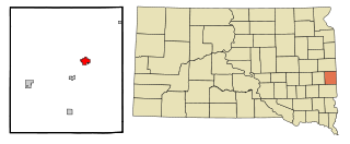
FlandreauFLAN-droo is a city in and county seat of Moody County, South Dakota, United States. The population was 2,372 at the 2020 census. It was named in honor of Charles Eugene Flandrau, a judge in the territory and state of Minnesota. He is credited with saving the community of New Ulm, Minnesota, from destruction during conflict with the Sioux tribe in 1862.

<span class="mw-page-title-main">Mission, South Dakota</span> City in South Dakota, United States

Mission is a city on the Rosebud Indian Reservation in northern Todd County, South Dakota, United States. The population was 1,156 at the 2020 census.

<span class="mw-page-title-main">Normandy Park, Washington</span> City in Washington, United States

Normandy Park is a city in King County, Washington, United States. The population was 6,771 at the 2010 census.

<span class="mw-page-title-main">Eatonville, Washington</span> Town in Washington, United States

Eatonville is a town in Pierce County, Washington, United States. It is 32 mi (51 km) south of Tacoma. The population was 2,845 at the 2020 census. The town motto is "Better Together".

<span class="mw-page-title-main">Edgewood, Washington</span> City in Washington, United States

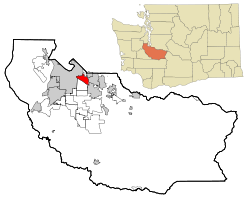
Edgewood is a city in Pierce County, Washington, United States. The population was 12,327 at the 2020 census. Neighboring towns include Fife to the west, Milton to the northwest, Federal Way to the north, Sumner to the east, and Puyallup to the south.

<span class="mw-page-title-main">Elk Plain, Washington</span> CDP in Washington, United States

Elk Plain is a census-designated place (CDP) in Pierce County, Washington, United States. The population was 14,205 at the 2010 census.

<span class="mw-page-title-main">Graham, Washington</span> CDP in Washington, United States

Graham is a census-designated place (CDP) in Pierce County, Washington, United States. It is located 16 miles southeast of Tacoma. The population was 23,491 at the 2010 census and grew to 32,658 at the 2020 census.

<span class="mw-page-title-main">Midland, Washington</span> CDP in Washington, United States

Midland is a census-designated place (CDP) in Pierce County, Washington. The population was 7,414 at the time of the 2000 census.

<span class="mw-page-title-main">Orting, Washington</span> City in Washington, United States

Orting is a city in Pierce County, Washington, United States. The population was 9,041 at the 2020 census.

<span class="mw-page-title-main">Puyallup, Washington</span> City in Washington, United States

Puyallup is a city in Pierce County, Washington, United States, located about 10 miles southeast of Tacoma and 35 miles south of Seattle. It had a population of 42,973 at the 2020 census. The city's name comes from the Puyallup Tribe of Native Americans and means "the generous people". Puyallup is also home to the Washington State Fair, the state's largest fair.

<span class="mw-page-title-main">Roy, Washington</span> City in Washington, United States

Roy is a city in Pierce County, Washington, United States. The population was 816 at the 2020 census.

<span class="mw-page-title-main">Ruston, Washington</span> Town in Washington, United States

Ruston is a city in Pierce County, Washington, United States. The population was 1,055 at the 2020 census.

<span class="mw-page-title-main">South Hill, Washington</span> CDP in Washington, United States

South Hill is a census-designated place (CDP) in Pierce County, Washington, immediately south of Puyallup. The population was 64,708 at time of the 2020 census, up from 52,431 in 2010. The area primarily consists of suburban housing and shopping with several retail shopping centers, residential neighborhoods, and apartment/condo complexes throughout.

<span class="mw-page-title-main">Sumner, Washington</span> City in Washington, United States

Sumner is a city in northern Pierce County, Washington, United States. The population was 10,621 at the 2020 census. Nearby cities include Puyallup to the west, Auburn to the north, and Bonney Lake to the east.

<span class="mw-page-title-main">Milton, Washington</span> City in Washington, United States

Milton is a city in King and Pierce counties in the U.S. state of Washington. The population was 8,697 at the time of the 2020 census. Milton borders the larger but newer town of Edgewood.

<span class="mw-page-title-main">Pacific, Washington</span> City in Washington, United States

Pacific is a city in King and Pierce counties in the State of Washington. Located primarily in King County, the population was 7,235 at the 2020 census.

References

  1. "City Government". City of Fife. Retrieved April 2, 2022.
  2. "2019 U.S. Gazetteer Files". United States Census Bureau. Retrieved August 7, 2020.
  3. 1 2 3 "2020 Census Redistricting Data (Public Law 94-171) Summary File". American FactFinder. United States Census Bureau . Retrieved May 16, 2022.
  4. "US Board on Geographic Names". United States Geological Survey. October 25, 2007. Retrieved January 31, 2008.
  5. Douglas, Miguel (October 12, 2016). "Puyallup Land Claims Settlement (1990)". HistoryLink . Retrieved September 27, 2020.
  6. Washington - A guide to the Evergreen State, WPA American Guide Series, Washington State Historical Society, 1941
  7. Denyer Gallacci, Caroline; Karabaich, Ron (2009). Downtown Tacoma. Images of America. Arcadia Publishing. p. 11. ISBN   978-0-7385-7002-0. OCLC   436871566.
  8. "City of Fife Budget" City Staff, 2012 http://www.cityoffife.org/index.php?p=city_departments&a=finance&b=budgets Archived August 7, 2011, at the Wayback Machine
  9. "US Gazetteer files: 2010, 2000, and 1990". United States Census Bureau. February 12, 2011. Retrieved April 23, 2011.
  10. George Hardeen (March 24, 1990). "Tribe to Sign Land Settlement Pact : Indian claims: Puyallup members will share $162 million for relinquishing interest in acreage in Tacoma area". The Los Angeles Times.
  11. Puyallup Tribe of Indians Street Map (PDF) (Map). Puyallup Tribe of Indians. January 2017. Retrieved April 21, 2020.
  12. "US Gazetteer files 2010". United States Census Bureau. Archived from the original on July 2, 2012. Retrieved December 19, 2012.
  13. United States Census Bureau. "Census of Population and Housing" . Retrieved November 25, 2021.
  14. "U.S. Census website". United States Census Bureau . Retrieved December 19, 2012.
  15. 1 2 "2020 CENSUS - SCHOOL DISTRICT REFERENCE MAP: Pierce County, WA" (PDF). U.S. Census Bureau. pp. 1-2 (PDF p. 2-3/4). Retrieved 2022-07-20.