
Pierce County is a county in the U.S. state of Washington. As of the 2020 census, the population was 921,130, up from 795,225 in 2010, making it the second-most populous county in Washington, behind King County, and the 59th-most populous in the United States. The county seat and largest city is Tacoma. Formed out of Thurston County on December 22, 1852, by the legislature of Oregon Territory, it was named for U.S. President Franklin Pierce. Pierce County is in the Seattle metropolitan area.

Eatonville is a town in Pierce County, Washington, United States. It is 32 mi (51 km) south of Tacoma. The population was 2,845 at the 2020 census. The town motto is "Better Together."

Edgewood is a city in Pierce County, Washington, United States. The population was 12,327 at the 2020 census. Neighboring towns include Fife to the west, Milton to the northwest, Federal Way to the north, Sumner to the east, and Puyallup to the south.

Frederickson is a census-designated place (CDP) in Pierce County, Washington, United States. The population was 24,906 at the 2020 census.

Graham is a census-designated place (CDP) in Pierce County, Washington, United States. It is located 16.2 miles southeast of Tacoma. The population was 23,491 at the 2010 census and grew to 32,658 at the 2020 census.

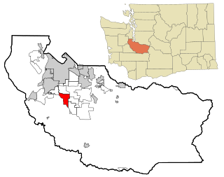
Midland is a census-designated place (CDP) in Pierce County, Washington. The population was 9,962 at the time of the 2020 census.

Puyallup is a city in Pierce County, Washington, United States. It is on the Puyallup River about 10 miles (16 km) southeast of Tacoma and 35 miles (56 km) south of Seattle. The city had a population of 42,973 at the 2020 census.

South Hill is a census-designated place (CDP) in Pierce County, Washington, immediately south of Puyallup. The population was 64,708 at time of the 2020 census, up from 52,431 in 2010. The area primarily consists of suburban housing and shopping with several retail shopping centers, residential neighborhoods, and apartment/condo complexes throughout. Because South Hill is unincorporated, its addresses are part of the Puyallup "postal city" or ZCTA.
Spanaway is a census-designated place (CDP) in Pierce County, Washington, United States. The population was 35,476 at the 2020 census, up from 27,227 in 2010. Spanaway is an unincorporated area near Tacoma, and is often identified together with the more urban, less wealthy Parkland.

Steilacoom is a town in Pierce County, Washington, United States. The population was 6,727 at the 2020 census. Steilacoom incorporated in 1854 and became the first incorporated town in what is now the state of Washington. It has also become a bedroom community for service members stationed at Joint Base Lewis–McChord, aka McChord AFB and Fort Lewis.
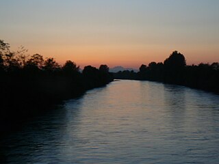
The Puyallup River is a river in the U.S. state of Washington. About 45 miles (72 km) long, it is formed by glaciers on the west side of Mount Rainier. It flows generally northwest, emptying into Commencement Bay, part of Puget Sound. The river and its tributaries drain an area of about 948 square miles (2,460 km2) in Pierce County and southern King County.
Browns Point is a census-designated place (CDP) in Pierce County, Washington, United States, bordered by Tacoma on the east and Puget Sound on all other sides. The population was 1,198 at the 2010 census. The Tacoma neighborhood immediately adjacent to Browns Point is also referred to locally as "Browns Point".

State Route 161 (SR 161) is a 36.25-mile-long (58.34 km) state highway serving Pierce and King counties in the U.S. state of Washington. The highway begins at SR 7 southwest of Eatonville and travels north as Meridian Avenue to Puyallup, becoming concurrent with SR 512 and SR 167. SR 161 continues northwest as the Enchanted Parkway to end at an intersection with SR 18 in Federal Way, west of Interstate 5 (I-5). The highway serves the communities of Graham and South Hill before reaching Puyallup and the communities of Edgewood, Milton, and Lakeland South before reaching Federal Way.

The Daffodil Festival is a regional festival and royalty leadership program. The Grand Floral Parade is held in Pierce County, Washington, every April. It consists of a flower parade and a year-long royalty program to select a festival queen from one of the 24 area high schools. Each year, the Royal Court spend thousands of hours promoting education, community pride and volunteerism in the county. In 2012, the Royal Court was named the "Official Ambassadors of Pierce County" by the County Executive and the Pierce County Council.

Alder Lake is a 7 mi (11 km) long reservoir on the Nisqually River in Eatonville, Washington in the U.S. state of Washington, which was created by the construction of Alder Dam by Tacoma Power in September 1944. At the very eastern end of the lake is the town of Elbe, Washington.
Ohop Valley is an agricultural region in Pierce County, Washington, United States. It is located between Electron and Eatonville, and contains the unincorporated settlement of Ohop. Ohop Creek, which runs through the valley, feeds into Ohop Lake and its waters eventually join the Puyallup River.

Lake Kapowsin is a lake in Pierce County, Washington, about halfway between Tacoma on Puget Sound, and Mount Rainier in the Cascade Mountains. The lake is 2.5 miles (4.0 km) long and 0.15–0.5 miles (0.24–0.80 km) wide, lying in a channel formed by meltwater from the Puget lobe of the Vashon glacier during the Pleistocene glaciation. A small island, Jaybird Island, lies in the northern half of the lake. As indicated by a drowned forest in the lake and other evidence, the Puyallup River was inundated about 550 years ago by a lahar from Mount Rainier called the Electron Mudflow. The mudflow partially filled the channel and blocked Ohop Creek's outlet, forming present-day Lake Kapowsin.
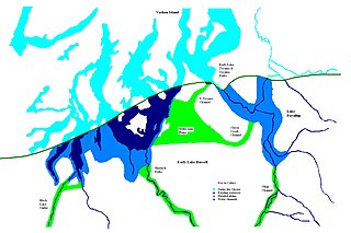
Lake Puyallup developed along the south edge of the Puget Sound Glacier. The glacier was in retreat northward after having reached its most southerly point. Drainage off the north face of Mount Rainier and the melting ice of the glacier was trapped in the valley of the Puyallup River. As the glacier moved north, the lake grew until it reached its largest capacity with the glacier at the glacial front across the Puyallup valley just south of Commencement Bay at Tacoma and northern bend of the White River at Auburn. When the ice retreated further north, it was reduced in depth and volume and takes on the name of Lake Tacoma.


