North Bay Outlet

Last updated
The outlet in the NE corner of this map, the North Bay Outlet, passes near the current site of North Bay Ontario. Chippewa and Stanley Low Levels (Larsen 1987).jpg
The outlet in the NE corner of this map, the North Bay Outlet, passes near the current site of North Bay Ontario.

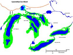
The North Bay Outlet was an outlet of a proglacial lake that preceded present day Lake Huron, where it discharged its waters near present-day North Bay, rather than a more southerly route, as the Laurentian glaciation receded. [1] [2] Water drained down this route from approximately 10000 to 4500 bpe.

Glacial rebound raised the land around the outlet, leading to increased water levels in the lake, and finally the lake water finding a lower outlet. [1]

Related Research Articles

<span class="mw-page-title-main">Lake Agassiz</span> Large lake in central North America at the end of the last glacial period

Lake Agassiz was a large proglacial lake that existed in central North America during late Pleistocene, fed by meltwater from the retreating Laurentide Ice Sheet at the end of the last glacial period. At its peak, the lake's area was larger than all of the modern Great Lakes combined.

<span class="mw-page-title-main">Lake Simcoe</span> Lake in Ontario, Canada

Lake Simcoe is a lake in southern Ontario, Canada, the fourth-largest lake wholly in the province, after Lake Nipigon, Lac Seul, and Lake Nipissing. At the time of the first European contact in the 17th century the lake was called Ouentironk by the native Wendat/Ouendat (Huron) people. It was also known as Lake Taronto until it was renamed by John Graves Simcoe, the first Lieutenant-Governor of Upper Canada, in memory of his father, Captain John Simcoe of the Royal Navy. In Anishinaabemowin, the ancestral language of the First Nations living around this lake, namely Anishinaabek of Rama and Georgina Island First Nations, Lake Simcoe is called Zhooniyaang-zaaga'igan, meaning "Silver Lake".

<span class="mw-page-title-main">Barron River (Ontario)</span> River in Ontario, Canada

The Barron River is a river in the Saint Lawrence River drainage basin in Nipissing District and Renfrew County, Ontario, Canada. It flows from Clemow Lake in northern Algonquin Provincial Park and joins the Petawawa River, whose southern branch it forms, in the municipality of Laurentian Hills, near the municipality of Petawawa.

<span class="mw-page-title-main">Lake Michigan–Huron</span> Combined lake system in North America

Lake Michigan–Huron is the body of water combining Lake Michigan and Lake Huron, which are joined through the 5-mile-wide (8.0 km), 295-foot-deep (90 m), open-water Straits of Mackinac. Huron and Michigan are hydrologically a single lake because the flow of water through the straits keeps their water levels in overall equilibrium. Although the flow is generally eastward, the water moves in either direction depending on local conditions. Combined, Lake Michigan–Huron is the largest freshwater lake by area in the world. Lake Superior is larger than either individually, so it is counted as the largest of the Great Lakes when Lake Michigan and Lake Huron are considered separately.

<span class="mw-page-title-main">Lake Algonquin</span> Former lake in North America

Lake Algonquin was a prehistoric proglacial lake that existed in east-central North America at the time of the last ice age. Parts of the former lake are now Lake Huron, Georgian Bay, Lake Superior, Lake Michigan, Lake Nipigon, and Lake Nipissing.

<span class="mw-page-title-main">Lake Duluth</span> Former lake in North America

Lake Duluth was a proglacial lake that formed in the Lake Superior drainage basin as the Laurentide Ice Sheet retreated. The oldest existing shorelines were formed after retreat from the Greatlakean advance, sometime around 11,000 years B.P. Lake Duluth formed at the western end of the Lake Superior basin. Lake Duluth overflowed south through outlets in Minnesota and Wisconsin at an elevation of around 331 m above sea level.

<span class="mw-page-title-main">Early Lake Erie</span> Former lake in North America

Early Lake Erie was a prehistoric proglacial lake that existed at the end of the last ice age approximately 13,000 years ago. The early Erie fed waters to Glacial Lake Iroquois.

<span class="mw-page-title-main">Lake Ojibway</span> Former lake in Ontario & Quebec

Lake Ojibway was a prehistoric lake in what is now northern Ontario and Quebec in Canada. Ojibway was the last of the great proglacial lakes of the last ice age. Comparable in size to Lake Agassiz, and north of the Great Lakes, it was at its greatest extent c. 8,500 years BP. The former lakebed forms the modern Clay Belt, an area of fertile land.

<span class="mw-page-title-main">Lake Chicago</span> Prehistoric lake from the Wisconsin Glacial Period

Lake Chicago was a prehistoric proglacial lake that is the ancestor of what is now known as Lake Michigan, one of North America's five Great Lakes. Formed about 13,000 years ago and fed by retreating glaciers, it drained south through the Chicago Outlet River.

<span class="mw-page-title-main">Lake Maumee</span> Former lake in North America

Lake Maumee was a proglacial lake and an ancestor of present-day Lake Erie. It formed about 17,500 calendar years, or 14,000 Radiocarbon Years Before Present (RCYBP) as the Huron-Erie Lobe of the Laurentide Ice Sheet retreated at the end of the Wisconsin glaciation. As water levels continued to rise the lake evolved into Lake Arkona and then Lake Whittlesey.

Glacial Lake Connecticut formed over what is now Long Island Sound and coastal Connecticut at the fore edge of the ice sheet of the Wisconsin glaciation, as the lobe of the Laurentide Ice Sheet began to retreat, some 18 to 20,000 years before present. It was dammed by the terminal moraine that now forms the spine of Long Island and Fishers Island. About 15,000 BP, the moraine dam that impounded Lake Connecticut failed; the outlet, known as The Race for its tidal rip currents, lies between the North Fork of Long Island and Fishers Island. For a time, much of the lake bed was exposed to wind-driven erosion: the cue is found in soundings that reveal regional unconformities in the sediment bed of Long Island Sound.

<span class="mw-page-title-main">Traverse Gap</span> River channel in Minnesota, US

The Traverse Gap is an ancient river channel occupied by Lake Traverse, Big Stone Lake and the valley connecting them at Browns Valley, Minnesota. It is located on the border of the U.S. states of Minnesota and South Dakota. Traverse Gap has an unusual distinction for a valley: it is crossed by a continental divide, and in some floods, water has flowed across that divide from one drainage basin to the other. Before the Anglo-American Convention of 1818 it marked the border between British territory in the north and U.S. – or earlier, French – territory in the south.

Glacial River Warren, also known as River Warren, was a prehistoric river that drained Lake Agassiz in central North America between about 13,500 and 10,650 BP calibrated years ago. A part of the uppermost portion of the former river channel was designated a National Natural Landmark in 1966.

<span class="mw-page-title-main">Proglacial lakes of Minnesota</span>

The proglacial lakes of Minnesota were lakes created in what is now the U.S. state of Minnesota in central North America in the waning years of the last glacial period. As the Laurentide Ice Sheet decayed at the end of the Wisconsin glaciation, lakes were created in depressions or behind moraines left by the glaciers. Evidence for these lakes is provided by low relief topography and glaciolacustrine sedimentary deposits. Not all contemporaneous, these glacial lakes drained after the retreat of the lobes of the ice sheets that blocked their outlets, or whose meltwaters fed them. There were a number of large lakes, one of which, Glacial Lake Agassiz, was the largest body of freshwater known to have existed on the North American continent; there were also dozens of smaller and more transitory lakes filled from glacial meltwater, which shrank or dried as the ice sheet retreated north.

<span class="mw-page-title-main">Nipissing First Nation</span> Indian reserve in Ontario, Canada

Nipissing First Nation is a long-standing community of Nishnaabeg peoples located along the shorelines of Lake Nipissing in northern Ontario. They are referred to by many names in European historical records, since the colonists often adopted names given to them by other nations.

<span class="mw-page-title-main">Nipissing Great Lakes</span> Prehistoric proglacial lake

Nipissing Great Lakes was a prehistoric proglacial lake. Parts of the former lake are now Lake Superior, Lake Huron, Georgian Bay and Lake Michigan. It formed about 7,500 years before present (YBP). The lake occupied the depression left by the Labradorian Glacier. This body of water drained eastward from Georgian Bay to the Ottawa valley. This was a period of isostatic rebound raising the outlet over time, until it opened the outlet through the St. Clair valley, at one stage it had two stable outlets both draining to the east.

<span class="mw-page-title-main">Lake Chippewa</span> Former lake in North America

Lake Chippewa was a prehistoric proglacial lake. The basin is now Lake Michigan. It formed about 10,600 years before present (YBP). The lake occupied the depression left by the Michigan Lobe of the Laurentide Ice Sheet.

<span class="mw-page-title-main">Lake Whittlesey</span>

Lake Whittlesey was a proglacial lake that was an ancestor of present-day Lake Erie. It formed about 14,000 years ago. As the Erie Lobe of the Wisconsin Glacier retreated at the end of the last ice age, it left melt-water in a previously-existing depression area that was the valley of an eastward-flowing river known as the Erigan River that probably emptied into the Atlantic Ocean following the route of today's Saint Lawrence River. The lake stood at 735 feet (224 m) to 740 feet (230 m) above sea level. The remanent beach is not horizontal as there is a ‘hinge line’ southwest of a line from Ashtabula, Ohio, through the middle part of Lake St. Clair. The hinge line is where the horizontal beaches of the lake have been warped upwards towards the north by the isostatic rebound as the weight of the ice sheet was removed from the land. The rise is 60 feet (18 m) north into Michigan and the Ubly outlet. The current altitude of the outlet is 800 feet (240 m) above sea level. Where the outlet entered the Second Lake Saginaw at Cass City the elevation is 740 feet (230 m) above sea level. The Lake Whittlesey beach called the Belmore Beach and is a gravel ridge 10 feet (3.0 m) to 15 feet (4.6 m) high and one-eighth mile wide. Lake Whittlesey was maintained at the level of the Ubly outlet only until the ice melted back on the "Thumb" far enough to open a lower outlet. This ice recession went far enough to allow the lake to drop about 20 feet (6.1 m) below the lowest of the Arkona beaches to Lake Warren levels.

<span class="mw-page-title-main">Lake Stanley</span> Former lake in North America

Lake Stanley, also called the Stanley unconformity, is a postglacial freshwater lake that occupied part of what is now the basin of Lake Huron during a hydrologically significant period from 10,000 years Before Present (B.P.). The lake’s surface level was approximately 70 meters below the current lake’s water surface.

References

  1. 1 2 "THE NIPISSING GREAT LAKES". Michigan State University . Retrieved 2019-11-23. These lakes started forming as the North Bay outlet opened up, effectively draining Glacial Lake Algonquin down to the Chippewa-Stanley level. With time, from 10,000 BP to about 4500 BP, the outlet rose, due to isostatic rebound.
  2. Paul F. Karrow (2005-07-25). "Algonquin-Nipissing Shorelines, North Bay, Ontario". Géographie Physique et Quaternaire. 58 (2–3): 297–304. doi:10.7202/013144ar . Retrieved 2019-11-23. Terasmae and Hughes (1960) used palynology, radiocarbon dates from isolation basin basal organic sediments, and varves to conclude the North Bay outlet was deglaciated between 11 000 and 10 000 BP.