
Hudson Bay, sometimes called Hudson's Bay, is a large body of saltwater in northeastern Canada with a surface area of 1,230,000 km2 (470,000 sq mi). It is located north of Ontario, west of Quebec, northeast of Manitoba, and southeast of Nunavut, but politically entirely part of Nunavut. It is an inland marginal sea of the Arctic Ocean. The Hudson Strait provides a connection between the Labrador Sea and the Atlantic Ocean in the northeast, while the Foxe Channel connects Hudson Bay with the Arctic Ocean in the north. The Hudson Bay drainage basin drains a very large area, about 3,861,400 km2 (1,490,900 sq mi), that includes parts of southeastern Nunavut, Alberta, Saskatchewan, Ontario, Quebec, all of Manitoba, and parts of the U.S. states of North Dakota, South Dakota, Minnesota, and Montana. Hudson Bay's southern arm is called James Bay.
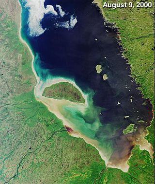
James Bay is a large body of water located on the southern end of Hudson Bay in Canada. It borders the provinces of Quebec and Ontario, and is politically part of Nunavut. Its largest island is Akimiski Island.
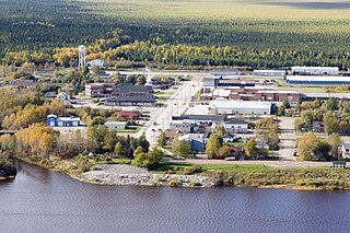
Moosonee is a town in northern Ontario, Canada, on the Moose River approximately 19 km (12 mi) south of James Bay. It is considered to be "the Gateway to the Arctic" and has Ontario's only saltwater port. Nearby on Moose Factory Island is the community of Moose Factory to which it is connected by water taxi in the summer and ice road in the winter.
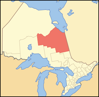
Cochrane District is a district and census division in Northeastern Ontario in the Canadian province of Ontario. It was created in 1921 from parts of Timiskaming and Thunder Bay districts.

The Moose River is a river in the Hudson Plains ecozone of northern Ontario, Canada. The river flows 100 km northeast from the confluence of the Mattagami and Missinaibi Rivers into James Bay. Its drainage basin is 108,500 square kilometres (41,900 sq mi) and it has a mean discharge rate of 1,370 cubic metres (48,000 cu ft). Its full length is 547 kilometres (340 mi) if counted from the head of the Mattagami River.
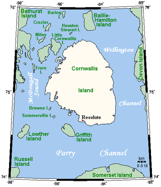
Cornwallis Island is one of the Queen Elizabeth Islands, part of the Arctic Archipelago, in the Qikiqtaaluk Region of Nunavut in the Canadian Arctic. It lies to the west of Devon Island, the largest uninhabited island in the world, and at its greatest length is about 113 km (70 mi). At 6,995 km2 (2,701 sq mi) in size, it is the 96th largest island in the world, and Canada's 21st largest island. Cornwallis Island is separated by the Wellington Channel from Devon Island, and by the Parry Channel from Somerset Island to the south. Northwest of Cornwallis Island lies Little Cornwallis Island, the biggest of a group of small islands at the north end of McDougall Sound, which separates Cornwallis Island from nearby Bathurst Island.

Hay River, known as "the Hub of the North", is a town in the Northwest Territories, Canada, located on the south shore of Great Slave Lake, at the mouth of the Hay River. The town is separated into two sections, a new town and an old town with the Hay River/Merlyn Carter Airport between them. The town is in the South Slave Region, and along with Fort Smith, the town is home to one of the two regional offices.
Moose Factory is a community in the Cochrane District, Ontario, Canada. It is located on Moose Factory Island, near the mouth of the Moose River, which is at the southern end of James Bay. It was the first English-speaking settlement in lands now making up Ontario and the second Hudson's Bay Company post to be set up in North America after Fort Rupert. On the mainland, across the Moose River, is the nearby community of Moosonee, which is accessible by water taxi in the summer, ice road in the winter, and chartered helicopter in the off-season.

Fort Albany First Nation is a Cree First Nation in Cochrane District in Northeastern Ontario, Canada, within the territory covered by Treaty 9. Situated on the southern shore of the Albany River on the west coast of James Bay, Fort Albany First Nation is accessible only by air, water, or by winter road.

Gore Bay became a town on 7 April 1890, on Manitoulin Island in Ontario, Canada. Located on Gore Bay, a bay of Lake Huron's North Channel, it is one of the two incorporated towns of Manitoulin District, of which it is the administrative and government seat. After the Treaty of 1862, Manitoulin Island was open for white settlement. Small towns began to emerge from the wilderness, and hotels were developed to provide lodgings for prospective land purchasers. This led to the formation of the town Gore Bay. The town's name is believed to be referencing the gore-shaped harbour. Other theories for the namesake are probably for Francis Gore (1769–1852), Lieutenant-Governor of Upper Canada from 1806 to 1817, or after the steamer Gore, which ran between Sault Ste. Marie and Collingwood from 1860 to 1870.
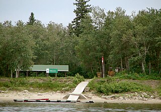
Tidewater Provincial Park is a provincial park located on five islands in the Moose River estuary between Moosonee and Moose Factory, Ontario, Canada:
Peawanuck is an isolated Cree community in the Kenora District, Ontario, Canada. It is located near the confluence of the Winisk and Shamattawa rivers, about 35 km from the Winisk River's end in Hudson Bay. Its population is 237.
The Canadian territory of Nunavut covers about 1.9 million square kilometres of land and water including part of the mainland, most of the Arctic islands, and all of the islands in Hudson Bay, James Bay, and Ungava Bay which belonged to the Northwest Territories. This makes it the fifth largest country subdivision in the world. If Nunavut were a country, it would rank 13th in area, after the Democratic Republic of the Congo. Nunavut has land borders with Manitoba, the Northwest Territories on several islands as well as the mainland, and a tiny land border with Newfoundland and Labrador on Killiniq Island. Additionally, Nunavut has a land border with Greenland on Hans Island.
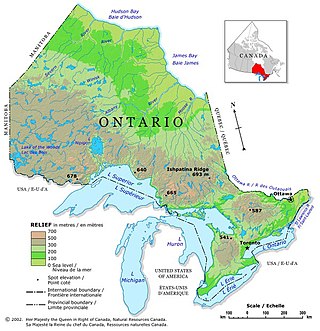
Ontario is located in East/Central Canada. It is Canada's second largest province by land area. Its physical features vary greatly from the Mixedwood Plains in the southeast to the boreal forests and tundra in the north. Ontario borders Manitoba to the west, Hudson Bay and James Bay to the north, Quebec to the east, and the Great Lakes and the United States to the south. The province is named for Great Lake Ontario, an adaptation of the Iroquois word Onitariio, meaning "beautiful lake", or Kanadario, variously translated as "beautiful water". There are approximately 250,000 lakes and over 100,000 kilometres (62,000 mi) of rivers in the province.
Moose Cree is a dialect of the Cree language spoken mainly in Moose Factory, Ontario.
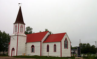
St. Thomas' Anglican Church is an historic Carpenter Gothic style Anglican church edifice built by the Hudson's Bay Company in Moose Factory, Ontario, Canada.

Moosonee station is a railway station in Moosonee, Ontario, Canada operated by the Ontario Northland Railway. It is the northern terminus of Ontario Northland's Polar Bear Express, located about 12 miles south of the shore of James Bay on the north bank of the Moose River. It consists of a single storey station building, sheds, and a small train yard.

This is the outline of the geography of the city of Ottawa, the capital of Canada. Ottawa's current borders were formed in 2001, when the former city of Ottawa amalgamated with the ten other municipalities within the former Regional Municipality of Ottawa–Carleton. Ottawa is now a single-tiered census division, home to 1,017,449 people.

Factory Island 1 is a Cree First Nations reserve on Moose Factory Island in northern Ontario. It is one of two reserves for the Moose Cree First Nation.

The Southern Hudson Bay taiga is a terrestrial ecoregion, as classified by the World Wildlife Fund, which extends along the southern coast of Hudson Bay and resides within the larger taiga biome. The region is nearly coterminous with the Hudson Plain, a Level I ecoregion of North America as designated by the Commission for Environmental Cooperation (CEC) in its North American Environmental Atlas.

