Factory Island 1

Last updated

Factory Island 1
Factory Island Indian Reserve No. 1
Factory Island IR.JPG
Canada Ontario location map 2.svg
Red pog.svg
Factory Island 1
Coordinates: 51°16′09″N80°35′35″W / 51.26917°N 80.59306°W / 51.26917; -80.59306 [1]
CountryCanada
Province Ontario
District Cochrane
First Nation Moose Cree
Area
[3]
  Land3.08 km2 (1.19 sq mi)
Population
 (2011) [3]
  Total1,414
  Density459.3/km2 (1,190/sq mi)
Website www.moosecree.com

Factory Island 1 is a Cree First Nations reserve on Moose Factory Island in northern Ontario. It is one of two reserves for the Moose Cree First Nation.

Contents

Land use

The northern two-thirds of the island comprises this reserve or land north of Museum Street. Most residential, the reserve is home to a Northern Store, Cree Interpretative Centre and Treeline Diner. Key government services, including the hospital, are located in the southern part of the island under the Unorganized North Cochrane District.

Half of the reserve, namely the north end is tree covered land.
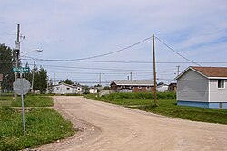
Transportation

Gravel roads are used for vehicles within town. There are no bridges, but an ice road is available during the winter season.

Climate

The reserve and the Moosonee area has a very cold humid continental climate (Köppen Dfb). The climate data is from Moosonee, around 3 km (1.9 mi) to the west.

Climate data for Moosonee (Moosonee Upper Air (UA))
WMO ID: 71836; coordinates 51°16′N80°39′W / 51.267°N 80.650°W / 51.267; -80.650 (Moosonee Upper Air)) ; elevation: 10.0 m (32.8 ft); 1981–2010 normals, extremes 1877–present [lower-alpha 1]
MonthJanFebMarAprMayJunJulAugSepOctNovDecYear
Record high humidex 7.28.926.629.636.839.344.743.440.828.820.712.944.7
Record high °C (°F)7.2
(45.0)
10.6
(51.1)
25.0
(77.0)
29.0
(84.2)
34.0
(93.2)
37.5
(99.5)
37.8
(100.0)
35.0
(95.0)
32.2
(90.0)
29.0
(84.2)
20.5
(68.9)
13.2
(55.8)
37.8
(100.0)
Average high °C (°F)−13.6
(7.5)
−10.5
(13.1)
−3.9
(25.0)
4.3
(39.7)
13.3
(55.9)
19.1
(66.4)
22.6
(72.7)
21.1
(70.0)
15.7
(60.3)
7.9
(46.2)
−0.5
(31.1)
−9.3
(15.3)
5.5
(41.9)
Daily mean °C (°F)−20.0
(−4.0)
−17.5
(0.5)
−11.1
(12.0)
−1.8
(28.8)
6.8
(44.2)
12.2
(54.0)
15.8
(60.4)
14.9
(58.8)
10.5
(50.9)
3.8
(38.8)
−4.3
(24.3)
−14.5
(5.9)
−0.5
(31.1)
Average low °C (°F)−26.3
(−15.3)
−24.6
(−12.3)
−18.3
(−0.9)
−7.9
(17.8)
0.2
(32.4)
5.3
(41.5)
8.9
(48.0)
8.6
(47.5)
5.2
(41.4)
−0.5
(31.1)
−8.2
(17.2)
−19.7
(−3.5)
−6.4
(20.5)
Record low °C (°F)−48.9
(−56.0)
−47.8
(−54.0)
−44.4
(−47.9)
−33.9
(−29.0)
−17.8
(0.0)
−7.0
(19.4)
−2.2
(28.0)
−3.1
(26.4)
−6.1
(21.0)
−16.7
(1.9)
−34.4
(−29.9)
−44.4
(−47.9)
−48.9
(−56.0)
Record low wind chill −56−53−49−37−26−10−4−5−10−20−40−51−56
Average precipitation mm (inches)33.0
(1.30)
28.6
(1.13)
35.3
(1.39)
38.1
(1.50)
54.6
(2.15)
71.7
(2.82)
96.8
(3.81)
77.8
(3.06)
95.3
(3.75)
74.7
(2.94)
56.3
(2.22)
41.5
(1.63)
703.6
(27.70)
Average rainfall mm (inches)0.1
(0.00)
1.8
(0.07)
6.5
(0.26)
21.0
(0.83)
47.7
(1.88)
71.5
(2.81)
96.8
(3.81)
77.8
(3.06)
94.6
(3.72)
62.1
(2.44)
19.1
(0.75)
3.5
(0.14)
502.6
(19.79)
Average snowfall cm (inches)39.9
(15.7)
31.7
(12.5)
31.0
(12.2)
17.9
(7.0)
6.6
(2.6)
0.2
(0.1)
0.0
(0.0)
0.0
(0.0)
0.6
(0.2)
13.2
(5.2)
40.6
(16.0)
45.2
(17.8)
226.8
(89.3)
Average precipitation days (≥ 0.2 mm)14.811.310.910.212.513.916.415.218.516.515.715.9171.7
Average rainy days (≥ 0.2 mm)0.230.952.25.110.813.816.415.218.513.44.81.1102.3
Average snowy days (≥ 0.2 cm)15.011.010.16.73.10.170.00.00.095.013.115.679.7
Mean monthly sunshine hours 93.6128.7161.6192.0221.2213.5249.2219.7134.888.552.955.21,810.7
Percent possible sunshine 35.845.744.046.345.943.150.048.635.426.619.722.338.6
Source: Environment and Climate Change Canada [4] [5] [6] [7] [8]

Footnotes

  1. Long term climate data for the Moosonee area was recorded in Moose Factory from October 1877 to December 1938, and in Moosonee from October 1932 to present.

Related Research Articles

<span class="mw-page-title-main">Cree</span> Group of First Nations peoples in North America

The Cree are a North American Indigenous people. They live primarily in Canada, where they form one of the country's largest First Nations.

<span class="mw-page-title-main">Hudson Bay</span> Large body of saltwater in northeastern Canada

Hudson Bay, sometimes called Hudson's Bay, is a large body of saltwater in northeastern Canada with a surface area of 1,230,000 km2 (470,000 sq mi). It is located north of Ontario, west of Quebec, northeast of Manitoba and southeast of Nunavut, but politically entirely part of Nunavut. It is an inland marginal sea of both the Arctic and Atlantic Oceans. It drains a very large area, about 3,861,400 km2 (1,490,900 sq mi), that includes parts of southeastern Nunavut, Alberta, Saskatchewan, Ontario, Quebec, all of Manitoba, and parts of the U.S. states of North Dakota, South Dakota, Minnesota, and Montana. Hudson Bay's southern arm is called James Bay.

<span class="mw-page-title-main">James Bay</span> Bay on the southern end of the Hudson Bay, Canada

James Bay is a large body of water located on the southern end of Hudson Bay in Canada. It borders the provinces of Quebec and Ontario, and is politically part of Nunavut. Its largest island is Akimiski Island.

<span class="mw-page-title-main">The Pas</span> Town in Manitoba, Canada

The Pas is a town in Manitoba, Canada, at the confluence of the Pasquia River and the Saskatchewan River and surrounded by the unorganized Northern Region of the province. It is approximately 520 km (320 mi) northwest of the provincial capital, Winnipeg, and 35 km (22 mi) from the border of Saskatchewan. It is sometimes still called Paskoyac by locals after the first trading post, called Fort Paskoya and constructed during French colonial rule. The Pasquia River begins in the Pasquia Hills in east central Saskatchewan. The French in 1795 knew the river as Basquiau.

<span class="mw-page-title-main">Moosonee</span> Town in Ontario, Canada

Moosonee is a town in northern Ontario, Canada, on the Moose River approximately 19 km (12 mi) south of James Bay. It is considered to be "the Gateway to the Arctic" and has Ontario's only saltwater port. Nearby on Moose Factory Island is the community of Moose Factory to which it is connected by water taxi in the summer and ice road in the winter.

<span class="mw-page-title-main">Fort Chipewyan</span> Hamlet in Alberta, Canada

Fort Chipewyan, commonly referred to as Fort Chip, is a hamlet in northern Alberta, Canada, within the Regional Municipality (RM) of Wood Buffalo. It is located on the western tip of Lake Athabasca, adjacent to Wood Buffalo National Park, approximately 223 kilometres (139 mi) north of Fort McMurray.

Enterprise is a hamlet in the South Slave Region of the Northwest Territories, Canada, located between Great Slave Lake and the Alberta border on the Hay River.

<span class="mw-page-title-main">Cochrane District</span> District in Ontario, Canada

Cochrane District is a district and census division in Northeastern Ontario in the Canadian province of Ontario. It was created in 1921 from parts of Timiskaming and Thunder Bay districts.

<span class="mw-page-title-main">Hay River, Northwest Territories</span> Town in Northwest Territories, Canada

Hay River, known as "the Hub of the North," is a town in the Northwest Territories, Canada, located on the south shore of Great Slave Lake, at the mouth of the Hay River. The town is separated into two sections, a new town and an old town with the Hay River/Merlyn Carter Airport between them. The town is in the South Slave Region, and along with Fort Smith, the town is home to one of the two regional offices.

<span class="mw-page-title-main">Fort Simpson</span> Village in Northwest Territories, Canada

Fort Simpson is a village, the only one in the entire territory, in the Dehcho Region of the Northwest Territories, Canada. The community is located on an island at the confluence of the Mackenzie and Liard rivers. It is approximately 500 km (310 mi) west of Yellowknife. Both rivers were traditionally trade routes for the Hudson's Bay Company and the native Dene people of the area.

<span class="mw-page-title-main">Moose Factory</span> Place in Ontario, Canada

Moose Factory is a community in the Cochrane District, Ontario, Canada. It is located on Moose Factory Island, near the mouth of the Moose River, which is at the southern end of James Bay. It was the first English-speaking settlement in lands now making up Ontario and the second Hudson's Bay Company post to be set up in North America after Fort Rupert. On the mainland, across the Moose River, is the nearby community of Moosonee, which is accessible by water taxi in the summer, ice road in the winter, and chartered helicopter in the off-season.

<span class="mw-page-title-main">Fort Albany First Nation</span> Canadian settlement

Fort Albany First Nation is a Cree First Nation in Cochrane District in Northeastern Ontario, Canada, within the territory covered by Treaty 9. Situated on the southern shore of the Albany River, Fort Albany First Nation is accessible only by air, water, or by winter road.

<span class="mw-page-title-main">Chapleau, Ontario</span> Township in Ontario, Canada

Chapleau is a township in Sudbury District, Ontario, Canada. It is home to one of the world's largest wildlife preserves. Chapleau has a population of 1,942 according to the 2016 Canadian census.

<span class="mw-page-title-main">Attawapiskat First Nation</span> First Nation in Kenora District, Ontario, Canada

The Attawapiskat First Nation is an isolated First Nation located in Kenora District in northern Ontario, Canada, at the mouth of the Attawapiskat River on James Bay. The traditional territory of the Attawapiskat First Nation extends beyond their reserve up the coast to Hudson Bay and hundreds of kilometres inland along river tributaries. The community is connected to other towns along the shore of James Bay by the seasonal ice road/winter road constructed each December, linking it to the towns of Kashechewan First Nation, Fort Albany, and Moosonee Attawapiskat, Fort Albany, and Kashechewan operate and manage the James Bay Winter Road through the jointly owned Kimesskanemenow Corporation, named after the Cree word for "our road" -kimesskanemenow. Attawapiskat is the most remote northerly link on the 310 km (190 mi) road to Moosonee. They control the reserves at Attawapiskat 91 and Attawapiskat 91A.

<span class="mw-page-title-main">Whapmagoostui</span> Cree community in Quebec, Canada

Whapmagoostui is the northernmost Cree village in Quebec, Canada, located at the mouth of the Great Whale River on the coast of Hudson Bay in Nunavik. About 906 Cree with about 650 Inuit, living in the neighbouring village of Kuujjuarapik. The community is accessible only by air and, in late summer, by boat. Whapmagoostui is about 250 km (160 mi) north of the nearest Cree village, Chisasibi.

<span class="mw-page-title-main">Norway House</span> Population centre in Manitoba, Canada

Norway House is a population centre of over 5,000 people, some 30 km (19 mi) north of Lake Winnipeg, on the bank of the eastern channel of Nelson River, in the province of Manitoba, Canada. The population centre shares the name Norway House with the northern community of Norway House and Norway House 17, a First Nation reserve of the Norway House Cree Nation. Thus, Norway House has both a Chief and a Mayor.

<span class="mw-page-title-main">Cross Lake, Manitoba</span> Place in Manitoba, Canada

Cross Lake is a community in the Northern Region of the Canadian province of Manitoba, situated on the shores of the Nelson River where the river enters the namesake Cross Lake. An all-weather road, PR 374, connects the communities to PR 373 via the Kichi Sipi Bridge.

Hay River Reserve is one of only three Indian reserves in Canada's Northwest Territories. Located in the South Slave Region, it is a Slavey community with a population of 259, of which the majority are First Nations and some Métis, at the 2021 Canadian census, a 16.2% decrease from the 2016 census. The main languages on the reserve are South Slavey, and English. In 2017 the Government of the Northwest Territories reported that the population was 329, resulting in an average annual growth rate of 0.4% between 2007 and 2017.

<span class="mw-page-title-main">Moose Cree First Nation</span>

The Moose Cree First Nation is a Cree First Nation band government in northern Ontario, Canada. Their traditional territory is on the west side of James Bay. The nation has two reserves: Factory Island 1 ; and Moose Factory 68, a tract of land about 15 km upstream on the Moose River covering 168.82 square kilometres (65.18 sq mi).

<span class="mw-page-title-main">Moose Factory Island</span>

Moose Factory Island is an island in the Moose River, Ontario, Canada, about 16 km (9.9 mi) from its mouth at James Bay. It is adjacent to the community of Moosonee across the Moose River, from which it is accessible by water taxi. The island is home to the community of Moose Factory. This town is associated with the entire island, but politically, the island is divided into two entities:

References

  1. "Factory Island 1". Geographical Names Data Base . Natural Resources Canada.
  2. "Factory Island 1". Geographical Names Data Base . Natural Resources Canada.
  3. 1 2 "Factory Island 1 census profile". 2011 Census of Population . Statistics Canada. 8 February 2012. Retrieved 27 May 2015.
  4. "Moosonee UA". Canadian Climate Normals 1981–2010. Environment and Climate Change Canada. 14 July 2023. Retrieved 15 September 2023.
  5. "Moose Factory". Canadian Climate Data. Environment and Climate Change Canada. 14 July 2023. Retrieved 15 September 2023.
  6. "Daily Data Report for October 2011". Canadian Climate Data. Environment and Climate Change Canada. 14 July 2023. Retrieved 15 September 2023.
  7. "Daily Data Report for March 2012". Canadian Climate Data. Environment and Climate Change Canada. 14 July 2023. Retrieved 15 September 2023.
  8. "Daily Data Report for November 2016". Canadian Climate Data. Environment and Climate Change Canada. 14 July 2023. Retrieved 15 September 2023.