Unorganized South East Cochrane District

Last updated
Unorganized South East Cochrane District
Cochrane, Unorganized, South East Part
Bourkes ON.JPG
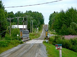
Ontario Northland Railway crossing in Bourkes
Canada Ontario location map 2.svg
Red pog.svg
Unorganized South East Cochrane
Coordinates: 48°18.5′N80°14′W / 48.3083°N 80.233°W / 48.3083; -80.233
CountryFlag of Canada (Pantone).svg  Canada
ProvinceFlag of Ontario.svg  Ontario
District Cochrane
Government
  Federal riding Timmins-James Bay
  Prov. riding Timmins—James Bay
Area
[1]
  Land53.19 km2 (20.54 sq mi)
Population
 (2011) [1]
  Total15
  Density0.3/km2 (0.8/sq mi)
Time zone UTC-5 (EST)
  Summer (DST) UTC-4 (EDT)
Area code 705

Unorganized South East Cochrane District is an unorganized area in the Canadian province of Ontario, encompassing the small portion of the Cochrane District, immediately surrounding Highway 11 at the division's southern boundary with the Timiskaming District, which is not part of the municipality of Black River-Matheson which surrounds it. [2] It consists of the southern half of the geographic township of Benoit and is the southernmost limit of the Great Clay Belt of northern Ontario.

Contents

The division had a population of 15 in the Canada 2011 Census, and a land area of 53.19 square kilometres. [3] The main settlement in the division is the ghost town of Bourkes, located at the Ontario Northland Railway crossing on Bourkes road. The area was initially settled by Scandinavian immigrants around 1911 as a dairy farming region and by 1914 had a store, railway station and siding, school, post office and bunkhouse as well as two gold mines. [4] The population peaked in the 1930s at 300, but slowly declined after the two local gold mines were shuttered and the timber trade dried up. The post office was closed in 1969 and the last store closed in the 1970s, today, only the disused bunkhouse and a few scattered houses remain of the settlement.

Demographics

Canada census – Cochrane, Unorganized, South East Part community profile
2011
Population15 (-40.0% from 2006)
Land area53.19 km2 (20.54 sq mi)
Population density0.3/km2 (0.78/sq mi)
Median age
Private dwellings13 (total) 
Median household income
References: 2011 [5] earlier [6] [7]

Population: [8]

See also

Related Research Articles

<span class="mw-page-title-main">Timiskaming District</span> District in Ontario, Canada

Timiskaming is a district and census division in Northeastern Ontario in the Canadian province of Ontario. The district was created in 1912 from parts of Algoma, Nipissing, and Sudbury districts. In 1921, Cochrane District was created from parts of this district and parts of Thunder Bay District.

<span class="mw-page-title-main">Unorganized North Cochrane District</span> Unorganized area in Ontario, Canada

Unorganized North Cochrane District is an unorganized area in the District of Cochrane in Northeastern Ontario, Canada. It comprises all parts of the district north of Timmins and Iroquois Falls which are not part of an incorporated municipality.

<span class="mw-page-title-main">Cochrane, Ontario</span> Town in Ontario, Canada

Cochrane is a town in northeastern Ontario, Canada. It is located east of Kapuskasing, northeast of Timmins, south of Moosonee, and north of Iroquois Falls. It is about a one-hour drive from Timmins, the major city of the region. It is the seat of Cochrane District. The town's population is made up of about half anglophone and half francophone residents.

<span class="mw-page-title-main">Sudbury District</span> District in Ontario, Canada

The Sudbury District is a district in Northeastern Ontario in the Canadian province of Ontario. It was created in 1894 from townships of eastern Algoma District and west Nipissing District.

<span class="mw-page-title-main">Cochrane District</span> District in Ontario, Canada

Cochrane District is a district and census division in Northeastern Ontario in the Canadian province of Ontario. It was created in 1921 from parts of Timiskaming and Thunder Bay districts.

<span class="mw-page-title-main">Unorganized Centre Parry Sound District</span> Unorganized area in Ontario, Canada

Unorganized Centre Parry Sound District is an unorganized area in central Ontario, Canada, between Georgian Bay and Lake Nipissing in the District of Parry Sound. It is made up of geographic townships which have no governing bodies and which are not incorporated as municipalities. The territory consists of two non-contiguous areas, with the main part located directly south of the French River and Lake Nipissing, and east of Georgian Bay. Shawanaga Township is a small exclave south of it along Highway 69.

<span class="mw-page-title-main">Nipissing District</span> District in Ontario, Canada

Nipissing District is a district in Northeastern Ontario in the Canadian province of Ontario. It was created in 1858. The district seat is North Bay.

<span class="mw-page-title-main">Thunder Bay District</span> District in Ontario, Canada

Thunder Bay District is a district and census division in Northwestern Ontario in the Canadian province of Ontario. The district seat is Thunder Bay.

<span class="mw-page-title-main">Unorganized Kenora District</span> Unorganized area in Ontario, Canada

Unorganized Kenora District is an unorganized area in northwestern Ontario, Canada, in Kenora District. Constituting 98.39 percent of the district's land area, yet only 10.93 percent of its population, it is essentially the remainder of the district's territory after all incorporated cities, municipalities, townships, Indian reserves, and Indian settlements have been excluded. It is by far the largest municipal-equivalent level census division in Ontario, covering over 35 percent of the entire provincial land area, yet only about 0.05 percent of the population of Ontario.

<span class="mw-page-title-main">Unorganized Thunder Bay District</span> Unorganized area in Ontario, Canada

Unorganized Thunder Bay District is an unorganized area in northwestern Ontario, Canada in Thunder Bay District. It comprises all parts of the district that are not part of an incorporated municipality or a First Nations reserve.

<span class="mw-page-title-main">Unorganized North Algoma District</span> Unorganized area in Ontario, Canada

Unorganized North Algoma District is an unorganized area in northeastern Ontario, Canada, comprising all areas in Algoma District, north of the Sault Ste. Marie to Elliot Lake corridor, which are not part of an incorporated municipality or a First Nation. It covers 44,077.03 km2 (17,018.24 sq mi) of land, and had a population of 6050 in 2021. Many of these communities were/are stations on the Algoma Central Railway or were logging/mining towns.

<span class="mw-page-title-main">Temagami</span> Municipality in Ontario, Canada

Temagami, formerly spelled Timagami, is a municipality in northeastern Ontario, Canada, in the Nipissing District with Lake Temagami at its heart.

<span class="mw-page-title-main">Unorganized North Sudbury District</span> Unorganized area in Ontario, Canada

Unorganized North Sudbury District is an unorganized area in the Canadian province of Ontario, comprising all portions of the Sudbury District which are not organized into incorporated municipalities. Despite its name, there is no longer an accompanying "South Part", as that subdivision has subsequently been incorporated into municipalities and Statistics Canada has not renamed the North Part.

<span class="mw-page-title-main">Sioux Narrows-Nestor Falls</span> Township in Ontario, Canada

Sioux Narrows-Nestor Falls is a township in the Canadian province of Ontario, located in the Kenora District. It is located on the eastern shores of Lake of the Woods along Ontario Highway 71.

<span class="mw-page-title-main">Lake of the Woods, Ontario</span> Township in Ontario, Canada

Lake of the Woods is a township in the Canadian province of Ontario, located within the Rainy River District. The township is located on the eponymous Lake of the Woods, consisting of mainland in the south-east part of the lake, the southern shores of Aulneau Peninsula, along with several islands in the lake, including Big Island and Bigsby Island. It fully surrounds the Anishnaabeg of Naongashiing, Big Grassy River 35G, Big Island Mainland 93, and Saug-a-Gaw-Sing 1 First Nation reserves.

<span class="mw-page-title-main">Unorganized Rainy River District</span> Unorganized area in Ontario, Canada

Unorganized Rainy River District is an unorganized area in the Rainy River District of Ontario, Canada, comprising all communities in the district which are not part of incorporated municipalities. Quetico Provincial Park is located entirely within this area.

<span class="mw-page-title-main">Unorganized East Timiskaming District</span> Unorganized area in Ontario, Canada

Unorganized East Timiskaming District is an unorganized area in the Canadian province of Ontario, comprising the unincorporated portions of the Timiskaming District lying east of the municipal boundaries of Kirkland Lake and north of the municipal boundaries of Gauthier, Larder Lake and McGarry.

Unorganized South East Algoma District is an unorganized area in the Canadian province of Ontario, comprising a small unincorporated portion in the southeasternmost corner of the Algoma District. It comprises a small strip of land which lies between the territory of the Sagamok First Nation and the Algoma District's boundary with the Sudbury District, as well as several small islands within the North Channel of Lake Huron, such as Eagle, Fréchette, Fox, Hotham, Middleton, North and South Benjamin Islands.

Unorganized Mainland Manitoulin was an unorganized area in the Canadian province of Ontario, encompassing the small mainland portion of the Manitoulin District which was not part of the municipality of Killarney. It was dissolved and annexed into Killarney in 2006.

Unorganized South West Cochrane District is an unorganized area in the Canadian province of Ontario, encompassing the small portion of the Cochrane District, between Black River-Matheson and Timmins, which is not part of either municipality.

References

  1. 1 2 "Cochrane, Unorganized, South East Part census profile". 2011 Census of Population . Statistics Canada. Retrieved 2012-02-10.
  2. GeoSearch 2006
  3. "Cochrane, Unorganized, South East Part census profile". 2011 Census of Population . Statistics Canada. Retrieved 2012-02-10.
  4. "Bourkes - Ghost Town".
  5. "2011 Community Profiles". 2011 Canadian Census . Statistics Canada. March 21, 2019. Retrieved 2012-02-10.
  6. "2006 Community Profiles". 2006 Canadian Census . Statistics Canada. August 20, 2019.
  7. "2001 Community Profiles". 2001 Canadian Census . Statistics Canada. July 18, 2021.
  8. Statistics Canada: 1996, 2001, 2006 census