
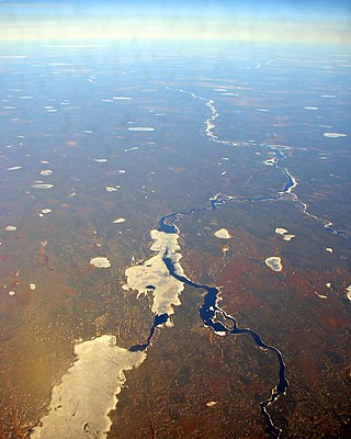
The English River is a river in Kenora District and Thunder Bay District in Northwestern Ontario, Canada. It flows through Lac Seul to join the Winnipeg River at Tetu Lake as a right tributary. The river is in the Hudson Bay drainage basin, is 615 kilometres (382 mi) long and has a drainage basin of 52,300 square kilometres (20,200 sq mi). Although there are several hydroelectric plants on this river, the English River upstream of Minnitaki Lake is notable as one of the few large river systems in northwestern Ontario with a natural flow and without any upstream source of pollution. It is the fourth longest river entirely in Ontario.

The Kenogami River is a river in the James Bay drainage basin in Thunder Bay and Cochrane districts in Northern Ontario, Canada, which flows north from Long Lake near Longlac to empty into the Albany River. The river is 320 kilometres (199 mi) in length and its name means "long water" in the Cree language. A portion of the river's headwaters have been diverted into the Lake Superior drainage basin.
The Albany River is a river in Northern Ontario, Canada, which flows northeast from Lake St. Joseph in Northwestern Ontario and empties into James Bay. It is 982 kilometres (610 mi) long to the head of the Cat River, tying it with the Severn River for the title of longest river entirely in Ontario. Major tributaries include the Kenogami River and Ogoki River.

Fort Albany First Nation is a Cree First Nation in Cochrane District in Northeastern Ontario, Canada, within the territory covered by Treaty 9. Situated on the southern shore of the Albany River, Fort Albany First Nation is accessible only by air, water, or by winter road.

English River is an unincorporated place on the border of geographic Corman Township, Kenora District and the Unorganized Part of Thunder Bay District in Northwestern Ontario, Canada. It was a Hudson's Bay Company trading post between 1894 and 1911, and is located where Ontario Highway 17 crosses the English River at its confluence with the Scotch River.
Eabametoong, also known as Fort Hope or Eabamet Lake by Canada Post, is an Ojibwe First Nations band government in Kenora District, Ontario, Canada. Located on the shore of Eabamet Lake in the Albany River system, the community is located approximately 300 km (190 mi) northeast of Thunder Bay and is accessible only by airplane via Fort Hope Airport or water, or by winter/ice roads, which connect the community to the Northern Ontario Resource Trail. The Eabametoong First Nation Reserve is completely surrounded by territory of the Unorganized Kenora District.
The Berens River is a river in the provinces of Manitoba and Ontario, Canada. It flows west from an unnamed lake in Kenora District, Ontario, and discharges its waters into Lake Winnipeg near the community and First Nation of Berens River, Manitoba. The river has a number of lakes along its course, and many rapids.
Constance Lake First Nation is an Oji-Cree First Nations band government located on the shores of Constance Lake near Hearst, Cochrane District in northeastern Ontario, Canada. It is directly north of the community of Calstock along a continuation of Ontario Highway 663. Constance Lake First Nation is home to close to 1605 members of Cree and Ojibway with approximately 820 living on reserve. The reserves, Constance Lake 92 and English River 66, total 7,686 acres (3,110 ha) in size.

Lake of Bays is a large lake in the District Municipality of Muskoka in Central Ontario, Canada. It is located almost entirely in the Township municipality of Lake of Bays, which is named after the lake, with the exception of the southwest arm of the lake which is in the Town of Huntsville. Ontario Highway 35 runs north and east of the lake.
The Kabinakagami River is a river in Cochrane and Algoma Districts in northeastern Ontario, Canada. It is part of the James Bay drainage basin and is a right tributary of the Kenogami River.
Summit Lake is a lake in the James Bay drainage basin in the Unorganized North Part of Algoma District in northeastern Ontario, Canada. It is the source of the Kabinakagami River, which flows via the Kenogami River and Albany River to James Bay. The lake is about 1.0 kilometre (0.6 mi) long and 0.2 kilometres (0.1 mi) wide, lies at an elevation of 442 metres (1,450 ft), and there are no significant inflows.

Biigtigong Nishnaabeg is an Ojibway (Anishinaabe) First Nation on the northern shore of Lake Superior. It is sometimes referred to as Ojibways of the Pic River First Nation. Pic River is not a signatory to the Robinson Superior treaty; however, they did petition, starting in 1879, for a reserve and the request was subsequently granted. The community is located on the northern shore of Lake Superior at the mouth of the Pic River 316.6-hectare (782-acre) and is called Pic River 50. In November 2007, their total registered population was 964 people, of which their on-reserve population was 480.

The Blanche River is a river in the Saint Lawrence River drainage basin in Timiskaming District in northeastern Ontario, Canada. The river is a tributary of Lake Timiskaming and its name is from the French for the colour "white".

Mammamattawa is a dispersed rural community and unincorporated place in the Unorganized North Part of Cochrane District in northeastern Ontario, Canada. It is located at the mouth of the Kabinakagami River at the Kenogami River, just 2 kilometres (1.2 mi) downstream of the mouth of the Nagagami River at the Kenogami, in the James Bay drainage basin.
Pagwa is an unincorporated place and railway point in geographic Bicknell Township in Unorganized North Cochrane District in northeastern Ontario, Canada. It is named for the Pagwachuan River.

The Groundhog River is a river in Cochrane District and Sudbury District in Northeastern Ontario, Canada. The river is in the James Bay drainage basin and is a left tributary of the Mattagami River.
The Black River is a river in the municipality of Sioux Narrows-Nestor Falls, Kenora District in Northwestern Ontario, Canada. It is part of the Hudson Bay drainage basin, and is a tributary of the Lake of the Woods.
Fox Lake is a lake in geographic Bannerman Township, Cochrane District in Northeastern Ontario, Canada. It is in the James Bay drainage basin, and is the source of the Fox River.
Mameigwess Lake is a lake in the south of the Unorganized Part of Kenora District in northwestern Ontario, Canada. The lake is in the Hudson Bay drainage basin.

La Cloche Provincial Park is a provincial park at the boundary of Algoma and Sudbury Districts in Ontario, Canada. The park consists of an unspoiled section of the La Cloche Mountains that stretch along the North Channel of Georgian Bay, as well as several islands in the channel.

