Related Research Articles

Kapuskasing is a town on the Kapuskasing River in the Cochrane District of Northern Ontario, Canada, approximately 92 kilometres (57 mi) east of Hearst and 130 kilometres (81 mi) northwest of Timmins. The town was known as MacPherson until 1917, when the name was changed so as not to conflict with another railway stop in Manitoba.
Moosonee is a town in northern Ontario, Canada, on the Moose River approximately 19 km (12 mi) south of James Bay. It is considered to be "the Gateway to the Arctic" and has Ontario's only saltwater port. Nearby on Moose Factory Island is the community of Moose Factory to which it is connected by water taxi in the summer and ice road in the winter.

The Ontario Northland Railway is a Canadian railway operated by the Ontario Northland Transportation Commission, a provincial Crown agency of the government of Ontario.
Unorganized North Cochrane District is an unorganized area in the District of Cochrane in Northeastern Ontario, Canada. It comprises all parts of the district north of Timmins and Iroquois Falls which are not part of an incorporated municipality.
Ontario Hydro, established in 1906 as the Hydro-Electric Power Commission of Ontario, was a publicly owned electricity utility in the Province of Ontario. It was formed to build transmission lines to supply municipal utilities with electricity generated by private companies already operating at Niagara Falls, and soon developed its own generation resources by buying private generation stations and becoming a major designer and builder of new stations. As most of the readily developed hydroelectric sites became exploited, the corporation expanded into building coal-fired generation and then nuclear-powered facilities. Renamed as "Ontario Hydro" in 1974, by the 1990s it had become one of the largest, fully integrated electricity corporations in North America.

The Abitibi River is a river in northeastern Ontario, Canada, which flows northwest from Lake Abitibi to join the Moose River which empties into James Bay. This river is 540 kilometres (340 mi) long, and descends 265 metres (869 ft). It is the ninth longest river in Ontario, Behind the Ottawa River (1,271km), St. Lawrence River (1.197km), Severn River (982km), Albany River (982km), Winnipeg River (813km), Attawapiskat River (748km), English River (615km) and Moose River(547km).

Ear Falls is a township located in Northwestern Ontario, Canada, on the banks of the English River, Lac Seul, Pakwash Lake and Wenesaga Lake. It is located along Highway 105, 100 kilometres (62 mi) north of Highway 17 and Vermilion Bay, about halfway between Highway 17 and Red Lake, or about 480 kilometres (300 mi) northwest of Thunder Bay.
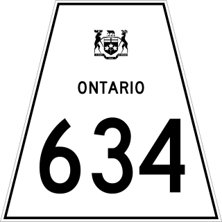
Secondary Highway 634, commonly referred to as Highway 634, is a remote highway in Northern Ontario that connects Highway 11 in Smooth Rock Falls to the Abitibi Canyon Generating Station in the community of Abitibi Canyon, Ontario. It is the second highway in Ontario to be designated Highway 634, with the original Highway 634 being near Sudbury. The current routing was at first designated as Highway 807, but was renumbered in 1977. The road was re-aligned around the eastern part of Smooth Rock Falls in the mid-1990s.

Little Abitibi Provincial Park is a non-operating provincial park 66 kilometres (41 mi) north of Cochrane, Ontario. It holds a network of small lakes which run into the Little Abitibi River. The Little Abitibi River runs about 120 kilometres (75 mi) up into the Abitibi Canyon, where the Ontario Power Generation dams the river at Fraserdale, an abandoned railway town.
Kakabeka Generating Station is a hydroelectric facility operated by Ontario Power Generation on the bank of the Kaministiquia River, 2 km (1.2 mi) downstream from Kakabeka Falls in the community of Kakabeka Falls, Ontario, 30 km (19 mi) west of Thunder Bay. The plant provides energy to the city of Thunder Bay and area. The station is one of ten hydroelectric stations in Ontario Power Generation's Northwest Plant Group, and is remotely operated from Thunder Bay.
The Little Abitibi River is a river in northern Ontario. It runs about 120 kilometres (75 mi) up into the Abitibi Canyon, where Ontario Power Generation's Abitibi Canyon Generating Station dams the river at Fraserdale, an abandoned railway town.
Abitibi Power and Paper Company Limited was a forest products business based in Montreal, Quebec, that was founded in 1914. The firm was a mainstay of the Canadian newsprint industry in the first half of the 20th century, and now forms part of Abitibi-Consolidated.
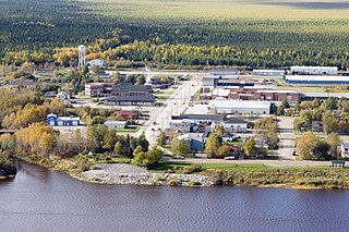
Otter Rapids, also known as White Otter Rapids, is an unincorporated place and dispersed rural community in geographic Pitt Township in the unorganized north part of Cochrane District in Ontario, Canada It is located 148.9 km (92.5 mi) south of Moosonee and 120 km (75 mi) north of Smooth Rock Falls.

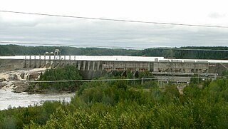
Abitibi Canyon Generating Station is a hydroelectric power plant owned by Ontario Power Generation on the Abitibi River. The station is located 80 km north of Smooth Rock Falls, within Pitt Township in Northern Unorganized Cochrane District, in Ontario, Canada.
CFDY-FM is a Canadian radio station that broadcasts a community radio format at 104.7 FM in Cochrane, Ontario.
The Kapuskasing River is a river in the James Bay drainage basin in Cochrane District and Algoma District in northeastern Ontario, Canada. The river is a left tributary of the Mattagami River.

The Black River is a river in Cochrane District and Timiskaming District in Northeastern Ontario, Canada. It is part of the James Bay drainage basin, and is a right tributary of the Abitibi River. The municipality of Black River-Matheson is named after the river.
Smoky Falls Generating Station is one of four stations in the Lower Mattagami River Hydroelectric Complex owned by Ontario Power Generation (OPG) and the Moose Cree First Nation. The station is approximately 85 km (53 mi) northeast of Kapuskasing in the Cochrane District of Northern Ontario. Smoky Falls was originally commissioned as a 54 MW generating station in 1931 by the Spruce Falls Power and Paper Company but it was sold to OPG's predecessor, Ontario Hydro, in 1991. OPG completed a $2.6 billion upgrade of the four Lower Mattagami dams in 2014 and 2015. The new Smoky Falls was commissioned in late 2014 with a 267.9 MW installed capacity.
References
- "Topographic Map sheet 42H13". Atlas of Canada . Natural Resources Canada. 6 February 2006. Archived from the original on 28 October 2008. Retrieved 6 December 2008.
- "Abitibi Canyon Generating Station". Northeast Plant Group. Ontario Power Generation. Archived from the original on 22 December 2008. Retrieved 6 December 2008.
