Wahgoshig First Nation

Last updated

Apitipi Anicinapek Nation (Wahgoshig First Nation)
Wahgoshig logo.png
Total population
250 (c.2009) [1]
Regions with significant populations
Flag of Canada (Pantone).svg  Canada (Flag of Ontario.svg  Ontario)
Apitipi Anicinapek Nation
Wahgoshig FN.JPG
Canada Ontario location map 2.svg
Red pog.svg
Apitipi Anicinapek Nation
Coordinates: 48°38′N79°58′W / 48.633°N 79.967°W / 48.633; -79.967
Country Flag of Canada (Pantone).svg  Canada
Province Flag of Ontario.svg  Ontario
District Cochrane
First NationAAN
Government
  ChiefJune Black
Area
  Land78.74 km2 (30.40 sq mi)
Population
 (2016) [2]
  Total144
  Density1.8/km2 (5/sq mi)
Website wahgoshigfirstnation.com

Apitipi Anicinapek Nation, formerly known as Wahgoshig First Nation, is an Algonquin Anicinape community, located near Matheson in Cochrane District in northeastern Ontario, Canada. In January 2008, the First Nation had 270 people registered with the nation, of which their on-reserve population was 121.

Contents

History

The first recorded reference to the native people about Lake Abitibi was in The Jesuit Relations in 1640. [3] They were a nomadic group of hunter-gatherers, whose traditional territory straddled a large segment of what is now northeastern Ontario and northwestern Quebec. Their hunting and trapping grounds extended and still extend east and northeast of Long Sault to Pierre, Harris, and Montreuil Lakes in Ontario, and on a parallel line into Quebec and as far east as Amos. The southernmost limit of the territory was a little south of Kirkland Lake in Ontario and Rouyn In Quebec. Cochrane, Ontario is the approximately western boundary.

Abitibi/Abitibis (Cree) and Timiskaming/Temiscamingues (Algonquin) territories in the seventeenth century. Abitibis et Temiscamingues.png
Abitibi/Abitibis (Cree) and Timiskaming/Témiscamingues (Algonquin) territories in the seventeenth century.

The Abitibi Indian Reserve No. 70 was created when the James Bay Treaty (Treaty 9) was signed at the Hudson's Bay Company post on Lake Abitibi in Quebec on June 7, 1906. It encompasses 7,786 ha (19,239 acres), or 78 km2 (30 sq mi). However, the treaty commissioners revealed that they were only authorized to negotiate with the Anishinaabe whose hunting grounds were in Ontario. The Abitibi Indians who were part of the same group, but whose hunting territory lay within Quebec, were told that negotiations for a reserve for them would occur later, but the Quebec government stalled that process for a considerable time after a treaty was signed with the Ontario band.

Two years after the signing of the James Bay Treaty, the Canadian federal government still had not been able to get Quebec to set aside a reserve for the Quebec Indians. It then arranged with the Quebec government to bring them under Treaty 9, which meant that they would receive annuities and would share in the revenues allocated to Abitibi 70, and income from this reserve was, and still is, divided on a per capita basis. This is the origin of much of the economic disparity that Wahgoshig First Nation contends with today; due to the way disbursements are set up through the federal government's intervention into their affairs, the Wahgoshig people receive only a minor share of any revenue that they may generate from natural resources on Wahgoshig Reserve. This has proved to be a disincentive towards developing the on-reserve natural resources.

Until 1972, the Department of Indian Affairs in Quebec administered the affairs of both the Abitibi-Dominion Band of Abitibi Indians (located in Quebec) and the Abitibi-Ontario Band of Abitibi Indians. From 1972 onward, Indian Affairs in Sudbury, Ontario, took over the affairs of the Abitibi-Ontario band. In 1979, the Abitibi-Dominion Band changed its name to Abitibiwinni First Nation and the Abitibi-Ontario Band became Wahgoshig First Nation.

Governance

The Wahgoshig First Nation have a Custom Electoral system of government. Elected officials have 4-year terms. The current elected officials consists of Chief June Black and six Councillors: Dave Morris, Chris Sackaney, Dannah Ellison, Shawna Malette, Joseph Matthews and Paul McKenzie. The Chief's term began in April 2016 and the council's term began in June 2016.

As a signatory to Treaty 9, the First Nation is a member of the Wabun Tribal Council, a Regional Chief's Council who is a member of the Nishnawbe Aski Nation, a Tribal Political Organization representing majority of First Nations in Northern Ontario. However, the Wahgoshig First Nation is a political member of the Algonquin Anishinabeg Nation Tribal Council since November 2000, together with other nations which Wahgoshig First Nation maintained strong historical ties.

There is an on-reserve village that occupies about 25 ha of the 70 ha flat land. West of the village, the land becomes undulating and it contains many wet swampy areas—ideal moose habitat. Moose, bears, grouse and other game are quite abundant in the area.

The reserve is served by Highway 101, which provides access to the 5.8 km long reserve road, approximately 50 km east of Matheson, Ontario, within a few miles of the western Quebec border. The north end of the reserve meets the south shore of Lake Abitibi, which separates the two provinces.

Canada census – Wahgoshig First Nation community profile
2016 2011
Population144 (+14.3% from 2011)126 (+10.5% from 2006)
Land area78.74 km2 (30.40 sq mi)78.70 km2 (30.39 sq mi)
Population density1.8/km2 (4.7/sq mi)1.6/km2 (4.1/sq mi)
Median age31.0 (M: 32.5, F: 25.9)26.8 (M: 26.7, F: 27.0)
Private dwellings63 (total) 46 (total) 
Median household income$39,424
References: 2016 [4] 2011 [5] earlier [6] [7]
N/A = Data Not Available.

Services

For the Abitibi village of about 25 ha, the First Nation provides the following services:

Wahgoshig is policed by the Nishnawbe-Aski Police Service, an Aboriginal-based service.

Related Research Articles

Aroland First Nation is a Ojibwa, Oji-Cree and cree First Nation within the Nishnawbe Aski Nation Territory and a signatory to Treaty 9, located in the Thunder Bay District approximately 20 kilometres west of Nakina. Aroland First Nation, has Indian reserve status, though the settlement itself is not a reserve. The Aroland First Nation is also a member of the Matawa First Nations Tribal Council.

<i>Treaty 9</i> Treaty between First Nations and Canadian Crown

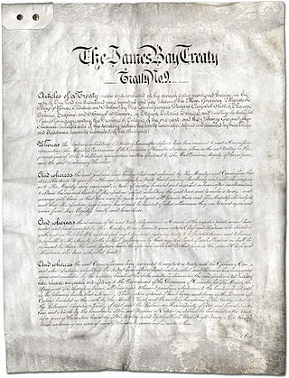
Treaty No. 9 is a numbered treaty first signed in 1905–1906 between Anishinaabe and Omushkegowuk Cree communities and the Canadian Crown, which includes both the government of Canada and the government of the province of Ontario. It is commonly known as the "James Bay Treaty," since the eastern edge of the treaty territory is the shore of James Bay in Northern Ontario.

Wapekeka First Nation is a First Nation band government in the Canadian province of Ontario. An Oji-Cree community in the Kenora District, the community is located approximately 450 kilometres northeast of Sioux Lookout. In January, 2008, the total registered population was 375, of which the on-reserve population was 355.

Cat Lake First Nation is an Ojibway First Nation reserve approximately 180 kilometres northwest of Sioux Lookout in northwestern Ontario, Canada, located on the central north shore of Cat Lake. As of 2021, their total registered population was 651 people.

<span class="mw-page-title-main">Timiskaming First Nation</span> First Nations reserve in Quebec, Canada

Timiskaming is a First Nations reserve in the Abitibi-Témiscamingue region of Quebec, Canada, just north of the head of Lake Timiskaming. It belongs to the Timiskaming First Nation, an Algonquin band. It is geographically within the Témiscamingue Regional County Municipality but administratively not part of it.

Webequie First Nation is located on the northern peninsula of Eastwood Island on Winisk Lake, 540 km (336 mi) north of Thunder Bay in Ontario, Canada. Webequie is a fly-in community with no summer road access. The primary way into the community is by air to Webequie Airport or winter road, which connects to the Northern Ontario Resource Trail. The First Nation have the 34,279 ha Webequie Indian reserve. The Webequie or Webiqui Indian Settlement also have reserve status. Webequie First Nation is a member of the Matawa First Nations, a Regional Chiefs' Council and a member of the Nishnawbe Aski Nation.

Poplar Hill First Nation is an Anishinaabe (Ojibway) First Nation band government, approximately 120 km north of Red Lake near the Ontario-Manitoba border. The First Nation is accessible by air and winter road. In May 2016, the First Nation had a registered population of 473 people.

<span class="mw-page-title-main">Bearskin Lake First Nation</span> Indian reserve in Ontario, Canada

Bearskin Lake First Nation is an Oji-Cree First Nation reserve in Kenora District, Ontario, Canada, located 425 kilometres (264 mi) north of Sioux Lookout. Bearskin First Nation's total registered population as of March 2014 was 900, of which their on-reserve population was 461.

<span class="mw-page-title-main">Nishnawbe Aski Nation</span>

Nishnawbe Aski Nation is a political organization representing 51 First Nation communities across Treaty 9 and Treaty 5 areas of Northern Ontario, Canada. Re-organized to its present form in 1981, NAN's original objective was "to represent the social and economic aspirations of our people at all levels of government in Canada and Ontario until such time as real effective action is taken to remedy our problems."

Marten Falls First Nation is an Anishinaabe First Nation reserve located in northern Ontario. The First Nation occupies communities on both sides of the Albany River in Northern Ontario, including Ogoki Post in the Cochrane District and Marten Falls in the Kenora District. As of December 2013, the First Nation had a total registered population of 728 people, of which their on-reserve population was 328 people.

Kingfisher First Nation is an Oji-Cree First Nation reserve located 350 kilometres (220 mi) north of Sioux Lookout, Ontario, Canada. It is accessible by air all year and by waterway in summer and ice roads in winter. As of December 2009, the First Nation had a total registered population of 500 people, the on-reserve population being 462. The community speaks the Oji-Cree language, but most of it is fluent in English as well.

McDowell Lake First Nation is a small Oji-Cree First Nation band government located in Northern Ontario, located approximately 155 km northeast of Red Lake, Ontario, Canada, on the central western shore of McDowell Lake. As of December, 2007, their total registered population was 52. It is part of the Keewaytinook Okimakanak Council and the Nishnawbe Aski Nation.

Chapleau Ojibway First Nation is an Ojibwa First Nation located near Chapleau Township, Sudbury District, Ontario, Canada. The First Nation have reserved for themselves the 67 ha Chapleau 61A Indian Reserve, 64.7 ha Chapleau 74 Indian Reserve and the 799.3 ha Chapleau 74A Indian Reserve. In September, 2007, their total registered population 39, of which their on-reserve population was 30.

Anishinaabe tribal political organizations are political consortiums of Anishinaabe nations that advocate for the political interests of their constituencies. Anishinaabe people of Canada are considered as First Nations, and of the United States as Native Americans.

The Muskrat Dam Lake First Nation is an Oji-Cree First Nation band government in Northern Ontario. They reside on the 1,939.7 hectares Muskrat Dam Lake reserve, located on Muskrat Dam Lake in the Kenora District. The community of Muskrat Dam, Ontario, is located on this reserve. In June 2008, their total registered population was 387 people, of which their on-reserve population was around 195.

The Ojibway Nation of Saugeen is an Ojibwa First Nation in the Canadian province of Ontario. The Nation is located in the Thunder Bay District, approximately 20 kilometres northwest of Savant Lake. In December, 2007, its total registered population was 206, of which the on-reserve population was 72. The community maintains strong ties with Mishkeegogamang First Nation

North Caribou Lake First Nation or Weagamow First Nation, sometimes also known as Round Lake First Nation, is an Oji-Cree First Nations band government who inhabit the Kenora District in northern Ontario, Canada. It is approximately 320 km (200 mi) by air north of Sioux Lookout. As of January 2008, the First Nations had a registered population of 928 people, of which their on-Reserve population was 677.

Brunswick House First Nation is an Ojibway-Cree First Nations in the Canadian province of Ontario, located in the Sudbury District, 157 km (97.6 mi) northeast of Sault Ste Marie, Ontario. The First Nation have reserved for themselves the 9,054.2 hectares Mountbatten 76A Indian Reserve and the 259.8 hectares Duck Lake 76B Indian Reserve. As of June, 2008, it had a registered population of 639 people, of which their on-Reserve population was 171 people.

<span class="mw-page-title-main">Kitigan Zibi</span> First Nations reserve in Quebec, Canada

Kitigan Zibi is a First Nations reserve of the Kitigan Zibi Anishinabeg First Nation, an Algonquin band. It is situated near the confluence of the Désert and Gatineau Rivers, and borders south-west on the Town of Maniwaki in the Outaouais region of Quebec, Canada. Having a total area of 210.09 km2 (81.12 sq mi), it is the largest Algonquin Nation in Canada in both area and population.

<span class="mw-page-title-main">Chapleau Cree First Nation</span>

Chapleau Cree First Nation is a Mushkegowuk Cree First Nation located by Chapleau Township, Sudbury District, Ontario, Canada. The First Nation have reserved for themselves the 108.1 hectares Chapleau 75 Indian Reserve and the 1,016.8 hectares Chapleau Cree Fox Lake Indian Reserve. As of 2019, their on-reserve population was 57 compared to 2011 with 79 and 2006 with 92.

References

  1. "Member Community Page". Algonquin Anishinabeg Nation Tribal Council. Archived from the original on 2012-05-11. Retrieved 2008-02-03.
  2. "Census Profile, 2016 Census Abitibi 70, Indian reserve". Statistics Canada . Retrieved June 10, 2019.
  3. Francis, Daniel (January 2007). "Lake Abitibi". The Canadian Encyclopedia. Archived from the original on 2016-03-04. Retrieved 2014-03-17.
  4. "2016 Community Profiles". 2016 Canadian Census . Statistics Canada. August 12, 2021. Retrieved 2019-06-10.
  5. "2011 Community Profiles". 2011 Canadian Census . Statistics Canada. March 21, 2019. Retrieved 2019-06-10.
  6. "2006 Community Profiles". 2006 Canadian Census . Statistics Canada. August 20, 2019.
  7. "2001 Community Profiles". 2001 Canadian Census . Statistics Canada. July 18, 2021.