
The Batchawana River is a river in Algoma and Sudbury Districts of Ontario, Canada, which empties into Batchawana Bay on Lake Superior north of Sault Ste. Marie, Ontario.

The Kenogami River is a river in the James Bay drainage basin in Thunder Bay and Cochrane districts in Northern Ontario, Canada, which flows north from Long Lake near Longlac to empty into the Albany River. The river is 320 kilometres (199 mi) in length and its name means "long water" in the Cree language. A portion of the river's headwaters have been diverted into the Lake Superior drainage basin.
The Albany River is a river in Northern Ontario, Canada, which flows northeast from Lake St. Joseph in Northwestern Ontario and empties into James Bay. It is 982 kilometres (610 mi) long to the head of the Cat River, tying it with the Severn River for the title of longest river in Ontario. Major tributaries include the Kenogami River and Ogoki River.
Constance Lake First Nation is an Oji-Cree First Nations band government located on the shores of Constance Lake near Hearst, Cochrane District in northeastern Ontario, Canada. It is directly north of the community of Calstock along a continuation of Ontario Highway 663. Constance Lake First Nation is home to close to 1605 members of Cree and Ojibway ancestry with approximately 820 living on reserve. It may also be known as "Home of Sonny Sutherland". The reserves, Constance Lake 92 and English River 66, total 7,686 acres (3,110 ha) in size.

Kabinakagami Lake is a lake in the Unorganized North Part of Algoma District in northeastern Ontario, Canada. The lake is on the Kabinakagami River and is part of the James Bay drainage basin. It is located northwest of the Chapleau Crown Game Preserve, and about 17 kilometres (11 mi) southwest of the settlement of Oba and 100 kilometres (62 mi) southwest of the town of Hearst.
Summit Lake is a lake in the James Bay drainage basin in the Unorganized North Part of Algoma District in northeastern Ontario, Canada. It is the source of the Kabinakagami River, which flows via the Kenogami River and Albany River to James Bay. The lake is about 1.0 kilometre (0.6 mi) long and 0.2 kilometres (0.1 mi) wide, lies at an elevation of 442 metres (1,450 ft), and there are no significant inflows.

Island Lake is a rural settlement in the Unorganized North Part of Algoma District in northeastern Ontario, Canada. It is part of the Aweres local services board and is about 5 kilometres (3 mi) northeast of the community of Heyden, which sits on Ontario Highway 17, and is also 21.1 kilometers northeast of Sault Ste. Marie, the district seat. The settlement is at the junction of Ontario Highway 552 and Ontario Highway 556, and the Algoma Central Railway passes through the community. Island Lake was once home to Canadian Military installments—some buildings still remain in the area, however much have been either torn down or completely renovated. Island lake was also once the location of a train station—part of the Algoma Central and Hudson Bay Railway's Main Line.

The Blanche River is a river in the Saint Lawrence River drainage basin in Timiskaming District in northeastern Ontario, Canada. The river is a tributary of Lake Timiskaming and its name is from the French for the colour "white".

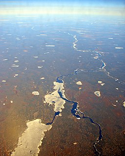
Mammamattawa is a dispersed rural community and unincorporated place in the Unorganized North Part of Cochrane District in northeastern Ontario, Canada. It is located at the mouth of the Kabinakagami River at the Kenogami River, just 2 kilometres (1.2 mi) downstream of the mouth of the Nagagami River at the Kenogami, in the James Bay drainage basin.

The Kapuskasing River is a river in the James Bay drainage basin in Cochrane District and Algoma District in northeastern Ontario, Canada. The river is a left tributary of the Mattagami River.
Flintdale is an unincorporated place and railway point in geographic Selwyn Township in Unorganized North Cochrane District in northeastern Ontario, Canada.
Blanche is an unincorporated place and railway point in geographic Selwyn Township in the Unorganized North Part of Cochrane District in northeastern Ontario, Canada.
Wilgar is an unincorporated place and railway point in geographic Henderson Township in Unorganized North Cochrane District in northeastern Ontario, Canada.
Pagwa is an unincorporated place and railway point in geographic Bicknell Township in Unorganized North Cochrane District in northeastern Ontario, Canada. It is named for the Pagwachuan River.
Lynx is an unincorporated place and railway point in the Unorganized North Part of Cochrane District in northeastern Ontario, Canada.
Jobrin is an unincorporated place and community in the Unorganized North Part of Cochrane District in northeastern Ontario, Canada.

The Groundhog River is a river in Cochrane District and Sudbury District in Northeastern Ontario, Canada. The river is in the James Bay drainage basin and is a left tributary of the Mattagami River.
Fox Lake is a lake in geographic Bannerman Township, Cochrane District in Northeastern Ontario, Canada. It is in the James Bay drainage basin, and is the source of the Fox River.
English River 66 is a First Nations reserve in Cochrane District, Ontario, Canada, located adjacent to the settlement of Mammamattawa and just downstream of the mouth of the Kabinakagami River at the Kenogami River. It is one of two reserves of the Constance Lake First Nation, and has an area of 3,108 hectares.
Strickland Creek is a stream in both the municipality of Fauquier-Strickland and Unorganized North Cochrane District, Cochrane District in Northeastern Ontario, Canada. It is in the James Bay drainage basin and is a right tributary of Moonbeam Creek.
