
Canada has a vast geography that occupies much of the continent of North America, sharing a land border with the contiguous United States to the south and the U.S. state of Alaska to the northwest. Canada stretches from the Atlantic Ocean in the east to the Pacific Ocean in the west; to the north lies the Arctic Ocean. Greenland is to the northeast with a shared border on Hans Island. To the southeast Canada shares a maritime boundary with France's overseas collectivity of Saint Pierre and Miquelon, the last vestige of New France. By total area, Canada is the second-largest country in the world, after Russia. By land area alone, however, Canada ranks fourth, the difference being due to it having the world's largest proportion of fresh water lakes. Of Canada's thirteen provinces and territories, only two are landlocked while the other eleven all directly border one of three oceans.

The Canadian Shield, also called the Laurentian Shield or the Laurentian Plateau, is a geologic shield, a large area of exposed Precambrian igneous and high-grade metamorphic rocks. It forms the North American Craton, the ancient geologic core of the North American continent. Glaciation has left the area with only a thin layer of soil, through which exposures of igneous bedrock resulting from its long volcanic history are frequently visible. As a deep, common, joined bedrock region in eastern and central Canada, the shield stretches north from the Great Lakes to the Arctic Ocean, covering over half of Canada and most of Greenland; it also extends south into the northern reaches of the continental United States.

Hudson Bay, sometimes called Hudson's Bay, is a large body of saltwater in northeastern Canada with a surface area of 1,230,000 km2 (470,000 sq mi). It is located north of Ontario, west of Quebec, northeast of Manitoba, and southeast of Nunavut, but politically entirely part of Nunavut. It is an inland marginal sea of the Arctic Ocean. The Hudson Strait provides a connection between the Labrador Sea and the Atlantic Ocean in the northeast, while the Foxe Channel connects Hudson Bay with the Arctic Ocean in the north. The Hudson Bay drainage basin drains a very large area, about 3,861,400 km2 (1,490,900 sq mi), that includes parts of southeastern Nunavut, Alberta, Saskatchewan, Ontario, Quebec, all of Manitoba, and parts of the U.S. states of North Dakota, South Dakota, Minnesota, and Montana. Hudson Bay's southern arm is called James Bay.
James Bay is a large body of water located on the southern end of Hudson Bay in Canada. It borders the provinces of Quebec and Ontario, and is politically part of Nunavut. Its largest island is Akimiski Island.

A bog or bogland is a wetland that accumulates peat as a deposit of dead plant materials – often mosses, typically sphagnum moss. It is one of the four main types of wetlands. Other names for bogs include mire, mosses, quagmire, and muskeg; alkaline mires are called fens. A bayhead is another type of bog found in the forest of the Gulf Coast states in the United States. They are often covered in heath or heather shrubs rooted in the sphagnum moss and peat. The gradual accumulation of decayed plant material in a bog functions as a carbon sink.

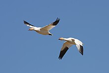
Wapusk National Park is Canada's 37th national park, established in 1996. The name comes from the Cree word for polar bear (wâpask).

The Hudson Bay drainage basin is the drainage basin in northern North America where surface water empties into the Hudson Bay and adjoining waters. Spanning an area of about 3,861,400 square kilometres (1,490,900 sq mi) and with a mean discharge of about 30,900 m3/s (1,090,000 cu ft/s), the basin is almost entirely within Canada. It encompasses parts of the Canadian Prairies, Central Canada, and Northern Canada. A small area of the basin is in the northern part of the Midwestern United States.
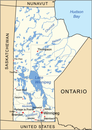
The geography of Manitoba addresses the easternmost of the three prairie Canadian provinces, located in the longitudinal centre of Canada. Manitoba borders on Saskatchewan to the west, Ontario to the east, Nunavut to the north, and the American states of North Dakota and Minnesota to the south. Although the border with Saskatchewan appears straight on large-scale maps, it actually has many right-angle corners that give the appearance of a slanted line. In elevation, Manitoba ranges from sea level on Hudson Bay to 2727 ft (831 m) on top of Baldy Mountain. The northern sixty percent of the province is on the Canadian Shield. The northernmost regions of Manitoba lie permafrost, and a section of tundra bordering Hudson Bay.

The Great Lakes-St. Lawrence Lowlands, or simply St. Lawrence Lowlands, is a physiographic region of Eastern Canada that comprises a section of southern Ontario bounded on the north by the Canadian Shield and by three of the Great Lakes — Lake Huron, Lake Erie and Lake Ontario — and extends along the St. Lawrence River to the Strait of Belle Isle and the Atlantic Ocean. The lowlands comprise three sub-regions that were created by intrusions from adjacent physiographic regions — the West Lowland, Central Lowland and East Lowland. The West Lowland includes the Niagara Escarpment, extending from the Niagara River to the Bruce Peninsula and Manitoulin Island. The Central Lowland stretches between the Ottawa River and the St. Lawrence River. The East Lowland includes Anticosti Island, Îles de Mingan, and extends to the Strait of Belle Isle.
Southern James Bay is a coastal wetland complex in northeastern Ontario, Canada bordering James Bay and Quebec. It was designated as a wetland of international importance via the Ramsar Convention on May 27, 1987. The shallow waters of the James Bay region represent an important late autumn staging area for migratory, Arctic-breeding waterbirds.

The Arctic Archipelago Marine Ecozone, as defined by the Commission for Environmental Cooperation (CEC), is a marine ecozone in the Canadian Arctic, encompassing Hudson Bay, James Bay, the internal waters and some shores of the islands in the Canadian Arctic Archipelago, and the shores of the territories, northern Ontario and western Quebec. Early exploration of these waters by Europeans were conducted to find a passage to the Orient, now referred to as the Northwest Passage.

The Taiga Shield Ecozone, as defined by the Commission for Environmental Cooperation (CEC), is an ecozone which stretches across Canada's subarctic region. Some regions exhibit exposed Precambrian bedrock of the Canadian Shield, the oldest of the world's geological formations. The world's oldest rocks, dating to four billion years, are found in the Canadian Shield north of Great Slave Lake.

Canada's boreal forest is a vast region comprising about one third of the circumpolar boreal forest that rings the Northern Hemisphere, mostly north of the 50th parallel. Other countries with boreal forest include Russia, which contains the majority; the United States in its northernmost state of Alaska; and the Scandinavian or Northern European countries. In Europe, the entire boreal forest is referred to as taiga, not just the northern fringe where it thins out near the tree line. The boreal region in Canada covers almost 60% of the country's land area. The Canadian boreal region spans the landscape from the most easterly part of the province of Newfoundland and Labrador to the border between the far northern Yukon and Alaska. The area is dominated by coniferous forests, particularly spruce, interspersed with vast wetlands, mostly bogs and fens. The boreal region of Canada includes eight ecozones. While the biodiversity of regions varies, each ecozone has characteristic native flora and fauna.

The Eastern Great Lakes and Hudson Lowlands region extends along the south shores of Lake Erie and Lake Ontario and the St. Lawrence River to Lake Champlain, and south down the Hudson River. It is primarily within the state of New York, with smaller portions in Vermont, Pennsylvania, and Ohio. In the north it meets the Mixedwood Plains Ecozone of Canada in eastern Ontario and southern Quebec. It is mostly temperate deciduous forest and agricultural land.

The Mixedwood Plains Ecozone is the Canadian ecozone with the most southern extent, covering all of southwestern Ontario, and parts of central and northeastern Ontario and southern Quebec along the Saint Lawrence River. It was originally dominated by temperate deciduous forest growing mostly on limestone covered by glacial till. It is the smallest ecozone in Canada, but it includes the country's most productive industrial and commercial region, and is home to nearly half of Canada's population, including its two largest cities, Toronto, Ontario and Montreal, Quebec. Hence, little of the original forest cover remains, making protection of the remaining forests a high conservation priority. This ecozone includes two regions described by J.S. Rowe in his classic Forest Regions of Canada: the entire Deciduous Forest Region, and the southern portions of the Great Lakes-St. Lawrence Forest Region. In the province of Ontario, the Ontario Ministry of Natural Resources maps this area as Site Regions 6E and 7E.

The Hudson Plains Ecoregion is a vast, flat, and waterlogged landscape. This ecoregion covers a 369,000 square kilometer area along the south shoreline of the Hudson Bay, which includes the Canadian provinces of Eastern Quebec, Northern Ontario and Western Manitoba. Because of the location of the ecoregion, winter prevails for many months of the year and rising temperatures, along with melting ice, makes fog common. The short summers provide a home for thousands of migrating birds. The region is used by humans for its mineral resources and hydroelectric power as a result of the abundance of water and emergent societal needs. Though relatively uninhabited and undisturbed, the natural resources of the Hudson Plains are still subject to anthropogenic activities. Its climatic, geographic, and evolutionary patterns categorize it as one of many ecoregions in North America.

The Southern Hudson Bay taiga is a terrestrial ecoregion, as classified by the World Wildlife Fund, which extends along the southern coast of Hudson Bay and resides within the larger taiga biome. The region is nearly coterminous with the Hudson Plain, a Level I ecoregion of North America as designated by the Commission for Environmental Cooperation (CEC) in its North American Environmental Atlas.
Sturgeon Bay Provincial Park is a provincial park on the western shore of Lake Winnipeg in Manitoba, Canada. The park is considered to be a Class Ib protected area under the IUCN protected area management categories. It is 144.9 km2 (55.9 sq mi) in size.
