Southern Hudson Bay taiga

Last updated
Southern Hudson Bay taiga
Geburtshohlen 1999-07-02.jpg
Black spruce forest in Wapusk National Park, Manitoba. Note the presence of polar bear dens.
Southern Hudson Bay Taiga map.svg
Extent of the Southern Hudson Bay taiga ecoregion
Ecology
Realm Nearctic
Biome Boreal forests/taiga
Borders
Bird species180
Mammal species45
Geography
Area373,735 km2 (144,300 sq mi)
Country Canada
Province
Elevation120 m asl
Coordinates 53°56′35″N85°23′24″W / 53.943°N 85.390°W / 53.943; -85.390
Climate type Humid continental and subarctic
Conservation
Conservation status Relatively Stable/Intact
Habitat loss1% [1]
Protected9.32% [1]
Hudson Plain
Picea mariana taiga.jpg
Black Spruce ( Picea mariana ) forest typical of this ecozone
Ecology
Borders
Geography
Area373,718 km2 (144,293 sq mi)
Country Canada
Provinces
Climate type Subarctic

The Southern Hudson Bay taiga is a terrestrial ecoregion, as classified by the World Wildlife Fund, which extends along the southern coast of Hudson Bay and resides within the larger taiga biome. The region is nearly coterminous with the Hudson Plain, a Level I ecoregion of North America as designated by the Commission for Environmental Cooperation (CEC) in its North American Environmental Atlas .

Contents

Entirely located in Canada, the Southern Hudson Bay taiga covers an area of approximately 373,735 square kilometres (144,300 sq mi) and crosses the provinces of Manitoba, Ontario, and the western portion of Quebec. [2] Various islands in James Bay which belong to Nunavut are also considered to be part of the ecoregion. It includes the largest continuous wetland in the world. [3] It covers nearly a quarter of Ontario's landmass, and 3.6% of Canada's total area, [4] [5]

Its historical prominence is due to the harshness endured by pioneer explorers who established fortifications for Hudson's Bay Company, and as a result of regional wars between France and Britain. [5] Today, it is primarily noted for the well-known Polar Bear Provincial Park, and to a lesser extent Wapusk National Park, as well as its vast wetlands which are used by migratory birds.

Geography

The Southern Hudson Bay taiga is contained within the conceptually larger Nearctic realm and possesses a number of neighbouring ecoregions including the Eastern Canadian Shield taiga, Northern Canadian Shield taiga, Central Canadian Shield forests, and Midwestern Canadian Shield forests. Prominent geological features in the region include the Hudson Platform and an underlying layer of Paleozoic limestone bedrock. [1] Its soils, which are primarily Gelic and Dystric Histosols and Eutric Gleysols, are characterized by shallow layers of permafrost, slightly acidic pH levels, and hydromorphic conditions. [6] The Southern Hudson Bay taiga represents an area where a number of hydrologically significant rivers, such as the Nelson River and the Mattagami River, deposit their headwaters from farther inland into the Arctic Ocean via Hudson Bay. [7] Alternative geographic classifications also commonly refer to the region as the Hudson Bay Lowlands.

The Palaeozoic and Proterozoic sedimentary deposits overlaying the bedrock [3] have formed into a wide and level plain characterised by raised beaches and river deltas, [8] with an elevation rarely exceeding 120 m. [9] The relatively flat land slopes gently toward the two bays, which act as a drainage basin for the region. However, the relatively poor drainage system has spurred the natural development of numerous wetlands. It is encircled by the Canadian Shield, with which it overlaps in a few areas to the east and west. [10]

To its north is the cold Arctic Archipelago Marine ecozone, and to the south is the milder Boreal Shield. Hence, this ecozone is transitional, [9] which is easily evident as it transforms from barren tundra in the north to open taiga forests in the south. [3] These forests resemble those of the boreal zone, with sparser vegetation. [9]

Thousands of depressions carved by retreating glaciers have become lakes and wetlands. [10] The Hudson Plains is also noted for coastal marshes and extensive tidal flats, [10] with tidal marshes along the coast of Hudson Bay. [8] Belts of raised beaches are evident where rebound from glacier retreat is most prominent. [9]

Climate

The ecoregion has a subarctic climate under the Köppen-Geiger climate classification system and is significantly influenced by the adjacent marine area of Hudson Bay, which features cold and moisture-laden low-pressure systems. [11] Typical seasonal conditions in the Southern Hudson Bay taiga consist of brief, cool summers with significant daylight, and cold winters with prolonged darkness. [12] Frigid polar high-pressure air masses commonly reach the area. Average temperatures range from 10.5°C to 11.5°C during summer months, -19°C to -16°C during winter months, and -5°C to -2°C throughout the year. Precipitation levels vary greatly within the region due to differences in temperature, with the eastern and western areas receiving an annual average of 500-800 mm and the northern areas as little as 400 mm. [1] [11]

Flora and fauna

Referred to as an "insect-infested landscape of bog and fog", [5] it teems with large insect populations that are a food source for migratory waterbirds. [9] The Hudson Plains have become "notorious for their populations of biting insects". [3] Vegetation is somewhat limited, with the northern areas abutting the Arctic Archipelago Marine being nearly treeless, whereas the southern extent, adjacent to the Boreal Shield, have open forest. [13] Alder, willow, black spruce and tamarack are the most common plant species in the treed bogs and fens of the Hudson Plains, [10] [13] whereas sphagnum and shrubs such as crowberry and blueberry dominate the open bogs to the north, [8] [13] with white spruce appearing further south. Poorly drained areas produce dense sedge, moss and lichen cover. [10]

The Hudson Plains also represent the southern extent of the polar bears yearly migratory route, which reaches the northwestern coast of Ontario. In autumn, polar bears migrate to the ice pack forming along the coast of Hudson Bay. [14] The bears then follow the Hudson Bay Coast toward Churchill, Manitoba. Mammals such as moose, woodland caribou and black bears are comfortable in this environment, but smaller mammals are more common, including muskrats, weasels, Arctic foxes, martens, and fishers. [11] [13]

The adjacent marine ecozone of the Arctic Archipelago Marine supports mammal populations of walrus and bearded, harbour and ringed seals. [11]

Millions of migratory shorebirds stage and nest in multiple areas of the Hudson Plains, particularly in three areas within Southern James Bay: Akimiski Island, and the migratory bird sanctuaries at Hannah Bay and the mouth of the Moose River. Representative species include the snow goose, Canada goose, king eider, swan, loon, gyrfalcon, and peregrine falcon. [11] [13]

Belonging to the circumboreal floristic region, the Southern Hudson Bay taiga contains a total of 1178 different plant species – none of which are considered endemic to the area. [15] The major plant communities in this ecoregion, which are characteristic of the taiga biome, primarily consist of black spruce ( Picea mariana ) and tamarack ( Larix laricina ) forests. Species which commonly dominate the forest undergrowth are birch ( Betula ), willow ( Salix ), and marsh Labrador tea ( Rhododendron tomentosum ). Due to the tundra conditions in the northern extent of the region, a latitudinal gradient of plant biodiversity exists which increases towards the south. Wetlands in this ecoregion are estimated to occupy between 50 and 75% of the land area. [1]

In terms of species composition, the animal populations of the Southern Hudson Bay taiga are largely transitional between those of the Central Canadian Shield forests and Low Arctic tundra. The region contains a total of 45 mammal species, 160 bird species, and 2 reptile species. [15] The coastal areas of southern Hudson Bay are home to polar bears ( Ursus marinus ), arctic foxes ( Vulpes lagopus ), seals ( Phocidae ), beluga whales ( Delphinapterus leucas ), and tundra swans ( Cygnus columbianus ). Approaching the Central Canadian Shield forests near James Bay, the ecoregion gives way to moose ( Alces ), black bears ( Ursus americanus ), wolves ( Canis lupus ), and Canada lynx ( Lynx canadensis ). Other species which can be found throughout the entirety of the ecoregion are caribou ( Rangifer tarandus ), snowshoe hare ( Lepus americanus ), and Canada goose ( Branta canadensis ). [1]

Human use

With an average population density estimated at less than 1 person/km2, the majority of the human population in the Southern Hudson Bay taiga is concentrated in a number of smaller towns and communities located along the southern coast of Hudson Bay. [15] These include Churchill, Moosonee, and Moose Factory as well as the First Nation communities of Fort Severn, Fort Albany, and Attawapiskat. Much of the ecoregion is the traditional territory of the Cree, Dene, Inuit, and Métis peoples. [16] The region also witnessed the development of the Hudson's Bay Company during the 17th century and played an integral role in the North American fur trade. It was part of a larger area referred to as Rupert's Land in which the Hudson's Bay Company had exclusive commercial rights until it was sold to the Canadian government in 1870. [17]

Conservation and threats

The World Wildlife Fund has classified the conservation status of the ecoregion as relatively stable/intact as a result of its sparse, low-impact human presence. It is therefore not part of the WWF's Global 200 list of ecoregions most in need of conservation efforts. Approximately 9.32% of all lands in the Southern Hudson Bay taiga are considered protected including Polar Bear Provincial Park, Wapusk National Park, and Jog Lake Conservation Reserve. As a result of its more northern latitude, the area is not subject to intense logging or deforestation pressures. The primary conservation concerns for the region surround the proposed hydroelectric projects near James Bay and the regulation of hunt camps. [1] Estimates indicate that the Southern Hudson Bay taiga will experience an increase in temperature of 3.39°C and an increase in precipitation of 13.32 mm by 2050 as a result of climate change. [15]

See also

Related Research Articles

<span class="mw-page-title-main">Nearctic realm</span> Biogeographic realm encompassing temperate North America

The Nearctic realm is one of the eight biogeographic realms constituting the Earth's land surface.

<span class="mw-page-title-main">James Bay</span> Bay on the southern end of the Hudson Bay, Canada

James Bay is a large body of water located on the southern end of Hudson Bay in Canada. Both bodies of water extend from the Arctic Ocean, of which James Bay is the southernmost part. Despite bordering the Canadian provinces of Quebec and Ontario, the bay and the islands within it, the largest of which is Akimiski Island, are politically part of Nunavut.

<span class="mw-page-title-main">Moose River (Ontario)</span> Tributary of South shore of James Bay, flowing in North-East of Ontario, in Canada.

The Moose River is a river in the Hudson Plains ecozone of northern Ontario, Canada. The river flows 100 km northeast from the confluence of the Mattagami and Missinaibi Rivers into James Bay. Its drainage basin is 108,500 square kilometres (41,900 sq mi) and it has a mean discharge rate of 1,370 cubic metres (48,000 cu ft). Its full length is 547 kilometres (340 mi) if counted from the head of the Mattagami River.

The Anderson River is in the Northwest Territories in northern Canada. It originates in lakes northwest of Great Bear Lake; its headwaters are possibly on the north side of Colville Lake in the vicinity of the hamlet of Colville Lake. It flows north and west in the area between the Mackenzie and Coppermine Rivers. Its mouth is on the Beaufort Sea on the Arctic Ocean near the eastern end of Liverpool Bay at about 70 degrees north latitude. Its main tributary is the Carnwath River. Originally known as the Beghula River it was renamed to the Anderson River in 1857 by Roderick MacFarlane after James Anderson, both of the Hudson's Bay Company. Anderson was the Chief Factor in the Mackenzie District.

<span class="mw-page-title-main">Boreal Shield Ecozone (CEC)</span> Largest ecozone in Canada, stretching from Saskatchewan to Newfoundland

The Boreal Shield Ecozone, as defined by the Commission for Environmental Cooperation (CEC), is the largest ecozone in Canada. Covering 1.8 million square kilometres it covers almost 20% of Canada's landmass, stretching from northern Saskatchewan to Newfoundland.

<span class="mw-page-title-main">Geography of Manitoba</span>

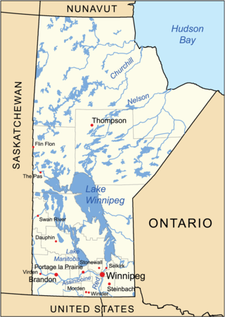
The geography of Manitoba addresses the easternmost of the three prairie Canadian provinces, located in the longitudinal centre of Canada. Manitoba borders on Saskatchewan to the west, Ontario to the east, Nunavut to the north, and the American states of North Dakota and Minnesota to the south. Although the border with Saskatchewan appears straight on large-scale maps, it actually has many right-angle corners that give the appearance of a slanted line. In elevation, Manitoba ranges from sea level on Hudson Bay to 2727 ft (831 m) on top of Baldy Mountain. The northern sixty percent of the province is on the Canadian Shield. The northernmost regions of Manitoba lie permafrost, and a section of tundra bordering Hudson Bay.

<span class="mw-page-title-main">Arctic Cordillera</span> Terrestrial ecozone in northern Canada

The Arctic Cordillera is a terrestrial ecozone in northern Canada characterized by a vast, deeply dissected chain of mountain ranges extending along the northeastern flank of the Canadian Arctic Archipelago from Ellesmere Island to the northeasternmost part of the Labrador Peninsula in northern Labrador and northern Quebec, Canada. It spans most of the eastern coast of Nunavut with high glaciated peaks rising through ice fields and some of Canada's largest ice caps, including the Penny Ice Cap on Baffin Island. It is bounded to the east by Baffin Bay, Davis Strait and the Labrador Sea while its northern portion is bounded by the Arctic Ocean.

<span class="mw-page-title-main">Hudson Bay Lowlands</span> Wetland located between the Canadian Shield and Hudson Bay

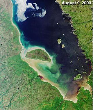
The Hudson Bay Lowlands is a vast wetland located between the Canadian Shield and southern shores of Hudson Bay and James Bay. Most of the area lies within the province of Ontario, with smaller portions reaching into Manitoba and Quebec. Many wide and slow-moving rivers flow through this area toward the saltwater of Hudson Bay: these include the Churchill, Nelson and Hayes in Manitoba, Severn, Fawn, Winisk, Asheweig, Ekwan, Attawapiskat, and Albany in Ontario, and the Harricana, Rupert and Eastmain in Quebec. This is the largest wetland in Canada, and one of the largest in the world. The region can be subdivided into three bands running roughly northwest to southeast: the Coastal Hudson Bay Lowland, Hudson Bay Lowland, and James Bay Lowland.

<span class="mw-page-title-main">Arctic Archipelago Marine Ecozone (CEC)</span> Canadian marine ecozone

The Arctic Archipelago Marine Ecozone, as defined by the Commission for Environmental Cooperation (CEC), is a marine ecozone in the Canadian Arctic, encompassing Hudson Bay, James Bay, the internal waters and some shores of the islands in the Canadian Arctic Archipelago, and the shores of the territories, northern Ontario and western Quebec. Early exploration of these waters by Europeans were conducted to find a passage to the Orient, now referred to as the Northwest Passage.

<span class="mw-page-title-main">Taiga Plains Ecozone (CEC)</span>

The Taiga Plain Ecozone, as defined by the Commission for Environmental Cooperation (CEC), is a Canadian terrestrial ecozone that covers most of the western Northwest Territories, extending to northwest Alberta, northeast British Columbia and slightly overlapping northeastern Yukon.

<span class="mw-page-title-main">Boreal forest of Canada</span> Canadian biome characterized by coniferous forests

Canada's boreal forest is a vast region comprising about one third of the circumpolar boreal forest that rings the Northern Hemisphere, mostly north of the 50th parallel. Other countries with boreal forest include Russia, which contains the majority; the United States in its northernmost state of Alaska; and the Scandinavian or Northern European countries. In Europe, the entire boreal forest is referred to as taiga, not just the northern fringe where it thins out near the tree line. The boreal region in Canada covers almost 60% of the country's land area. The Canadian boreal region spans the landscape from the most easterly part of the province of Newfoundland and Labrador to the border between the far northern Yukon and Alaska. The area is dominated by coniferous forests, particularly spruce, interspersed with vast wetlands, mostly bogs and fens. The boreal region of Canada includes eight ecozones. While the biodiversity of regions varies, each ecozone has a characteristic native flora and fauna.

<span class="mw-page-title-main">Eastern Canadian Shield taiga</span> Taiga ecoregion of Labrador and Quebec, Canada

The Eastern Canadian Shield taiga is an ecoregion of Canada as defined by the World Wildlife Fund (WWF) categorization system.

<span class="mw-page-title-main">Hudson Plains Ecoregion</span>

The Hudson Plains Ecoregion is a vast, flat, and waterlogged landscape. This ecoregion covers a 369,000 square kilometer area along the south shoreline of the Hudson Bay, which includes the Canadian provinces of Eastern Quebec, Northern Ontario and Western Manitoba. Because of the location of the ecoregion, winter prevails for many months of the year and rising temperatures, along with melting ice, makes fog common. The short summers provide a home for thousands of migrating birds. The region is used by humans for its mineral resources and hydroelectric power as a result of the abundance of water and emergent societal needs. Though relatively uninhabited and undisturbed, the natural resources of the Hudson Plains are still subject to anthropogenic activities. Its climatic, geographic, and evolutionary patterns categorize it as one of many ecoregions in North America.

<span class="mw-page-title-main">Canadian Arctic tundra</span>

The Canadian Arctic tundra is a biogeographic designation for Northern Canada's terrain generally lying north of the tree line or boreal forest, that corresponds with the Scandinavian Alpine tundra to the east and the Siberian Arctic tundra to the west inside the circumpolar tundra belt of the Northern Hemisphere.

<span class="mw-page-title-main">Northwest Territories taiga</span> Taiga ecoregion located in the Northwest Territories and Yukon provinces of Canada

The Northwest Territories taiga ecoregion (WWF:NA0614) is located in the Northwest Territories and Yukon provinces of Canada. It covers forest and tundra along the Mackenzie River Valley and the surrounding highlands in the southern portion of the valley.

<span class="mw-page-title-main">High Arctic tundra</span> Tundra ecoregion of Nunavut and the Northwest Territories, Canada

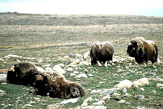
The High Arctic tundra ecoregion covers most of Canada's northern Arctic Archipelago - from the Queen Elizabeth Islands nearest to Greenland in the northeast, and down through the center of Baffin Island. Much of the northern islands are covered in ice, and the climate is very dry with as little as 50 mm/year in places. The ecoregion has very little human habitation, and most of the non-ice terrain is moss and lichen cover. The region supports viable populations of arctic mammals such as muskox, arctic wolves, arctic foxes, arctic hares, polar bears, and caribou.

<span class="mw-page-title-main">Low Arctic tundra</span> Tundra ecoregion of Canada

The Low Arctic tundra ecoregion covers a rolling landscape of shrubby tundra vegetation along the northern edge of the mainland Canada along the border of the Northwest Territories and Nunavut, and a small portion in Quebec on the northeast coast of Hudson Bay. The region is important for large herds of caribou and other large mammals, and for large nesting colonies of birds such as snow geese. The region is mostly intact, with 95% remaining intact.

<span class="mw-page-title-main">Middle Arctic tundra</span> Tundra ecoregion of Canada

The Middle Arctic tundra ecoregion covers a broad stretch of northern Canada - the southern islands of the Arctic Archipelago, plus the northern mainland of Nunavut and, across Hudson Bay to the east, a portion of northern Quebec. This is the coldest and driest ecoregion in Canada, and can be referred to as a 'polar desert'. It is an important region for breeding and migratory birds, and supports 80% of the world's muskox.

<span class="mw-page-title-main">Torngat Mountain tundra</span>

The Torngat Mountain tundra ecoregion covers the Torngat Mountains on the northeastern tip of the Labrador Peninsula where the provinces of Quebec and Newfoundland and Labrador meet. The mountains feature glacially carved U-shaped valleys and deep fjords. The vegetation over most of the territory is that of arctic tundra, herbaceous cover, or bare rock. The region supports seasonal polar bears, black bears, and caribou. The Atlantic coast is on the Atlantic Flyway for migratory birds.

References

  1. 1 2 3 4 5 6 7 "Southern Hudson Bay taiga | Ecoregions | WWF". World Wildlife Fund. Retrieved 2019-04-02.
  2. Olson, D. M, E. Dinerstein; et al. (2001). "Terrestrial Ecoregions of the World: A New Map of Life on Earth". BioScience . 51 (11): 933–938. doi: 10.1641/0006-3568(2001)051[0933:TEOTWA]2.0.CO;2 .{{cite journal}}: CS1 maint: multiple names: authors list (link)
  3. 1 2 3 4 Bernhardt, Torsten. "Hudson Plains". Canada's Ecozones, Canadian Biodiversity project. McGill University, Redpath Museum. Archived from the original on 2008-02-04. Retrieved 2008-02-01.
  4. "The State of Canada's Environment — 1996". Environment Canada . Retrieved 2008-02-01.[ permanent dead link ]
  5. 1 2 3 "The Wetlands". Hudson Plains Ecozone. Environment Canada. Archived from the original on 2007-08-04. Retrieved 2008-02-01.
  6. "FAO/UNESCO Soil Map of the World | FAO SOILS PORTAL | Food and Agriculture Organization of the United Nations". www.fao.org. Retrieved 2019-04-02.
  7. Canada, Natural Resources (2013-10-07). "The Atlas of Canada". www.nrcan.gc.ca. Retrieved 2019-04-02.
  8. 1 2 3 "State of the Environment Reports". Manitoba Environment. 1997. Archived from the original on 2007-08-11. Retrieved 2008-02-01.
  9. 1 2 3 4 5 "Hudson Plains". The Ecozones of Ontario. Environmental Commissioner of Ontario. Archived from the original on 2007-09-23. Retrieved 2008-02-01.
  10. 1 2 3 4 5 "Taiga Shield & Hudson Plains". Canadian Bird Conservation Regions. Bird Studies Canada. Archived from the original on 2008-09-08. Retrieved 2008-02-01.
  11. 1 2 3 4 5 "Hudson Plains Ecozone" (PDF). Parks Canada. Autumn 2003. Archived from the original (PDF) on 2011-06-05. Retrieved 2008-02-01.
  12. Wood, Eric F.; Berg, Alexis; Noemi Vergopolan; McVicar, Tim R.; Zimmermann, Niklaus E.; Beck, Hylke E. (2018-10-30). "Present and future Köppen-Geiger climate classification maps at 1-km resolution". Scientific Data. 5: 180214. Bibcode:2018NatSD...580214B. doi:10.1038/sdata.2018.214. PMC   6207062 . PMID   30375988.
  13. 1 2 3 4 5 "Ecozones". Canadian Wildlife Federation. Retrieved 2008-02-01.
  14. Hogan, C. Michael (2008). Stromberg, Nicklas (ed.). "Polar Bear: Ursus maritimus". Globaltwitcher.com. Archived from the original on 2008-12-24.
  15. 1 2 3 4 "The Atlas of Global Conservation". maps.tnc.org. Retrieved 2019-04-03.
  16. "NativeLand.ca". Native-land.ca - Our home on native land. Retrieved 2019-04-05.
  17. "Hudson's Bay Company | The Canadian Encyclopedia". www.thecanadianencyclopedia.ca. Retrieved 2019-04-05.