Midwestern Canadian Shield forests

Last updated
Midwestern Canadian Shield Forests
Pisew Falls 16.JPG
Midwestern Canadian Shield forests map.svg
Ecology
Realm Nearctic
Biome Boreal forests/taiga
Borders
Geography
Area545,969 km2 (210,800 sq mi)
Country Canada
Province
Conservation
Conservation status Vulnerable [1]

The Midwestern Canadian Shield forests ecoregion, in the Taiga and Boreal forests Biome, are of northern Canada.

Contents

Setting

This is an area of rolling hills with lakes both small and large, wetlands, and rocky outcrops on the Canadian Shield in northern Saskatchewan, north-central Manitoba (north and east of Lake Winnipeg) and Northwestern Ontario. Specific areas include the Athabasca Sand Dunes, and many lakes such as Cree Lake, Upper Foster Lake and Reindeer Lake in Saskatchewan. The area has a cold climate, very cold in winter although the hills around Lac Seul are warmer and wetter than most of the ecoregion, while the Athabasca Plain and the uplands above the Churchill River and Hayes River are cooler. There are patches of permafrost throughout [1]

Flora

Much of the landscape, including the Athabasca Plain, is the boreal forest that covers so much of Canada at this latitude, consisting of black spruce ( Picea mariana ), jack pine ( Pinus banksiana ), quaking aspen ( Populus tremuloides ), white birch ( Betula papyrifera ), balsam poplars, white spruce ( Picea glauca ), and balsam fir ( Abies balsamea ). The dominant tree of the wetlands is black spruce, while the rocky outcrops are covered with lichens.

Fauna

Mammals of the ecoregion include moose (Alces alces), American black bear (Ursus americanus), woodland caribou (Rangifer tarandus caribou), barren-ground caribou (Rangifer tarandus arcticus), Canada lynx (Lynx canadensis), grey wolf (Canis lupus), American beaver (Castor canadensis), North American river otter (Lontra canadensis), American marten (Martes americana), American ermine (Mustela richardsonii), fisher (Martes pennanti), muskrat (Ondatra zibethica), snowshoe hare (Lepus americanus), southern red-backed vole (Myodes gapperi), American red squirrel (Tamiasciurus hudsonicus) and least chipmunk (neotamius minimus).

Birds include ducks, geese, American white pelican (Pelecanus erythrorhynchos), sandhill crane (Grus canadensis), spruce grouse (Falcipennis canadensis), sharp-tailed grouse (Tympahuchus phasianellus), willow grouse (Lagopus lagopus), common nighthawk (Chordeiles minor), red-tailed hawk (Buteo jamaicensis), common raven (Corvus corax), common loon (Gavia immer), bald eagle (Haliaeetus leucocephalus), Canada jay (Perisoreus canadensis), northern hawk owl (Surnia ulula), great horned owl (Bubo virginianus), American herring gull (Larus smithsonianus) and double-crested cormorant (Phalacrocorax auritus).

Threats and preservation

Most of the natural forest remains intact with most alteration having occurred in Manitoba due to logging, mining and hydro-electric power generation. Protected areas include Opasquia Provincial Park, Woodland Caribou Provincial Park and Pipestone River Provincial Park in northwestern Ontario, Atikaki Provincial Wilderness Park in eastern Manitoba and Lac la Ronge and Athabasca Sand Dunes Provincial Park in Saskatchewan.

See also

Related Research Articles

<span class="mw-page-title-main">Aspen parkland</span> Temperate grasslands, savannas, and shrublands ecoregion of Canada and the United States

Aspen parkland refers to a very large area of transitional biome between prairie and boreal forest in two sections, namely the Peace River Country of northwestern Alberta crossing the border into British Columbia, and a much larger area stretching from central Alberta, all across central Saskatchewan to south central Manitoba and continuing into small parts of the US states of Minnesota and North Dakota. Aspen parkland consists of groves of aspen, poplar and spruce, interspersed with areas of prairie grasslands, also intersected by large stream and river valleys lined with aspen-spruce forests and dense shrubbery. This is the largest boreal-grassland transition zone in the world and is a zone of constant competition and tension as prairie and woodlands struggle to overtake each other within the parkland.

<span class="mw-page-title-main">British Columbia mainland coastal forests</span> Temperate coniferous forest ecoregion in British Columbia, Canada and Washington, United States

British Columbia mainland coastal forests is a temperate coniferous forest ecoregion the Pacific coast of North America, as defined by the World Wildlife Fund (WWF) categorization system.

<span class="mw-page-title-main">New England–Acadian forests</span> Temperate broadleaf and mixed forest ecoregion of Canada and the United States

The New England-Acadian forests are a temperate broadleaf and mixed forest ecoregion in North America that includes a variety of habitats on the hills, mountains and plateaus of New England and New York State in the Northeastern United States, and Quebec and the Maritime Provinces of Eastern Canada.

<span class="mw-page-title-main">Eastern forest–boreal transition</span> Temperate broadleaf and mixed forest ecoregion in Canada and the United States

The eastern forest–boreal transition is a temperate broadleaf and mixed forests ecoregion of North America, mostly in eastern Canada. It is a transitional zone or region between the predominantly coniferous Boreal Forest and the mostly deciduous broadleaf forest region further south.

<span class="mw-page-title-main">Gulf of St. Lawrence lowland forests</span> Temperate broadleaf and mixed forest ecoregion of Canada and the United States

The Gulf of St. Lawrence lowland forests are a temperate broadleaf and mixed forest ecoregion of Eastern Canada, as defined by the World Wildlife Fund (WWF) categorization system.

<span class="mw-page-title-main">Alberta Mountain forests</span> Temperate coniferous forests ecoregion of Alberta and British Columbia, Canada

The Alberta Mountain forests are a temperate coniferous forests ecoregion of Western Canada, as defined by the World Wildlife Fund (WWF) categorization system.

<span class="mw-page-title-main">Alberta–British Columbia foothills forests</span> Temperate coniferous forests ecoregion of Alberta and British Columbia, Canada

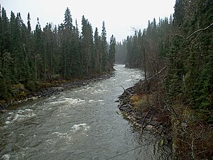
The Alberta–British Columbia foothills forests are a temperate coniferous forests ecoregion of Western Canada, as defined by the World Wildlife Fund (WWF) categorization system. This ecoregion borders Canada's taiga and contains a mix of subarctic forest and temperate forest species as a result. This makes the region an ecotone region, or a region that acts as a buffer between two other biomes.

<span class="mw-page-title-main">Eastern Canadian forests</span> Taiga ecoregion of eastern Canada

The Eastern Canadian forests is a boreal ecoregion in Eastern Canada, as defined by the World Wildlife Fund (WWF) categorization system.

<span class="mw-page-title-main">Eastern Canadian Shield taiga</span> Taiga ecoregion of Labrador and Quebec, Canada

The Eastern Canadian Shield taiga is an ecoregion of Canada as defined by the World Wildlife Fund (WWF) categorization system.

<span class="mw-page-title-main">Yukon Interior dry forests</span> Taiga ecoregion of British Columbia and Yukon, Canada

The Yukon Interior dry forests is a taiga ecoregion of Canada.

<span class="mw-page-title-main">Muskwa–Slave Lake forests</span> Taiga ecoregion of northwestern Canada

The Muskwa-Slave Lake forests ecoregion covers Canadian taiga in northwestern Alberta, northeastern British Columbia and a large portion of the southwestern Northwest Territories around the Mackenzie River valley and the Great Slave Lake.

<span class="mw-page-title-main">North Central Rockies forests</span> Temperate coniferous forest ecoregion in Canada and the United States

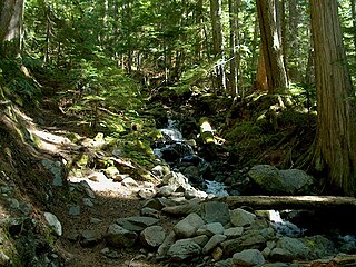
The North Central Rockies forests is a temperate coniferous forest ecoregion of Canada and the United States. This region overlaps in large part with the North American inland temperate rainforest and gets more rain on average than the South Central Rockies forests and is notable for containing the only inland populations of many species from the Pacific coast.

<span class="mw-page-title-main">Mid-Continental Canadian forests</span> Taiga ecoregion of western Canada

The Mid-Continental Canadian forests are a taiga ecoregion of Western Canada, as defined by the World Wildlife Fund (WWF) categorization system.

<span class="mw-page-title-main">Central Canadian Shield forests</span> Taiga ecoregion of Ontario and Quebec, Canada

The Central Canadian Shield forests are a taiga ecoregion of Eastern Canada, as defined by the World Wildlife Fund (WWF) categorization system.

<span class="mw-page-title-main">Western Great Lakes forests</span> Temperate broadleaf and mixed forest ecoregion in Canada and the United States

The Western Great Lakes forests is a terrestrial ecoregion as defined by the World Wildlife Fund. It is within the temperate broadleaf and mixed forests biome of North America. It is found in northern areas of the United States' states of Michigan, Wisconsin and Minnesota, and in southern areas of the Canadian province of Manitoba and northwestern areas of the province of Ontario.

<span class="mw-page-title-main">Southern Great Lakes forests</span> Temperate broadleaf and mixed forests ecoregion of Canada and the United States

The Southern Great Lakes lowland forests is a temperate broadleaf and mixed forest ecoregion of North America, as defined by the World Wildlife Fund. Located near the Great Lakes, it lies mostly in the central northeastern United States and extends into southeast central Canada. In modern times, little of it remains intact due to land use, including agriculture and urban uses.

<span class="mw-page-title-main">Southern Hudson Bay taiga</span> Taiga ecoregion of Canada

The Southern Hudson Bay taiga is a terrestrial ecoregion, as classified by the World Wildlife Fund, which extends along the southern coast of Hudson Bay and resides within the larger taiga biome. The region is nearly coterminous with the Hudson Plain, a Level I ecoregion of North America as designated by the Commission for Environmental Cooperation (CEC) in its North American Environmental Atlas.

<span class="mw-page-title-main">Northwest Territories taiga</span> Taiga ecoregion located in the Northwest Territories and Yukon provinces of Canada

The Northwest Territories taiga ecoregion (WWF:NA0614) is located in the Northwest Territories and Yukon provinces of Canada. It covers forest and tundra along the Mackenzie River Valley and the surrounding highlands in the southern portion of the valley.

<span class="mw-page-title-main">Low Arctic tundra</span> Tundra ecoregion of Canada

The Low Arctic tundra ecoregion covers a rolling landscape of shrubby tundra vegetation along the northern edge of the mainland Canada along the border of the Northwest Territories and Nunavut, and a small portion in Quebec on the northeast coast of Hudson Bay. The region is important for large herds of caribou and other large mammals, and for large nesting colonies of birds such as snow geese. The region is mostly intact, with 95% remaining intact.

References

  1. 1 2 "Midwestern Canadian Shield forests". Terrestrial Ecoregions. World Wildlife Fund.