
Canada has a vast geography that occupies much of the continent of North America, sharing a land border with the contiguous United States to the south and the U.S. state of Alaska to the northwest. Canada stretches from the Atlantic Ocean in the east to the Pacific Ocean in the west; to the north lies the Arctic Ocean. Greenland is to the northeast with a shared border on Hans Island. To the southeast Canada shares a maritime boundary with France's overseas collectivity of Saint Pierre and Miquelon, the last vestige of New France. By total area, Canada is the second-largest country in the world, after Russia. By land area alone, however, Canada ranks fourth, the difference being due to it having the world's largest proportion of fresh water lakes. Of Canada's thirteen provinces and territories, only two are landlocked while the other eleven all directly border one of three oceans.

The Canadian Shield, also called the Laurentian Plateau, is a geologic shield, a large area of exposed Precambrian igneous and high-grade metamorphic rocks. It forms the North American Craton, the ancient geologic core of the North American continent. Glaciation has left the area with only a thin layer of soil, through which exposures of igneous bedrock resulting from its long volcanic history are frequently visible. As a deep, common, joined bedrock region in eastern and central Canada, the Shield stretches north from the Great Lakes to the Arctic Ocean, covering over half of Canada and most of Greenland; it also extends south into the northern reaches of the United States.

Located in the eastern part of Canada, and part of Central Canada, Quebec occupies a territory nearly three times the size of France or Texas. It is much closer to the size of Alaska. As is the case with Alaska, most of the land in Quebec is very sparsely populated. Its topography is very different from one region to another due to the varying composition of the ground, the climate, and the proximity to water. The Great Lakes–St. Lawrence Lowlands and the Appalachians are the two main topographic regions in southern Quebec, while the Canadian Shield occupies most of central and northern Quebec.

Alberta is one of the thirteen provinces and territories of Canada. Located in Western Canada, the province has an area of 661,190 km2 (255,290 sq mi) and is bounded to the south by the United States state of Montana along 49° north for 298 km (185 mi); to the east at 110° west by the province of Saskatchewan for 1,223 km (760 mi); and at 60° north the Northwest Territories for 644 km (400 mi). The southern half of the province borders British Columbia along the Continental Divide of the Americas on the peaks of the Rocky Mountains, while the northern half borders British Columbia along the 120th meridian west. Along with Saskatchewan it is one of only two landlocked provinces or territories.

The Boreal Shield Ecozone, as defined by the Commission for Environmental Cooperation (CEC), is the largest ecozone in Canada. Covering 1.8 million square kilometres it covers almost 20% of Canada's landmass, stretching from northern Saskatchewan to Newfoundland.
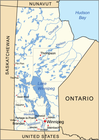
The geography of Manitoba addresses the easternmost of the three prairie Canadian provinces, located in the longitudinal centre of Canada. Manitoba borders on Saskatchewan to the west, Ontario to the east, Nunavut to the north, and the American states of North Dakota and Minnesota to the south. Although the border with Saskatchewan appears straight on large-scale maps, it actually has many right-angle corners that give the appearance of a slanted line. In elevation, Manitoba ranges from sea level on Hudson Bay to 2727 ft (831 m) on top of Baldy Mountain. The northern sixty percent of the province is on the Canadian Shield. The northernmost regions of Manitoba lie permafrost, and a section of tundra bordering Hudson Bay.
The Great Lakes-St. Lawrence Lowlands, or simply St. Lawrence Lowlands, is a physiographic region of Eastern Canada that comprises a section of southern Ontario bounded on the north by the Canadian Shield and by three of the Great Lakes — Lake Huron, Lake Erie and Lake Ontario — and extends along the St. Lawrence River to the Strait of Belle Isle and the Atlantic Ocean. The lowlands comprise three sub-regions that were created by intrusions from adjacent physiographic regions — the West Lowland, Central Lowland and East Lowland. The West Lowland includes the Niagara Escarpment, extending from the Niagara River to the Bruce Peninsula and Manitoulin Island. The Central Lowland stretches between the Ottawa River and the St. Lawrence River. The East Lowland includes Anticosti Island, Îles de Mingan, and extends to the Strait of Belle Isle.

The Arctic Archipelago Marine Ecozone, as defined by the Commission for Environmental Cooperation (CEC), is a marine ecozone in the Canadian Arctic, encompassing Hudson Bay, James Bay, the internal waters and some shores of the islands in the Canadian Arctic Archipelago, and the shores of the territories, northern Ontario and western Quebec. Early exploration of these waters by Europeans were conducted to find a passage to the Orient, now referred to as the Northwest Passage.
The Atlantic Maritime Ecozone, as defined by the Commission for Environmental Cooperation (CEC), is an ecozone which covers the Canadian provinces of Prince Edward Island, Nova Scotia, and New Brunswick, as well as the Gaspé Peninsula of Quebec. It is adjacent to the Atlantic Marine Ecozone to the east, and the Mixedwood Plains to the west. The roughly-corresponding Level I Ecoregion to this ecozone in the United States Environmental Protection Agency's classification, which is also part of the CEC system, is the Northern Forests ecoregion, though that classification includes the woodlands and swamps of northern Michigan and Minnesota, which are adjacent to the Boreal Shield ecozone.

The Boreal Plains Ecozone, as defined by the Commission for Environmental Cooperation (CEC), is a terrestrial ecozone in the western Canadian provinces of Manitoba, Saskatchewan and Alberta. It also has minor extensions into northeastern British Columbia and south-central Northwest Territories. The region extends over 779,471 km2, of which 58,981 km2 is conserved.
The Taiga Plain Ecozone, as defined by the Commission for Environmental Cooperation (CEC), is a Canadian terrestrial ecozone that covers most of the western Northwest Territories, extending to northwest Alberta, northeast British Columbia and slightly overlapping northeastern Yukon.

The Boreal Cordillera Ecozone, as defined by the Commission for Environmental Cooperation (CEC), is a Canadian terrestrial ecozone occupying most of the northern third of British Columbia and southern half of Yukon. Within it is found Kluane National Park and Reserve, and a small portion of the southern range of Nahanni National Park Reserve. Most of the area's population is based in the city of Whitehorse, and it contains most of Yukon's population. The portion in British Columbia is barely populated.

The Southern Arctic Ecozone, as defined by the Commission for Environmental Cooperation (CEC), is a Canadian terrestrial ecozone which spans the northern coast of mainland Northwest Territories, most of northern mainland Nunavut excepting the northeast peninsula, and a portion of northwestern Quebec. Its two constituent territories are interrupted by Hudson Bay. The ecozone can also be described as including the northernmost part of the Interior Plains of Western Canada and parts of the Canadian Shield located on both sides of northern Hudson Bay.

Canada's boreal forest is a vast region comprising about one third of the circumpolar boreal forest that rings the Northern Hemisphere, mostly north of the 50th parallel. Other countries with boreal forest include Russia, which contains the majority; the United States in its northernmost state of Alaska; and the Scandinavian or Northern European countries. In Europe, the entire boreal forest is referred to as taiga, not just the northern fringe where it thins out near the tree line. The boreal region in Canada covers almost 60% of the country's land area. The Canadian boreal region spans the landscape from the most easterly part of the province of Newfoundland and Labrador to the border between the far northern Yukon and Alaska. The area is dominated by coniferous forests, particularly spruce, interspersed with vast wetlands, mostly bogs and fens. The boreal region of Canada includes eight ecozones. While the biodiversity of regions varies, each ecozone has a characteristic native flora and fauna.

The native flora of Saskatchewan includes vascular plants, plus additional species of other plants and plant-like organisms such as algae, lichens and other fungi, and mosses. Non-native species of plants are recorded as established outside of cultivation in Saskatchewan, of these some non-native species remain beneficial for gardening, and agriculture, where others have become invasive, noxious weeds. Saskatchewan is committed to protecting species at risk in Canada. The growing season has been studied and classified into plant hardiness zones depending on length of growing season and climatic conditions. Biogeographic factors have also been divided into vegetative zones, floristic kingdoms, hardiness zones and ecoregions across Saskatchewan, and natural vegetation varies depending on elevation, moisture, soil type landforms, and weather. The study of ethnobotany uncovers the interrelation between humans and plants and the various ways people have used plants for economic reasons, food, medicine and technological developments. The Government of Saskatchewan has declared 3 indigenous plants as provincial symbols.

The Fauna of Saskatchewan include several diverse land and aquatic animal species. From the multiplicity of invertebrates and vertebrates, two have been chosen as symbols of Saskatchewan. Cenozoic vertebrate fossils reveal the geological evolution of the interior plains and its prehistoric biogeography. Today, Saskatchewan's ecosystems range from the sub-arctic tundra of the Canadian Shield in north Saskatchewan to aspen parkland, the Mid-Continental Canadian forests in the centre of the province and grassland prairie. Fauna inhabit areas unique to their own specific and varied breeding, foraging and nesting requirements. With a large land and water area, and small population density, the ecoregions of Saskatchewan provide important habitat for many animals, both endangered and not. Naturalists observing wildlife have enumerated shrinking and growing wildlife populations. They advocate programs and methods to preserve or re-introduce endangered species and identify programs of control for outbreaks of wildlife populations. A broad diversity of wildlife habitats are preserved as parks and reserves protecting the feeding and breeding grounds of protected and indigenous fauna of Saskatchewan.
Northern Canadian Shield taiga is a taiga ecoregion located in northern Canada, stretching from Great Bear Lake in the Northwest Territories to Hudson Bay in eastern Nunavut. The region supports conifer forests to its northern edge, where the territory grades into tundra. The open forest in this transition zone is characterized by widely scattered, stunted stands of black spruce and tamarack, with some white spruce. The ecoregion lies over the northwestern extent of the Canadian Shield.

The Southern Hudson Bay taiga is a terrestrial ecoregion, as classified by the World Wildlife Fund, which extends along the southern coast of Hudson Bay and resides within the larger taiga biome. The region is nearly coterminous with the Hudson Plain, a Level I ecoregion of North America as designated by the Commission for Environmental Cooperation (CEC) in its North American Environmental Atlas.
