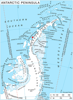
Bertram Glacier is a glacier, 15 nautical miles (28 km) long and 18 nautical miles (33 km) wide at its mouth, which flows west from the Dyer Plateau of Palmer Land into George VI Sound between Wade Point and Gurney Point.

The Boker Rocks are a rocky exposure located 5 nautical miles (9 km) northeast of Von der Wall Point on the south coast of Thurston Island. The feature was mapped by the United States Geological Survey from surveys and from U.S. Navy air photos, 1960–66, and named by the Advisory Committee on Antarctic Names for Helmut C. Boker, a meteorologist at Byrd Station, 1964–65.
The Bragg Islands are a small group of islands in Crystal Sound, about 7 nautical miles (13 km) north of Cape Rey, Graham Land. They were mapped from surveys by the Falkland Islands Dependencies Survey (1958–59) and from air photos obtained by the Ronne Antarctic Research Expedition (1947–48). The group was named by the UK Antarctic Place-Names Committee for Sir William H. Bragg, an English physicist who interpreted X-ray measurements to give the location of oxygen atoms in the structure of ice.
Cavalier Rock is an isolated rock lying 13 nautical miles (24 km) southwest of Cape Adriasola, off the south part of Adelaide Island. It was named by the UK Antarctic Place-Names Committee in 1963 for Sub. Lieutenant Geoffrey A. Cavalier, Royal Navy, helicopter pilot of HMS Protector who flew the reconnaissances which located this feature.

Conway Island lies in Crates Bay to the west of Lens Peak and facing Bregare Point, off the northeast coast of Stresher Peninsula, Graham Land. It was photographed by Hunting Aerosurveys Ltd in 1956–57, and mapped from these photos by the Falkland Islands Dependencies Survey. It was named by the UK Antarctic Place-Names Committee in 1959 for Martin Conway, 1st Baron Conway of Allington, an English mountaineer and a pioneer of polar skiing during his crossing of Vestspitsbergen in 1896.
طNye Glacier is a glacier on Arrowsmith Peninsula flowing southwest to Whistling Bay, in Graham Land. Mapped by Falkland Islands Dependencies Survey (FIDS) from surveys and air photos, 1948-59. It was named by the United Kingdom Antarctic Place-Names Committee (UK-APC) for John F. Nye, an English physicist who has made theoretical contributions to the study of the flow of glaciers and ice sheets.
Davis Valley is an ice-free valley just east of Forlidas Ridge in north-east Dufek Massif, in the Pensacola Mountains of Queen Elizabeth Land, Antarctica. It was mapped by the United States Geological Survey from surveys and U.S. Navy air photos in 1956–66, and was named by the Advisory Committee on Antarctic Names for Edward H. Davis, a construction mechanic with the Ellsworth Station winter party, 1957.
Elliott Passage is a marine channel running northeast–southwest between the southeast coast of Adelaide Island and Jenny Island. It was named by the UK Antarctic Place-Names Committee in 1984 after Captain Christopher R. Elliott, Master of the RRS John Biscoe from 1975, having also served in other officer positions on the John Biscoe and the RRS Bransfield from 1967.
Friederichsen Glacier is a glacier 7 nautical miles (13 km) long, which flows in an easterly direction into Cabinet Inlet, close north of Mount Hulth, on the east coast of Graham Land, Antarctica. It was charted by the Falkland Islands Dependencies Survey (FIDS) and photographed from the air by the Ronne Antarctic Research Expedition in 1947. It was named by the FIDS for Ludwig Friederichsen, a German cartographer who in 1895 published a chart based upon all existing explorations of the Antarctic Peninsula and the South Shetland Islands.
Gibbs Glacier is a glacier, 15 nautical miles (28 km) long, flowing southeast into the northern part of Mercator Ice Piedmont on the east side of the Antarctic Peninsula. This feature together with Neny Glacier, which flows northwest, occupy a transverse depression between Mercator Ice Piedmont and Neny Fjord on the west side of the Antarctic Peninsula. Gibbs Glacier was photographed from the air and first mapped by the United States Antarctic Service, 1939–41, and the Ronne Antarctic Research Expedition, 1947–48. It was named by the UK Antarctic Place-Names Committee for Peter M. Gibbs of the Falkland Islands Dependencies Survey, a surveyor at Horseshoe Island, 1957, and leader at Stonington Island, 1958, who was responsible for the first ground survey of the glacier.
Mosby Glacier is a glacier 5 nautical miles (9 km) wide at its mouth, flowing in a southeasterly direction to the northwest corner of New Bedford Inlet, on the east coast of Palmer Land, Antarctica. It was discovered and photographed from the air in December 1940 by the United States Antarctic Service. During 1947 it was photographed from the air by the Ronne Antarctic Research Expedition under Finn Ronne, who in conjunction with the Falkland Islands Dependencies Survey (FIDS) mapped its terminus from the ground. It was named by the FIDS for Hakon Mosby, a Norwegian meteorologist and oceanographer.
Merrick Point is an ice-covered point on the east side of Hamilton Ice Piedmont, Bear Peninsula, on the Walgreen Coast of Marie Byrd Land, Antarctica. It was mapped by the United States Geological Survey from surveys and U.S. Navy aerial photographs, 1959–66, and was named by the Advisory Committee on Antarctic Names in 1977 after Dale Merrick of Stanford University, upper atmosphere researcher and Station Scientific Leader at Siple Station, winter party 1975.
Longton Point is a feature of sheer high rock cliffs alternating with steep icefalls, forming the southeast corner of Cook Island in the South Sandwich Islands. It was named by the UK Antarctic Place-Names Committee for Royce E. Longton, botanist of the survey of the South Sandwich Islands from HMS Protector in 1964.

McManus Glacier is a glacier flowing north into Palestrina Glacier, in northwestern Alexander Island, Antarctica. It separates Lassus Mountains on the west from Sofia University Mountains on the east. The glacier was surveyed by the British Antarctic Survey (BAS), 1975–76, and was named by the UK Antarctic Place-Names Committee in 1980 after Alan James McManus, a BAS cook at Grytviken and Faraday Research Station, 1971–73, and at Adelaide Island and Rothera Research Station, 1975–78.
Heim Glacier is a glacier 8 nautical miles (15 km) long in the southeast part of Arrowsmith Peninsula, which flows south to merge with the ice in Jones Channel on the west coast of Graham Land, Antarctica. With Antevs Glacier to the north, it forms a transverse depression extending to the southwest part of Lallemand Fjord. Heim Glacier was first sighted from the air in 1936 by the British Graham Land Expedition under John Rymill. Its lower reaches were surveyed in 1949 by the Falkland Islands Dependencies Survey, and the glacier named by them for Albert Heim, a Swiss glaciologist and the author in 1885 of Handbuch der Gletscherkunde.

Savage Glacier is a glacier at the east end of Thurston Island, lying south of Tierney Peninsula and flowing east to Seraph Bay. The glacier was discovered on helicopter flights from the USS Glacier and Burton Island by personnel of the U.S. Navy Bellingshausen Sea Expedition in February 1960. The Advisory Committee on Antarctic Names named the glacier for Lieutenant John Savage, U.S. Navy, dental officer aboard the Glacier, who assisted in establishing geodetic control points in the area.
Mount Holdgate is a prominent mountain, 960 metres (3,150 ft) high, with steep icefalls and rock buttresses which provides a clear landmark at the southeast end of Cook Island in the South Sandwich Islands. It was named by the UK Antarctic Place-Names Committee for Martin W. Holdgate, organizer and senior scientist of the survey of the South Sandwich Islands from HMS Protector in 1964.
Horrall Glacier is a tributary glacier in the Kohler Range of Marie Byrd Land, Antarctica. It flows east-northeast from Faulkender Ridge to join Kohler Glacier at Klimov Bluff. The glacier was mapped by the United States Geological Survey from surveys and U.S. Navy air photos, 1959–65, and was named by the Advisory Committee on Antarctic Names for Thomas R. Horrall, a United States Antarctic Research Program glaciologist with the Marie Byrd Land Survey party, 1966–67.
Ramsey Cliff is a rock cliff along Torbert Escarpment, standing 2 nautical miles (3.7 km) northeast of Mount Torbert in the Neptune Range, Pensacola Mountains. Mapped by United States Geological Survey (USGS) from surveys and U.S. Navy air photos, 1956-66. Named by Advisory Committee on Antarctic Names (US-ACAN) for Robert E. Ramsey, storekeeper at Ellsworth Station, winter 1958.
Rossini Point is a snow-covered point on the south coast of Alexander Island, Antarctica. This headland marks the southeast side of the entrance to the embayment occupied by Bach Ice Shelf. First seen and roughly mapped by the United States Antarctic Service (USAS), 1939-41. Remapped in greater detail from air photos obtained by the Ronne Antarctic Research Expedition (RARE), 1947–48, by Searle of the Falkland Islands Dependencies Survey (FIDS) in 1960. Named by the United Kingdom Antarctic Place-Names Committee (UK-APC) for Gioacchino Rossini (1792–1868), Italian composer.


