Related Research Articles

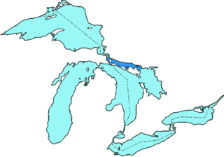
The Great Lakes, also called the Great Lakes of North America, are a series of large interconnected freshwater lakes spanning the Canada–United States border. The five lakes are Superior, Michigan, Huron, Erie, and Ontario. The Great Lakes Waterway enables modern travel and shipping by water among the lakes. The lakes connect to the Atlantic Ocean via the Saint Lawrence River, and to the Mississippi River basin through the Illinois Waterway.

Lake Michigan is one of the five Great Lakes of North America. It is the second-largest of the Great Lakes by volume and the third-largest by surface area, after Lake Superior and Lake Huron. To the east, its basin is conjoined with that of Lake Huron through the wide and deep Straits of Mackinac, giving it the same surface elevation as its easterly counterpart; geologically, the two bodies are a single lake that is, by area, the largest freshwater lake in the world.

Lake Huron is one of the five Great Lakes of North America. It is shared on the north and east by the Canadian province of Ontario and on the south and west by the U.S. state of Michigan. The name of the lake is derived from early French explorers who named it for the indigenous people they knew as Huron (Wyandot) inhabiting the region. Hydrologically, Lake Huron comprises the eastern portion of Lake Michigan–Huron, having the same surface elevation as Lake Michigan, to which it is connected by the 5-mile-wide (8.0 km), 20-fathom-deep Straits of Mackinac. Combined, Lake Michigan–Huron is the largest freshwater lake by area in the world. The Huronian glaciation was named from evidence collected from Lake Huron region. The northern parts of the lake include the North Channel and Georgian Bay. Saginaw Bay is located in the southwest corner of the lake. The main inlet is the St. Marys River from Lake Superior, and the main outlet is through the St. Clair River toward Lake Erie. Lake Huron has a fairly large drainage basin covering parts of Michigan and Ontario. Water flows through Lake Huron faster than the other Great Lakes with a retention time of only 22 years.
Lake Simcoe is a lake in southern Ontario, Canada, the fourth-largest lake wholly in the province, after Lake Nipigon, Lac Seul, and Lake Nipissing. At the time of the first European contact in the 17th century, the lake was called Ouentironk by the native Wendat/Ouendat (Huron) people. It was also known as Lake Taronto until it was renamed by John Graves Simcoe, the first Lieutenant-Governor of Upper Canada, in memory of his father, Captain John Simcoe of the Royal Navy. In Anishinaabemowin, the historical language of the First Nations living around this lake, namely Anishinaabek of Rama and Georgina Island First Nations, the lake is called Zhooniyaang-zaaga'igan, meaning "Silver Lake".

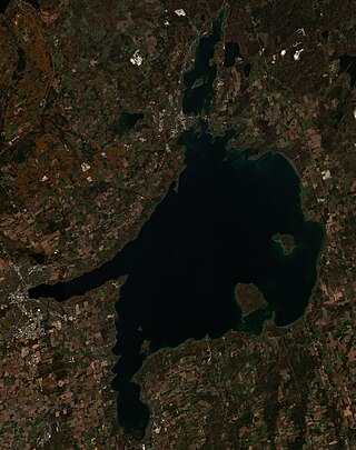
Georgian Bay is a large bay of Lake Huron, in the Laurentia bioregion. It is located entirely within the borders of Ontario, Canada. The main body of the bay lies east of the Bruce Peninsula and Manitoulin Island. To its northwest is the North Channel.

Vega Island is an island in Antarctica, 17 nautical miles long and 6 nautical miles wide, which is the northernmost of the James Ross Island group and lies in the west part of Erebus and Terror Gulf. It is separated from James Ross Island by Herbert Sound and from Trinity Peninsula by Prince Gustav Channel.

Rongé Island is a high, rugged island 5 nautical miles long, the largest island of the group which forms the west side of Errera Channel, off the west coast of Graham Land in Antarctica.

Galindez Island is an island 0.5 nautical miles long, lying immediately east of Winter Island in the Argentine Islands, Wilhelm Archipelago, Antarctica. It is home to the Vernadsky Research Base.
The North Channel is the body of water along the north shore of Lake Huron, in the Canadian province of Ontario and the state of Michigan in the United States of America. It stretches approximately 160 nautical miles (300 km) and is bordered on the east by Georgian Bay, on the west by the St. Marys River, to the north by the eastern Algoma District and part of the Sudbury District, and to the south by the islands of Manitoulin, Cockburn, Drummond and St. Joseph. At its widest point it is over 30 km wide.

Lake Kagawong is the second largest lake on Manitoulin Island in Ontario, Canada. Located in the central part of the island, the lake is drained by the Kagawong River, which falls over Bridal Veil Falls into Lake Huron. Kagawong means "[where mists rise] from the falling [waters]" in the local Ojibwe language.

Seymour Island or Marambio Island, is an island in the chain of 16 major islands around the tip of the Graham Land on the Antarctic Peninsula. Graham Land is the closest part of Antarctica to South America. It lies within the section of the island chain that resides off the west side of the peninsula's northernmost tip. Within that section, it is separated from Snow Hill Island by Picnic Passage, and sits just east of the larger key, James Ross Island, and its smaller, neighboring island, Vega Island.

Vivonne Bay is a bay in the Australian state of South Australia located on the south coast of Kangaroo Island about 61 kilometres (38 mi) from Kingscote, the island's main town, and which was named by the members of Baudin expedition to Australia who visited the bay in January 1803. In a survey of 10,000 beaches by Professor Andrew Short, director of Sydney University's marine studies centre, the beach at Vivonne Bay was adjudged as one of the best in Australia.

Georgina Island is the largest of the lake islands of Lake Simcoe, located in southern Ontario, Canada. The island is a Native reserve populated by the Chippewas of Georgina Island First Nation, a band of Ojibwa people. It is also within the Town of Georgina and in the Regional Municipality of York.
Skua Island is a roughly triangular island 0.7 nautical miles long, lying between Black Island to the southwest and Winter Island and Galindez Island to the north and northeast, in the Argentine Islands, Wilhelm Archipelago.

The Quiniluban Group is a group of islands in Palawan Province of the Philippines situated between the islands of Palawan and Panay in the Sulu Sea. The group is the northernmost in the Cuyo Archipelago, consisting of several islands and rocks. The easternmost of which is a circular group of islands surrounded by reef about 6 nautical miles in diameter. The largest of the circular group is Quiniluban Island. The island group also includes the upscale resort island of Pamican located about 5.6 nautical miles southwest of the circular group, and Manamoc Island located 3.0 nautical miles further southwest of Pamilacan.
Bryde Island is an island 6 nautical miles long and 3 nautical miles wide, lying immediately southwest of Lemaire Island, off the west coast of Graham Land, Antarctica.

The Skate of Marrister is a flat ledge that extends about 300 yards (270 m) from the western shore of Whalsay, in the Shetland islands of Scotland. It is slightly more than 1 mile (1.6 km) north-north-west from Symbister Ness off the village of Marrister, in Linga Sound. At low tide the ledge rises 5 feet (1.5 m) above the water. There is a risk that the strong tide in Whalsay Sound will carry a boat onto the Skate. There is a minor light on the Skate with a nominal range of four miles, flashing green every six seconds.
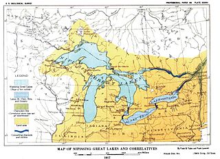
Nipissing Great Lakes was a prehistoric proglacial lake. Parts of the former lake are now Lake Superior, Lake Huron, Georgian Bay and Lake Michigan. It formed about 7,500 years before present (YBP). The lake occupied the depression left by the Labradorian Glacier. This body of water drained eastward from Georgian Bay to the Ottawa valley. This was a period of isostatic rebound raising the outlet over time, until it opened the outlet through the St. Clair valley, at one stage it had two stable outlets both draining to the east.
Busby Islet is an islet in the Australian state of South Australia located in Nepean Bay on the north coast of Kangaroo Island about 2 kilometres north of the municipal seat of Kingscote. The islet and adjoining areas are notable as habitat for bird life. The islet has enjoyed protected area status since 1909 and since at least 1972, have been part of the Busby Islet Conservation Park.

Black River Island is an island in Lake Huron. It is part of a series of shoals around the mouth of Black River and is 3⁄4 mile (1.2 km) northeast of it. The island is included within the unincorporated community of Black River in Alcona Township, Michigan.
References
- ↑ Google Maps , retrieved December 22, 2014
- 1 2 3 Canadian Hydrographic Service (1977), Sailing Directions: Great Lakes, Volume 2, p. 153, retrieved December 22, 2014
- ↑ The Atlas of Canada - Toporama , retrieved December 22, 2014
- 1 2 3 United States Hydrographic Office, Sailing Directions for North Channel of Lake Huron and Georgian Bay , retrieved December 22, 2014