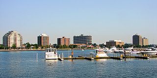
Sarnia is a city in Lambton County, Ontario, Canada. It had a 2021 population of 72,047, and is the largest city on Lake Huron. Sarnia is located on the eastern bank of the junction between the Upper and Lower Great Lakes, where Lake Huron flows into the St. Clair River in the Southwestern Ontario region, which forms the Canada–United States border, directly across from Port Huron, Michigan.

Dryden is the second-largest city in the Kenora District of northwestern Ontario, Canada, located on Wabigoon Lake. It is the least populous community in Ontario incorporated as a city. The City of Dryden had a population of 7,388 and its population centre had a population of 5,355 in 2021.

In Canada, an Indian reserve or First Nations reserve is defined by the Indian Act as a "tract of land, the legal title to which is vested in Her Majesty, that has been set apart by Her Majesty for the use and benefit of a band." Reserves are areas set aside for First Nations, one of the major groupings of Indigenous peoples in Canada, after a contract with the Canadian state, and are not to be confused with Indigenous peoples' claims to ancestral lands under Aboriginal title.

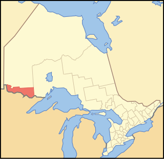
Lambton County is a county in Southwestern Ontario, Canada. It is bordered on the north by Lake Huron, which is drained by the St. Clair River, the county's western border and part of the Canada-United States border. To the south is Lake Saint Clair and Chatham-Kent. Lambton County's northeastern border follows the Ausable River and Parkhill Creek north until it reaches Lake Huron at the beach community of Grand Bend. The county seat is in the Town of Plympton-Wyoming.
Rainy River District is a district and census division in Northwestern Ontario in the Canadian province of Ontario. It was created in 1885. It is the only division in Ontario that lies completely in the Central Time Zone, except for the township of Atikokan observing Eastern Standard Time for part of the year. Its seat is Fort Frances. It is known for its fishing and its location on the US border opposite International Falls, Minnesota, and Baudette, Minnesota.

Kettle & Stony Point First Nation comprises the Kettle Point reserve and Stony Point Reserve, both located approximately 35 kilometres (22 mi) northeast of Sarnia, Ontario, Canada, on the southern shore of Lake Huron. The reserves serve as the land base for the Chippewas (Anishnaabeg) of Kettle and Stony Point First Nation.

The Magnetawan First Nation is an Ojibwe First Nation community in Ontario, Canada. The community is situated on reserve lands in Britt, Ontario.
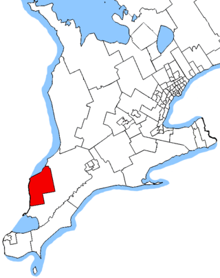
Sarnia—Lambton is a federal electoral district in Ontario, Canada, that has been represented in the House of Commons of Canada since 1968. It is located in the area of the city of Sarnia, in the southwest corner of the province of Ontario.
Neskantaga First Nation is a remote Ojibway First Nation band government in the northern reaches of the Canadian province of Ontario, situated along the shore of Attawapiskat Lake in the District of Kenora.
Asubpeeschoseewagong First Nation is an Ojibwe First Nations band government who inhabit northern Kenora in Ontario, Canada. Their landbase is the 4,145 ha English River 21 Indian Reserve. It has a registered population of 1,595 as of October 2019, of which the on-reserve population was 971. As of October 2023, the community had a registered population of 1,608. They are a signatory to Treaty 3.

Zhiibaahaasing First Nation is a First Nation band government in the Canadian province of Ontario. It is a member of the United Chiefs and Councils of Manitoulin.
Cat Lake First Nation is an Ojibway First Nation reserve approximately 180 kilometres northwest of Sioux Lookout in northwestern Ontario, Canada, located on the central north shore of Cat Lake. As of 2021, their total registered population was 651 people.
Ontario Minamata disease is a neurological syndrome caused by severe mercury poisoning. It occurred in the Canadian province of Ontario, in 1970, and severely affected two First Nation communities in Northwestern Ontario following consumption of local fish contaminated with mercury, and one First Nation in Southern Ontario due to illegal disposal of industrial chemical waste. The disease was named after the infamous case of severe mercury poisoning in the fishing community of Minamata, Japan, which became known as Minamata disease because it devastated only the residents of the community.
Poplar Hill First Nation is an Anishinaabe (Ojibway) First Nation band government, approximately 120 km north of Red Lake near the Ontario-Manitoba border. The First Nation is accessible by air and winter road. In May 2016, the First Nation had a registered population of 473 people.

Fort William First Nation is an Ojibwa First Nation reserve in Ontario, Canada. The administrative headquarters for this band government is south of Thunder Bay. As of January 2008, the First Nation had a registered population of 1,798 people, of which their on-Reserve population was 832 people.
Gakijiwanong Anishinaabe Nation is a Saulteaux First Nation band government who reside in the Rainy River District of northwestern Ontario, Canada, along the Ontario-Minnesota border. It is approximately 200 km northwest of Thunder Bay, Ontario. As of January 2008, the First Nation had a registered population of 398 people, of which their on-Reserve population was 273.

The Sagamok Anishnawbek First Nation, also known as Many Rivers Joining-Human Beings, is a First Nations band government located in Ontario, Canada. Sagamok's culture and language is Anishinabek and is made up of the Ojibwe, Odawa and Pottawatomi bands. The Sagamok occupy the Sagamok reserve approximately 120 kilometres west of Sudbury, Ontario, and have a population of approximately 1650.

Sarnia's "Chemical Valley" and the surrounding area are home to 62 chemical facilities and refineries. A 2007 Ecojustice Canada report showed that industrial facilities located within 25km of Sarnia, Ontario emitted more than 131,000 tonnes of air pollution in 2005.

Corunna is an unincorporated community in St. Clair Township, Lambton County, Ontario, Canada. The site of the community was surveyed by William Beresford in 1823. The community is located approximately 13 kilometres (8.1 mi) south of Sarnia. The community experienced a significant population boom between the 1830s and 1850s, mainly attributed to Scotch-Irish immigration. The community serves as the location of Chemical Valley, a major petrochemical and plastics manufacturing facility.
Miss Indigenous Canada is a national beauty pageant in Canada exclusively for women of Indigenous Canadian background. Women of First Nations, Inuit and Métis background represent their communities in a competition which focuses on their character, community service, cultural involvement, and ambassadorship for their communities.

