Bala, Ontario

Last updated

Bala
Compact rural community
Bala Bay.jpg
The southern portion of the town as viewed from Bala Bay; the KEE to Bala is visible at right
Etymology: Named for Bala, Wales
Nickname: 
Cranberry Capital of Ontario [1]
Canada Southern Ontario location map 2.png
Red pog.svg
Bala
Location in Southern Ontario
Coordinates: 45°01′03″N79°37′02″W / 45.0175°N 79.6172°W / 45.0175; -79.6172 [2]
Country Canada
Province Ontario
District Muskoka
Township Municipality Muskoka Lakes
Established1868 (1868)
Incorporated (town)1914
Amalgamated1971
Founded by Thomas Burgess
Elevation
[3]
232 m (761 ft)
Time zone UTC-5 (Eastern Time Zone)
  Summer (DST) UTC-4 (Eastern Time Zone)
Postal code
P0C 1A0
Area codes 705, 249

Bala is a compact rural community [2] in the township municipality of Muskoka Lakes, District Municipality of Muskoka in Central Ontario, Canada. [2] [4] [5] [6] [7] It is well-known for the Bala Falls, the source of the Moon River, which flows from Lake Muskoka to the Georgian Bay.

Contents

It is considered one of the hubs of cottage country located north of Toronto. Thus, its year-round population of several hundred is increased by thousands of seasonal residents and weekend day-trippers during summer months. It is known as the Cranberry Capital of Ontario, as the province's largest cranberry farms, Muskoka Lakes Farm and Winery (formerly Johnston's Cranberry Marsh) and the former Iroquois Cranberry Growers (closed in 2017), are located nearby. It was once the smallest incorporated town in Canada until it was amalgamated into Muskoka Lakes Township.

History

Bala was settled by Thomas Burgess in 1868. Thomas Burgess opened a sawmill and store to serve the area's scattered settlers. [8] [9] Thomas Burgess named it after the town of Bala in Wales with which it is officially twinned. [8] [9] Located on the Canadian Shield, it proved unsuitable for farming, and its fortunes declined as logging became less economically viable. Railway connections helped to re-establish the village as a popular location for summer resorts. [8] [9]

In 1914, the town incorporated with Burgess's son as the first mayor, making it the smallest incorporated town in Canada. [8] [9]

Geography

South Falls Bala ON 2.JPG
South Falls

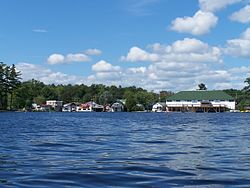
Located at the west end of Lake Muskoka, at the foot of Bala Bay, the prominent geographical feature of the town are the many bare outcroppings of the Canadian Shield. Carved out of the Shield is Bala Falls, the only outlet for Lake Muskoka. That allows water to empty from the Muskoka River watershed into the Moon River and eventually Georgian Bay; however, the falls were at a low elevation and for many years the water levels of Lake Muskoka were known to fluctuate eight or nine feet every season, between the spring runoffs and the late fall. That led to many navigation problems both for the timber industry and the settlers. In 1873, a control dam was built at the Bala Falls, which still exists in an upgraded form and is known as the North Falls. However, the dam worked too well and led to flooding, which forced the construction soon after of a large flood control dam and channel, known today as the South Falls. [10]

A further channel north of the North Falls was created in the 1880s to power a sawmill and later reused as the water intake channel for a hydroelectric station built in 1917. The station, operated by the Bala Electric Light and Power Company to supply electricity as far as MacTier and Port Carling was retired in 1957 but then returned to active use as a small remotely-operated station in the 1990s. It remains in use today.

A second station operated between the North and South Falls from 1924 to 1957 but was later demolished because it was uneconomical. A new generating station is being built at the site, [11] a project that caused much local controversy. [12]

Transportation

CPR station circa 1910 CPR station, Bala, Muskoka Lakes, Canada, Micklethwaite.jpg
CPR station circa 1910

Bala was well connected and once was connected only to other Muskoka communities via the steamship lines that plied the Muskoka Lakes. The Cherokee, Islander and Segwun were frequently seen at the dock below the CPR station, and the Ahmic was based on the other side of Bala Bay in Torrance. Steamships have been unable to visit Bala since 1964, when the swing bridge at Bala Park Island was sealed shut. A portion of the former steamer dock remains, maintained for many decades by the MNR and today by the Township of Muskoka Lakes.

In 1907 the Canadian Pacific Railway opened a prominent "summer" station at the harbour, complete with freight elevator (a "winter" station was located a half-mile north). There was also a seasonal Grand Trunk Railway (later CN) station across the bay on Bala Park Island. In 1927, six CPR train routes each way served Bala, four on a daily basis. With the influx of many American cottagers, Bala even became a Customs Port of Entry. The Bala Weekend trains continued to serve the tourists until 1963, when the station was demolished. [13]

The settlement-era Musquosh Road from Gravenhurst arrived in the 1880s and fed further development after the heyday of the railways as the route was eventually upgraded from a rough trail into first the Rama Road, then the provincial Highway 69 (later renumbered to Highway 169, then to Muskoka Road 169). A postwar bypass was created for the highway to avoid the original Musquosh Road bridge and single-lane rail underpass at the South Falls, but that also had the effect of removing traffic from Bala's former main street south of the Falls, severely impacting businesses on that section and concentrating commercial activity along the highway north of the Falls.

Services

In 1971, the town was amalgamated with other townships and municipalities to form the Township of Muskoka Lakes; the Chamber of Commerce office is in Bala; other civic functions are located in Port Carling.

Bala was the location of the first detachment of Ontario Provincial Police in 1921. A small modern station remains just north of the main part of town (run by the Bracebridge detachment part-time). The Canada Post Post Office has been relocated to share space with the police station.

Accommodations

Until changes in transportation and development led to most seasonal visitors staying in private cottages, Bala offered summer lodging at a large number of tourist resorts over the decades. For example, Windsor Park is on the site of the former Windsor Hotel. Located on River Street were Bala Cozy Cabins and Roselawn Lodge. The Bala Bay Inn (formerly the Swastika Inn until a postwar name change) remained as an active hotel until 2016. Built in 1910, it is Muskoka's oldest brick hotel. The original tin ceiling and mahogany staircase still grace the front lobby.

Culture and entertainment

Bridge over the South Falls Bala ON 1.JPG
Bridge over the South Falls

Since 1942, under various management and names, the community and the surrounding area was offered live musical entertainment. In the 1940s and '50s, Big Bands like Mart Kenney, Cab Calloway, Tommy Dorsey, Jimmy Dorsey, Glenn Miller, Duke Ellington, Count Basie, Woody Herman and Louis Armstrong played at Dunn's Pavilion. Since the 1960s, rock musicians like David Wilcox, Kim Mitchell, The Ramones, April Wine, Burton Cummings and Jeff Healey played at The KEE to Bala. More recently, bands such as Metric, Sum 41, The Tragically Hip, The Sam Roberts Band, Hinder, Finger Eleven, Three Days Grace, Sloan, Tim Hicks, Hedley and Theory of a Deadman have graced the stage at The KEE to Bala. In the 1980s, Bala and Port Carling were also featured in a skit by The Frantics on Boot to the Head. In the skit, a man on his way to Bala bores his companion to distraction in part by endlessly enumerating the communities' features. [14] Most recently Bala is home to The New Actor's Colony professional Theatre company who perform seasonally in the summer in the local curling rink.

Lucy Maud Montgomery, author of the Anne of Green Gables books, visited Bala in 1922. The area made a sufficient impression on her that she based the novel The Blue Castle on the area, her only novel not set in Prince Edward Island. Based on the connection to a beloved Canadian author, Bala's Museum, a privately run museum featuring Montgomery, was opened in the 1990s.

Bala hosts the Bala Cranberry Festival annually on the weekend after Canadian Thanksgiving, attracting thousands of people to the town. [15]

Bala is home to Muskoka Lakes Winery, the Muskoka region's only winery, which specializes in cranberry and other fruit wines.

Once a week in the summer months, students from a nearby water ski school perform aquatic stunts for audiences at a local park. Students form pyramids, jump obstacles, ski barefoot, and occasionally ski while they wear alpine skis.

Bala Bay remains a sailing hotspot in Muskoka due to its excellent and consistent winds. A local sailing club organizes Saturday races.

See also

Related Research Articles

<span class="mw-page-title-main">Huntsville, Ontario</span> Town in Muskoka, Canada

Huntsville is a town in Muskoka. It is located 215 kilometres (134 mi) north of Toronto and 130 kilometres (81 mi) south of North Bay. Of the three big Muskoka towns, it is the largest by population and land area (710.64 km2).

<span class="mw-page-title-main">Bracebridge, Ontario</span> Town in Ontario, Canada

Bracebridge is a town and the seat of the Muskoka District Municipality in Ontario, Canada.

<span class="mw-page-title-main">Gravenhurst, Ontario</span> Town in Ontario, Canada

Gravenhurst is a town in the Muskoka Region of Ontario, Canada. It is located approximately 15 kilometres (9.3 mi) south of Bracebridge, Ontario. The Town of Gravenhurst includes a large area of the District of Muskoka, known to Ontarians as "cottage country." The town centre borders on two lakes: Lake Muskoka, which is the largest lake in the region, and Gull Lake, a smaller cottage-bordered lake. Another lake, Kahshe Lake, is situated 10 kilometres (6.2 mi) south of the town.

<span class="mw-page-title-main">Kawartha Lakes</span> City in Ontario, Canada

The City of Kawartha Lakes is a unitary municipality in Central Ontario, Canada. It is a municipality legally structured as a single-tier city; however, Kawartha Lakes is the size of a typical Ontario county and is mostly rural. It is the second largest single-tier municipality in Ontario by land area.

<span class="mw-page-title-main">District Municipality of Muskoka</span> Regional municipality in Ontario, Canada

The District Municipality of Muskoka, more generally referred to as the District of Muskoka or Muskoka, is a regional municipality in Central Ontario, Canada. It extends from Georgian Bay in the west, to the northern tip of Lake Couchiching in the south, to the western border of Algonquin Provincial Park in the east. A two-hour drive north of Toronto, it spans 6,475 km2 (2,500 sq mi). It has some 1,600 lakes, making it a popular cottaging destination.

<span class="mw-page-title-main">Lake of Bays</span> Township municipality in Ontario, Canada

Lake of Bays is a township municipality within the District Municipality of Muskoka, Ontario, Canada. The township, situated 193 kilometres (120 mi) north of Toronto, is named after the Lake of Bays. During the 2016 census, the township had a population of 3,167 and encompassed 677.91 square kilometres (261.74 sq mi) of land.

<span class="mw-page-title-main">Muskoka Lakes</span> Township in Ontario, Canada

The Township of Muskoka Lakes is a municipality of the District Municipality of Muskoka, Ontario, Canada. It has a year-round population of 7,652.

<span class="mw-page-title-main">Simcoe County</span> County in Ontario, Canada

Simcoe County is located in the central portion of Southern Ontario, Canada. The county is just north of the Greater Toronto Area, stretching from the shores of Lake Simcoe in the east to Georgian Bay in the west. Simcoe County forms part of the Greater Golden Horseshoe area, a densely populated and industrialized region, centred on the Greater Toronto Area.

<span class="mw-page-title-main">Ramara</span> Township in Ontario, Canada

Ramara is a lower-tier township municipality in Simcoe County, Ontario, Canada.

<span class="mw-page-title-main">Oro-Medonte</span> Township in Simcoe County, Ontario, Canada

Oro-Medonte is a township in south-central Ontario, Canada, on the northwestern shores of Lake Simcoe in Simcoe County.

<span class="mw-page-title-main">Prince Edward County, Ontario</span> City in Ontario, Canada

Prince Edward County (PEC) is a county in southern Ontario, Canada. Its coastline on Lake Ontario’s northeastern shore is known for Sandbanks Provincial Park, sand beaches, and limestone cliffs. The Regent Theatre, a restored Edwardian Opera House, sits at the heart of the town of Picton on the Bay of Quinte. Nearby Macaulay Heritage Park highlights local history through its 19th-century buildings. In 2016, Prince Edward County had a census population of 24,735. Prince Edward County is a city, single-tier municipality and a census division of the Canadian province of Ontario.

<span class="mw-page-title-main">Seguin River</span> River in Ontario, Canada

The Seguin River is a river in Parry Sound District in central Ontario, Canada that empties into Parry Sound on Georgian Bay, Lake Huron at the town of Parry Sound. The river's name comes from the Ojibwe word ziigwan, meaning "spring".

<span class="mw-page-title-main">Burk's Falls</span> Village in Ontario, Canada

Burk's Falls is an incorporated village in the Almaguin Highlands region of Parry Sound District, Ontario, Canada, located 265 kilometres (165 mi) north of Toronto and 90 kilometres (56 mi) south of North Bay, Ontario. The village, and the waterfall on the site, were named by David Francis Burk of Oshawa, after he selected the land surrounding the waterfall in the Free Land Grant Act. Burk's Falls is part of the Magnetawan River waterway.

<span class="mw-page-title-main">Moon River (Ontario)</span> River in Ontario, Canada

The Moon River is a river in the municipalities of Georgian Bay and Muskoka Lakes, District Municipality of Muskoka in Central Ontario, Canada. It flows from Lake Muskoka at the community of Bala to Georgian Bay, Lake Huron, south of Parry Sound. The name of the river is thought to be derived from its Ojibwa name moonz-ziibi, which means "moose river".

<span class="mw-page-title-main">Lake Rosseau</span> Lake in Central Ontario, Canada

Lake Rosseau is located in Ontario, Canada, about 200 km (120 mi) north of Toronto. The south end of the lake is in the Township of Muskoka Lakes, and the north end is in Seguin Township. The lake is surrounded by many cottages, some dating back to the late 19th century.

<span class="mw-page-title-main">Lake Muskoka</span> Lake in Muskoka District, Ontario, Canada

Lake Muskoka is located between Port Carling and Gravenhurst, Ontario, Canada. The lake is surrounded by many cottages. The lake is primarily within the boundary of the Township of Muskoka Lakes, the southeast corner is within the boundary of the Town of Gravenhurst and another small portion around the mouth of the Muskoka River is within the boundary of the Town of Bracebridge. The town of Bala is located on the southwest shores of the lake, where the Moon River starts. Lake Muskoka is connected to Lake Rosseau through the Indian River and lock system at Port Carling. The lake is mainly fed by the Muskoka River, Lake Joseph and Lake Rosseau.

King's Highway 169, commonly referred to as Highway 169, was a provincially maintained highway in the Canadian province of Ontario. The highway connected Highway 12 at Brechin, southeast of Orillia, with Highway 69 at Foot's Bay. The 91.40 km (56.79 mi) route included an 18.20 km (11.31 mi) concurrency with Highway 11 between Washago and Gravenhurst. Located within Simcoe County and the District Municipality of Muskoka, the highway also provided access to the community of Bala.

<span class="mw-page-title-main">Lake of Bays (Muskoka lake)</span>

Lake of Bays is a large lake in the District Municipality of Muskoka in Central Ontario, Canada. It is located almost entirely in the Township municipality of Lake of Bays, which is named after the lake, with the exception of the southwest arm of the lake which is in the Town of Huntsville. Ontario Highway 35 runs north and east of the lake.

<span class="mw-page-title-main">Almaguin Highlands</span> Inter-region in Ontario, Canada

The Almaguin Highlands Region in Ontario, Canada, covers approximately 5,200 km2 (2,000 sq mi) comprising the eastern half of Parry Sound District. It is bounded by Muskoka in the south, and by Lake Nipissing and Nipissing District in the north. The eastern edge abuts the western boundary of Algonquin Provincial Park, whereas the western boundary of the Almaguin Highlands is generally regarded to be the mid east-west point of Parry Sound District. Originally derived from the words Algonquin, Magnetawan, and Seguin. the name Almaguin is now used to describe the marketing region of East Parry Sound.

References

  1. "Welcome to the Cranberry Capital of Ontario". tvo.org.
  2. 1 2 3 "Bala". Geographical Names Data Base . Natural Resources Canada . Retrieved 2018-08-09.
  3. "mapcoordinates.net". Vivid Planet Software GmbH. Retrieved 2018-08-09.
  4. "CLAIMaps IV". Ontario Ministry of Northern Development and Mines. 2016. Retrieved 2018-08-09.
  5. "Toporama". Atlas of Canada . Natural Resources Canada. Retrieved 2018-08-09.
  6. Map 5 (PDF) (Map). 1 : 700,000. Official road map of Ontario. Ministry of Transportation of Ontario. 2016-01-01. Retrieved 2018-08-10.
  7. Restructured municipalities - Ontario map #4 (Map). Restructuring Maps of Ontario. Ontario Ministry of Municipal Affairs and Housing. 2006. Archived from the original on 2018-06-26. Retrieved 2018-08-10.
  8. 1 2 3 4 "Founding of Bala, The". Ontario Heritage Plaques. Ontario Heritage Trust . Retrieved 2018-08-09.
  9. 1 2 3 4 Brown, Alan B. "Founding of Bala 1868". Ontario's Historical Plaques. Retrieved 2018-08-09.
  10. Tatley, Richard (Summer 2009). "Bala and the boats" (PDF). The Real Muskoka Story (70). Archived from the original (PDF) on 2012-03-30. Retrieved 2018-08-09.
  11. "Plans". Swift River Energy Limited. 2017. Retrieved 2018-08-09.
  12. "Save the Bala Falls" . Retrieved 2018-08-09.
  13. "Bala". Old Time Trains. 2017. Retrieved 2018-08-09.
  14. "Bill from Bala". Best of Frantic Times 07. The Frantics. Retrieved 2018-08-09.
  15. Cranberry fields forever, Annual Bala festival proves the berries aren't just for turkey dinners anymore, Katherine Elphick, The Toronto Star. Retrieved October 9, 2010.