Western District, Upper Canada

Last updated
Western District
Former District in Upper Canada
A map of the province of Upper Canada describing all the settlements and townships, 1818.jpg
Map of Upper Canada Identifying its districts, counties and townships (1818)
Coordinates: 42°28′N82°11′W / 42.47°N 82.18°W / 42.47; -82.18
Established1788
Dissolved1849

Western District was one of four districts of the Province of Quebec created in 1788 in the western reaches of the Montreal District which were later detached in 1791 to create the new colony of Upper Canada. Known as Hesse District (named after Hesse in Germany) until 1792, it was abolished in 1849.

Contents

Historical evolution

The District originally consisted of that part of the Province of Quebec west of "a north and south line, intersecting the extreme projection of Long Point into the lake Erie," [1] being the territory described as:

... comprehend[ing] all the residue of our said province in the western and inland parts thereof, of the entire breadth thereof, from the southerly to the northerly border of the same... [1] [lower-alpha 1]

As Detroit was still occupied British territory in 1792, it formed part of the District at the time. In the first election to the Legislative Assembly of Upper Canada, three former or current residents of Detroit were elected. [2] This anomaly, together with other occupied places at Fort Mackinac and Fort Miami, were finally vacated upon the ratification of the Jay Treaty in 1795; they were withdrawn from the District in June 1796.

The District, after detaching territory that would be part of the new London District, was reconstituted as the Western District by an Act of the Parliament of Upper Canada in 1798. It was described as consisting of "...the Counties of Essex and Kent together with so much of this Province as is not included within any other district thereof..." [3] The counties were described as consisting of the following:

Counties of the Western District (1798) [4]
County of KentCounty of Essex

The townships of

  • Dover
  • Chatham
  • Camden (distinguished by being called Camden West)
  • the Moravian tract of land, [lower-alpha 2] called Orford (distinguished by Orford North and South)
  • Howard
  • Harwich
  • Raleigh
  • Romney
  • Tilbury (divided into east and west)

The townships of

  • Rochester
  • Mersea
  • Gosfield
  • Maidstone
  • Sandwich
  • Colchester
  • Malden

In 1847, legislation was initiated to create a new Kent District; however, facilities at the designated district town of Chatham needed to be built. The creation of the new district was not completed.

At the beginning of 1850, the District was abolished, being replaced by the United Counties of Essex and Kent for municipal purposes. [7] In 1851, the southern part of Kent was detached to for a separate county, with the northern part becoming Lambton County, which was united with Essex to become the United Counties of Essex and Lambton. [8] However, Kent and Lambton were united for the purpose of electing a member to the Parliament of the Province of Canada. [9] The former District's townships were accordingly distributed as follows:

Distribution of the townships of the former Western District (1851)
United Counties of Essex and LambtonKent County
Essex CountyLambton County
  • Mersea
  • Gosfield
  • Colchester
  • Rochester
  • Maidstone
  • Malden
  • Anderdon
  • Tilbury West
  • Sandwich
  • Bosanquet
  • Plympton
  • Warwick
  • Sarnia
  • Moore
  • Enniskillen
  • Brooke
  • Sombra
  • Dawn
  • Euphemia
  • including Walpole Islands, St. Ann's Island, and the other islands at the mouth of the River St. Clair [lower-alpha 6]
  • Orford
  • Howard
  • Camden
  • Chatham
  • Harwich
  • Dover East
  • Dover West
  • Raleigh
  • Tilbury East
  • Romney
  • Zone

Legacy

Western District Grammar School, founded 1807, is now occupied by General Brock Public School in Windsor, Ontario. [10]

Further reading

https://www.legislature.mi.gov  › ...PDF CHRONOLOGY OF MICHIGAN HISTORY Dec 9, 2022

https://www.uottawa.ca  › clmc › con... Constitutional Act (1791) - University of Ottawa

https://www.ontario.ca/page/about-ontario

Notes

  1. that is to say, from the Canada–United States border to the northern boundary with Rupert's Land [2]
  2. originally granted to what is now the Delaware Nation at Moraviantown [5]
  3. later surveyed as Sombra township [6]
  4. being the mouth of the St. Clair River
  5. being the Detroit River and the mouth of the St. Clair River
  6. now constituting the Walpole Island First Nation

Related Research Articles

<span class="mw-page-title-main">Middlesex County, Ontario</span> County in Ontario, Canada

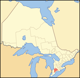
Middlesex County is a primarily rural county in Southwestern Ontario, Canada. Landlocked, the county is bordered by Huron and Perth counties on the north, Oxford County on the east, Elgin County on the south, and Chatham-Kent and Lambton County on the west.

<span class="mw-page-title-main">Peterborough County</span> County in Ontario, Canada

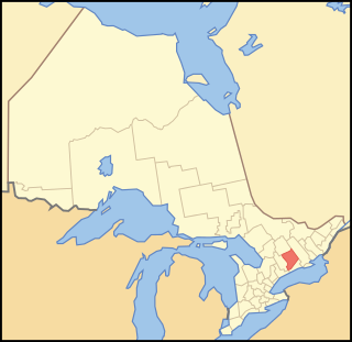
Peterborough County is located in Southern Ontario, Canada. The county seat is The City of Peterborough, which is independent of the county.

<span class="mw-page-title-main">Hastings County</span> County in Ontario, Canada

Hastings County is located in the province of Ontario, Canada. Geographically, it is located on the border of Eastern Ontario and Central Ontario. Hastings County is the second-largest county in Ontario, after Renfrew County, and its county seat is Belleville, which is independent of Hastings County. Hastings County has trademarked the moniker "Cheese Capital of Canada".

<span class="mw-page-title-main">Renfrew County</span> County in Ontario, Canada

Renfrew County is a county in the Canadian province of Ontario. It stands on the west bank of the Ottawa River. There are 17 municipalities in the county.

<span class="mw-page-title-main">Lanark County</span> County in Ontario, Canada

Lanark County is a county located in the Canadian province of Ontario. Its county seat is Perth, which was first settled in 1816 and was known as a social and political capital before being over shadowed by what we now know as Ottawa.

<span class="mw-page-title-main">Elgin County</span> County in Ontario, Canada

Elgin County is a county of the Canadian province of Ontario with a 2016 population of 50,069. Its population centres are St. Thomas, Aylmer, Port Stanley, Belmont, Dutton and West Lorne. The county seat is St. Thomas, which is separated from the county but within its geographic boundary.

<span class="mw-page-title-main">Huron County, Ontario</span> County in Ontario, Canada

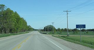
Huron County is a county of the province of Ontario, Canada. It is located on the southeast shore of its namesake, Lake Huron, in the southwest part of the province. The county seat is Goderich, also the county's largest community.

<span class="mw-page-title-main">Grey County</span> County in Ontario, Canada

Grey County is a county of the Canadian province of Ontario. The county seat is in Owen Sound. It is located in the subregion of Southern Ontario named Southwestern Ontario. Grey County is also a part of the Georgian Triangle. At the time of the Canada 2016 Census the population of the county was 93,830.

<span class="mw-page-title-main">Lambton County</span> County in Ontario, Canada

Lambton County is a county in Southwestern Ontario, Canada. It is bordered on the north by Lake Huron, which is drained by the St. Clair River, the county's western border and part of the Canada-United States border. To the south is Lake Saint Clair and Chatham-Kent. Lambton County's northeastern border follows the Ausable River and Parkhill Creek north until it reaches Lake Huron at the beach community of Grand Bend. The county seat is in the Town of Plympton-Wyoming.

<span class="mw-page-title-main">Lennox and Addington County</span> County in Ontario, Canada

Lennox and Addington County is a county and census division of the Canadian province of Ontario. The county seat is Greater Napanee. It is located in the subregion of Southern Ontario named Eastern Ontario.

Addington County was a historic county in the Canadian province of Ontario which now forms part of Lennox and Addington County. It was named after Henry Addington, 1st Viscount Sidmouth.

Lennox County is a historic county in the Canadian province of Ontario which now forms part of Lennox and Addington County. It was named after Charles Lennox, 3rd Duke of Richmond.

<span class="mw-page-title-main">Peel County, Ontario</span> Former County in Ontario, Canada

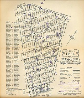
Peel County is a historic county in the Canadian province of Ontario. Named for Sir Robert Peel, Prime Minister of the United Kingdom, the county was organized in 1851. Settlers, however, were in Toronto Township as early as 1807. The Credit River was reserved for the Mississaugas; however, they sold their land and moved to the Bruce Peninsula.

Lambton—Kent was a federal electoral district in Ontario, Canada, that was represented in the House of Commons of Canada from 1935 to 1979. This riding was created in 1933 from parts of Kent, Lambton East and Lambton West ridings.

<span class="mw-page-title-main">Home District</span> Former District in Upper Canada

The Home District was one of four districts of the Province of Quebec created in 1788 in the western reaches of the Montreal District and detached in 1791 to create the new colony of Upper Canada. It was abolished with the adoption of the county system in 1849.

<span class="mw-page-title-main">Midland District, Upper Canada</span>

Midland District was one of four districts of the Province of Quebec created in 1788 in the western reaches of the Montreal District and partitioned in 1791 to create the new colony of Upper Canada.

<span class="mw-page-title-main">London District, Upper Canada</span> Former District in Upper Canada

The London District was a historic district in Upper Canada. It was formed in 1798 from parts of the Home and Western Districts, and lasted until its abolition in 1850.

<span class="mw-page-title-main">Wellington District, Upper Canada</span> Former district of Upper Canada

The Wellington District was a historic district in Upper Canada and its successor, Canada West, which existed until 1849. It was formed in June 1840 from townships transferred from certain other districts:

<span class="mw-page-title-main">Bathurst District</span>

The Bathurst District was a historic district in Upper Canada. It was created in 1822 from the Johnstown District. Containing Carleton County, it existed until 1849. The district town was Perth.

Essex was an electoral district of the Legislative Assembly of the Parliament of the Province of Canada, in Canada West, at the south-western tip of the Ontario Peninsula. It was created in 1841, upon the establishment of the Province of Canada by the union of Upper Canada and Lower Canada. Essex was represented by one member in the Legislative Assembly. It was abolished in 1867, upon the creation of Canada and the province of Ontario.

References

  1. 1 2 Proclamation of July 24, 1788
  2. 1 2 Douglas 2001, p. 8.
  3. An act for the better division of this province , S.U.C. 1798, c. 5, s. 40
  4. 1798 Act, ss. 38-40
  5. Brock, Daniel J. (1983). "Zeisburger, David". In Halpenny, Francess G (ed.). Dictionary of Canadian Biography . Vol. V (1801–1820) (online ed.). University of Toronto Press.
  6. Dalgety, Maude (1984). A History of Sombra Township. Sombra Township. p. 1.
  7. An Act for abolishing the Territorial Division of Upper-Canada into Districts, and for providing temporary Unions of Counties for Judicial and other purposes, and for the future dissolutions of such Unions, as the increase of wealth and population may require , S.Prov.C. 1849, c. 78, Sch. A-B
  8. An Act to make certain alterations in the Territorial Divisions of Upper Canada , S.Prov.C. 1851, c. 5, Sch. A, par. 32-34; Sch. B
  9. 1851 Act, Sch. C
  10. "Western District Grammar School". swoda.uwindsor.ca. South Western Ontario Digital Archive. Retrieved January 23, 2018.