Gore District, Upper Canada

Last updated
1818 map of Ontario showing Gore District A map of the province of Upper Canada describing all the settlements and townships, 1818.jpg
1818 map of Ontario showing Gore District

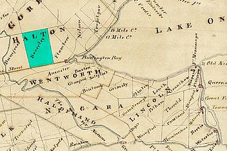
The Gore District was a historic district in Upper Canada which existed until 1849. It was formed in 1816 from parts of York County in the Home District and parts of the Niagara District. The district town was Hamilton.

District Administrative division, in some countries, managed by local government

A district is a type of administrative division that, in some countries, is managed by local government. Across the world, areas known as "districts" vary greatly in size, spanning regions or counties, several municipalities, subdivisions of municipalities, school district, or political district.

Upper Canada 19th century British colony in present-day Ontario

The Province of Upper Canada was a part of British Canada established in 1791 by the Kingdom of Great Britain, to govern the central third of the lands in British North America, formerly part of the Province of Quebec since 1763. Upper Canada included all of modern-day Southern Ontario and all those areas of Northern Ontario in the Pays d'en Haut which had formed part of New France, essentially the watersheds of the Ottawa River or Lakes Huron and Superior, excluding any lands within the watershed of Hudson Bay. The "upper" prefix in the name reflects its geographic position along the Great Lakes, mostly above the headwaters of the Saint Lawrence River, contrasted with Lower Canada to the northeast.

York County, Ontario Dissolved County in Ontario, Canada

York County is a historic county in Upper Canada, Canada West, and the Canadian province of Ontario. It was organized by the Upper Canada administration from the lands of the Toronto Purchase and others.

Two new counties were created:

In 1838, parts of Halton County and parts of Home and Huron Districts were separated to form a new Wellington District.

Wellington District, Upper Canada

The Wellington District was a historic district in Upper Canada which existed until 1849. It was formed in June 1840 from townships transferred from certain other districts:

In 1849, the district was replaced by the United Counties of Wentworth and Halton, which were separated again in 1854.

Related Research Articles

The Canadian province of Ontario has several historic counties, which are past census divisions that no longer exist today. Most historic counties either merged with other counties, or became regional municipalities or single-tier municipalities. Although counties had existed prior to 1849, after 1849 they replaced the district systems in administering local government and courts in Ontario.

Halton (electoral district) federal electoral district in Ontario

Halton was a federal electoral district in Ontario, Canada, represented in the House of Commons of Canada from 1867 to 1988 before being abolished in an electoral district redistribution, and again from 1997 to 2015, when it was again abolished in another electoral district redistribution. When it was last contested in 2011, its population was 203,437, of whom 115,255 were eligible electors.

Wentworth County, area 269,057 acres (1,089 km2), is a historic county in the Canadian province of Ontario.

Halton County is a former county in the Canadian province of Ontario. It is also one of the oldest counties in Canada.

Peel County, Ontario

Peel County is a historic county in the Canadian province of Ontario. Named for Sir Robert Peel, Prime Minister of the United Kingdom, the county was organized in 1851. Settlers, however, were in Toronto Township as early as 1807. The Credit River was reserved for the Mississaugas, however they sold their land and moved to the Bruce Peninsula.

Glanbrook, Hamilton, Ontario

Glanbrook is the south-western district of the city of Hamilton, Ontario, Canada. It was first created as an independent township in 1974 through the amalgamation of Mount Hope, Binbrook, Glanford, and other nearby communities. In 2001, Glanbrook became a dissolved municipality after it was amalgamated with Hamilton, Stoney Creek, Dundas, Ancaster and Flamborough to become the present city of Hamilton.

Burlington (electoral district) federal electoral district of Canada

Burlington is a federal electoral district in Halton Region, Ontario, Canada, that has been represented in the House of Commons of Canada since 1979.

Oakville (electoral district) Federal electoral district

Oakville is a federal electoral district in Ontario, Canada, that has been represented in the House of Commons of Canada since 1997.

Halton—Wentworth was a federal electoral district represented in the House of Commons of Canada from 1968 to 1979. It was located in the province of Ontario. This riding was created in 1966 from parts of Halton and Wentworth ridings.

Home District Former District in Upper Canada

The Home District was one of four districts of the Province of Quebec created in 1788 in the western reaches of the Montreal District and detached in 1791 to create the new colony of Upper Canada. It was abolished with the adoption of the county system in 1849.

Johnstown District, Upper Canada

The Johnstown District was a historic district in Upper Canada which existed until 1849.

London District, Upper Canada Former District in Upper Canada

The London District was a historic district in Upper Canada. It was formed in 1798 from parts of the Home and Western Districts, and lasted until its abolition in 1850.

Niagara District Former District in Upper Canada

The Niagara District was a historic district in Upper Canada. Created in 1798 from the Home District, it existed until 1849.

Bathurst District

The Bathurst District was a historic district in Upper Canada which existed until 1849. It was created in 1822 from the Johnstown District and contained Carleton County. The district town was Perth.

Burlington (provincial electoral district) provincial electoral district in Ontario, Canada

Burlington is a provincial electoral district in southwestern Ontario, Canada. It elects one member to the Legislative Assembly of Ontario.

Halton (provincial electoral district)

Halton was a provincial electoral district in Central Ontario, Canada. It elected one member to the Legislative Assembly of Ontario.

Joseph Brant Hospital is a hospital in Burlington, Ontario.

Beverley Township, Ontario

Beverley Township was a township established in 1792 in Home District in the then Upper Canada, today Ontario, Canada. It was named for the town of Beverley in the East Riding of Yorkshire, England, by John Graves Simcoe.

References

International Standard Book Number Unique numeric book identifier

The International Standard Book Number (ISBN) is a numeric commercial book identifier which is intended to be unique. Publishers purchase ISBNs from an affiliate of the International ISBN Agency.

Coordinates: 43°15′N79°52′W / 43.25°N 79.87°W / 43.25; -79.87

Geographic coordinate system Coordinate system

A geographic coordinate system is a coordinate system that enables every location on Earth to be specified by a set of numbers, letters or symbols. The coordinates are often chosen such that one of the numbers represents a vertical position and two or three of the numbers represent a horizontal position; alternatively, a geographic position may be expressed in a combined three-dimensional Cartesian vector. A common choice of coordinates is latitude, longitude and elevation. To specify a location on a plane requires a map projection.