Home District

Last updated
Home District
Former District in Upper Canada
A map of the province of Upper Canada describing all the settlements and townships, 1818.jpg
Map of Upper Canada Identifying its districts, counties and townships (1818)
Coordinates: 44°00′N79°30′W / 44°N 79.5°W / 44; -79.5 Coordinates: 44°00′N79°30′W / 44°N 79.5°W / 44; -79.5
Established1788
Dissolved1849

The Home District was one of four districts of the Province of Quebec created in 1788 in the western reaches of the Montreal District and detached in 1791 to create the new colony of Upper Canada. It was abolished with the adoption of the county system in 1849.

Contents

Territorial evolution

Originally established as Nassau District in 1788, [1] it was renamed as the "Home District" in 1792, [2] The district was originally bounded to the east by a line running north–south from the mouth of the Trent River and to the west by a line running north–south 'intersecting the extreme projection of Long Point into the lake Erie." [3] The northern boundaries were vague and overlapping Indian land. The district town was originally Newark, later Niagara-on-the-Lake.

In 1798, the Niagara District was created from Lincoln County and Haldimand County, and the London District was formed from the counties of Middlesex, Norfolk and Oxford, both of which were detached from the Home District. The remainder was organized as follows:

Organization of the Home District (1798) [4]
Northumberland County Durham County York County Simcoe County

The townships of

  • Murray
  • Cramahé
  • Haldimand
  • Hamilton
  • Elmwick
  • Percy
  • Seymour

together with the peninsula of Newcastle

The townships of

  • Hope
  • Clarke
  • Darlington

with all the tract of land ... which lies to the southward of the small lakes above the Rice Lake, and the communication between them and the communication between the eastern boundary of the township of Hope, and the western boundary of the township of Darlington, produced north fifteen degrees west, until they intersect either of the said lakes, or the communication between them...

East Riding

The townships of

  • Whitby
  • Pickering
  • Scarborough
  • York (including its peninsula)
  • Etobicoke
  • Markham
  • Vaughan
  • King
  • Whitchurch
  • Uxbridge
  • Gwillimbury

and the tract of land ... lying between the County Durham and the Lake Simcoe...

...Matchedash, Gloucester, or Penetanguishene, together with Prince William Henry's Island, [5] and all the land lying between the Midland District and a line produced due north from a certain fixed boundary (at the distance of about fifty miles north-west from the outlet of Burlington Bay) till it intersects the northern limits of the Province...
West Riding
  • the townships of Beverley and Flamborough
  • so much of the tract of land upon the Grand River in the occupation of the Six Nation Indians as lies to the northward of Dundas Street
  • all the land between the said tract and the East Riding of the County of York
  • with the reserved lands in the rear of the townships of Blenheim and Blandford

Reductions and abolition

The District was reduced in size in several steps over the coming years.

The 1798 Act had provided that counties of Durham and Northumberland, upon a request by a majority of their townships, could be detached to form the Newcastle District. [6] This occurred in 1802. [7]

In 1816, the following parts of the District were detached to form Halton County in the newly created Gore District:

...the townships of Trafalgar, Nelson, Flamborough ..., Beverly, and blocks number one, two, three and four, on the Grand river, with the reserved lands in the rear of the townships of Blandford and Blenheim... [8]

In 1837, Simcoe District was detached, consisting of Simcoe County. [9]

In 1849, the Home District was dissolved and replaced for municipal purposes by York County, [10] which was reorganized later that year to form the United Counties of York, Ontario and Peel. [11]

Further reading

Related Research Articles

<span class="mw-page-title-main">Middlesex County, Ontario</span> County in Ontario, Canada

Middlesex County is a primarily rural county in Southwestern Ontario, Canada. Landlocked, the county is bordered by Huron and Perth counties on the north, Oxford County on the east, Elgin County on the south, and Chatham-Kent and Lambton County on the west.

<span class="mw-page-title-main">Peterborough County</span> County in Ontario, Canada

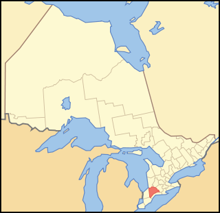
Peterborough County is located in Southern Ontario, Canada. The county seat is Peterborough, which is independent of the county.

<span class="mw-page-title-main">Hastings County</span> County in Ontario, Canada

Hastings County is located in the province of Ontario, Canada. Geographically, it is located on the border of Eastern Ontario and Central Ontario. Hastings County is the second-largest county in Ontario, after Renfrew County, and its county seat is Belleville, which is independent of Hastings County. Hastings County has trademarked the moniker "Cheese Capital of Canada".

<span class="mw-page-title-main">Simcoe County</span> County in Ontario, Canada

Simcoe County is located in the central portion of Southern Ontario, Canada. The county is just north of the Greater Toronto Area, stretching from the shores of Lake Simcoe in the east to Georgian Bay in the west. Simcoe County forms part of the Greater Golden Horseshoe area, a densely populated and industrialized region, centred on the Greater Toronto Area.

<span class="mw-page-title-main">Grey County</span> County in Ontario, Canada

Grey County is a county of the Canadian province of Ontario. The county seat is in Owen Sound. It is located in the subregion of Southern Ontario named Southwestern Ontario. Grey County is also a part of the Georgian Triangle. At the time of the Canada 2016 Census the population of the county was 93,830.

<span class="mw-page-title-main">Lennox and Addington County</span> County in Ontario, Canada

Lennox and Addington County is a county and census division of the Canadian province of Ontario. The county seat is Greater Napanee. It is located in the subregion of Southern Ontario named Eastern Ontario.

Addington County was a historic county in the Canadian province of Ontario which now forms part of Lennox and Addington County. It was named after Henry Addington, 1st Viscount Sidmouth.

Lennox County is a historic county in the Canadian province of Ontario which now forms part of Lennox and Addington County. It was named after Charles Lennox, 3rd Duke of Richmond.

<span class="mw-page-title-main">Grenville County, Ontario</span> Former county in Ontario, Canada

Grenville County is a former county in the Canadian province of Ontario. It fronted on the north shore of the Saint Lawrence River, between the towns of Kingston and Cornwall. The county was created in 1792, and named in honour of William Grenville, 1st Baron Grenville, who was the British Secretary of State responsible for the colonies in 1790. It consisted of five townships, which were settled primarily by United Empire Loyalists in the late 1700s after the Revolutionary War. Prior to being settled by Europeans, the area was home to many generations of native cultures. Grenville County merged with Leeds County in 1850 to create Leeds and Grenville County. The county covered an area of 272,261 acres (110,180 ha).

Leeds County is a historic county in the Canadian province of Ontario. The county was first surveyed in 1792 as one of the nineteen counties created by Sir John Graves Simcoe in preparation for the United Empire Loyalists to settle here. The county took its name from Francis Osborne, 5th Duke of Leeds; the "Leeds" of the Dukedom referred to Leeds in West Yorkshire, England and not for Leeds, Kent, England. In 1850, Leeds County merged with Grenville County to create the United Counties of Leeds and Grenville. This county was home to several townships as well as the city of Brockville.

Halton County is a former county in the Canadian province of Ontario, with an area of 228,181 acres (923.42 km2). It is also one of the oldest counties in Canada.

<span class="mw-page-title-main">Western District, Upper Canada</span> Former District in Upper Canada

Western District was one of four districts of the Province of Quebec created in 1788 in the western reaches of the Montreal District which were later detached in 1791 to create the new colony of Upper Canada. Known as Hesse District until 1792, it was abolished in 1849.

<span class="mw-page-title-main">Eastern District, Upper Canada</span>

Eastern District was one of four districts of the Province of Quebec created in 1788 in the western reaches of the Montreal District and partitioned in 1791 to create the new colony of Upper Canada.

<span class="mw-page-title-main">Midland District, Upper Canada</span>

Midland District was one of four districts of the Province of Quebec created in 1788 in the western reaches of the Montreal District and partitioned in 1791 to create the new colony of Upper Canada.

<span class="mw-page-title-main">Johnstown District, Upper Canada</span>

The Johnstown District was a historic district in Upper Canada which existed until 1849.

<span class="mw-page-title-main">London District, Upper Canada</span> Former District in Upper Canada

The London District was a historic district in Upper Canada. It was formed in 1798 from parts of the Home and Western Districts, and lasted until its abolition in 1850.

<span class="mw-page-title-main">Newcastle District</span>

The Newcastle District was a historic district in Upper Canada which existed until 1849. It was formed in 1802 from the Home District, consisting of the counties of Durham and Northumberland.

<span class="mw-page-title-main">Niagara District</span> Former District in Upper Canada

The Niagara District was a historic district in Upper Canada. Created in 1798 from the Home District, it existed until 1849.

<span class="mw-page-title-main">Wellington District, Upper Canada</span> Former district of Upper Canada

The Wellington District was a historic district in Upper Canada and its successor, Canada West, which existed until 1849. It was formed in June 1840 from townships transferred from certain other districts:

Lincoln North was an electoral district of the Legislative Assembly of the Parliament of the Province of Canada, in Canada West. It was created in 1841, upon the establishment of the Province of Canada by the union of Upper Canada and Lower Canada. Lincoln North was represented by one member in the Legislative Assembly. It was abolished in 1867, upon the creation of Canada and the province of Ontario.

References