French River | |
---|---|
Municipality of French River Municipalité de Rivière des Français | |
![]() The French River at the French River Post | |
Coordinates: 46°10′N80°30′W / 46.167°N 80.500°W | |
Country | Canada |
Province | Ontario |
District | Sudbury |
Incorporated | January 1, 1999 |
Government | |
• Type | Town |
• Mayor | Gisèle Pageau |
• Governing Body | French River Municipal Council |
• MP | Marc Serré (Liberal) |
• MPP | John Vanthof (NDP) |
Area | |
• Land | 717.91 km2 (277.19 sq mi) |
Population (2021) [1] | |
• Total | 2,828 |
• Density | 3.9/km2 (10/sq mi) |
Time zone | UTC-5 (EST) |
• Summer (DST) | UTC-4 (EDT) |
Area code | 705 |
Website | www |
French River, also known by the French equivalent Rivière des Français, is a municipality in the Canadian province of Ontario, in the Sudbury District. The municipality had a population of 2,828 in the 2021 Canadian census. [1] It was formed on January 1, 1999, through the merger of the Township of Cosby, Mason and Martland and surrounding unincorporated portions of the Unorganized South Sudbury District. [2] It was named after the French River, which flows through the municipality.
The borders of the municipality are composed of Highway 69 to the west (the French River Trading Post and French River Inn properties are also included within the municipal boundary), West Arm to the north on Highway 535 (just east of Shaw Rd.), the end of Wolseley Bay Rd to the east (Highway 528) and the community of Monetville to the northeast.
Along with the municipalities of St. Charles, Killarney, and Markstay-Warren, it is part of the region known as Sudbury East. [3] These communities partner together on several ventures, including the Sudbury East Planning Board, Sudbury East Municipal Association, Manitoulin-Sudbury District Services Board (MSDSB) and Sudbury East Board of Trade.
The municipality comprises the communities of Alban, Bigwood, Chartrand Corner, Delamere, Dokis First Nation, French River Station, Happy Landing, Jamot, Monetville, Noëlville, North Monetville, Ouellette, Rutter, Sucker Creek Landing and Wolseley Bay.
The community of Alban was originally established in 1907 as Rutter, named for the nearby railway station in 1907, but in 1937 the community was renamed for Rev. J. Alban Filiatrault. In 1934, the Parish of Notre-Dame-de-Lourdes was created. Jean-Baptiste Rochon donated several acres of land to the people of Alban to erect a church. During the night of February 6, 1953, the church burned to the ground. The following Sunday, Father Oliva Campeau proposed the immediate reconstruction of the church. This time, it was to be constructed with brick and the walls of plaster instead of wood.
Originally known as Martland, the community was first settled in 1895 by Cyrille Monette (né Alexandre Boisvert) and four other pioneers. It became a municipality in 1906 and adopted the name Monetville. Monetville is divided into two areas; North Monetville and Monetville. "South" Monetville is generally from Dokis Road south to Bear Lake and Shanty Bay (Baie des Chantiers) of Lake Nipissing. North Monetville extends generally from Dokis Road north to the West Arm of Lake Nipissing and Chapel Island, which Highway 64 crosses on the West Arm. North Monetville was settled by the Douglas Family, the Mercer Family and the Purcell family in the early 1900s.
On August 27, 2020, the West Nipissing Historical Society held an unveiling ceremony for the erection of a stone cairn monument in recognition of Cyrille Monette as the founder of Monetville and the first pioneer to the area. The monument bears two plaques, one in English, one in French, briefly describing M. Monette's contributions to the development of the area. This project was funded by the Society and several sponsors and donors who helped to make it possible. Cyrille Monette's original and real name was apparently 'Alexandre Boisvert', a name which he would have relinquished between 1863 and 1871 (Le lien entre Louis Riel et le Nord de l'Ontario) after participating in the Red River uprising with Louis Riel. Approximately 80 people attended the unveiling, about half of whom were descendants of the Monette family. Mayor Gisele Pageau of the Municipality of French River and Mayor Joanne Savage of West Nipissing were among the presenters. Elder Richard Meilleur of the Métis Nipissing Families shared a tobacco ceremony to honour the ancestors. The Monette Monument is located at 5690 Highway 64 in Monetville (Municipality of French River) Facebook: West Nipissing Historical Society
Noëlville, originally known as Cosby, was founded in 1905 with the arrival of settlers in the region. Noëlville families travelled by boat, to the south-west end of Lake Nipissing, to establish themselves between Lake Nipissing and the French River. To pay homage to Noël Desmarais, the village's first merchant and the first businessman of the region, the town of Cosby became Noëlville in 1911. Desmarais is a grandfather of businessman Paul Desmarais. [4] Noël Desmarais was one of the first to start his family business in Noëlville.
The North Monetville area straddles the municipal boundary between French River and West Nipissing. Designated in the 1970s to aid the delivery of supplies to the Monetville Public School, which was located several kilometers north on Highway 64 from the signposts designating the town of Monetville. Sucker Creek Landing and Chapel Island are both considered to be part of North Monetville, with Highway 64 crossing Chapel Island and bridging the West Arm Narrows of Lake Nipissing at both ends of the island. Most residents of North Monetville simply state their address as "Monetville" even if they do live in the north end of the village.
The Community of Christ cemetery, 339 East Road, [5] has a Canadian World War II hero buried there. Sgt. Wallace Edmond Firlotte, who served with the Lincoln and Welland Regiment during the war, was bestowed six war decorations. Firlotte was one of only a very few Canadians that was bestowed the Order of the Bronze Lion for heroism from the Crown of the Netherlands. This award is presented for "Deeds of extreme bravery and leadership in battle favouring the Netherlands". The Prince personally presented this Order to Sgt. Firlotte by Royal Decree on December 8, 1945.
In the 2021 Census of Population conducted by Statistics Canada, French River had a population of 2,828 living in 1,367 of its 2,098 total private dwellings, a change of
2021 | 2016 | 2011 | |
---|---|---|---|
Population | 2,828 (+6.2% from 2016) | 2,662 (+9.0% from 2011) | 2,442 (-8.2% from 2006) |
Land area | 717.91 km2 (277.19 sq mi) | 735.48 km2 (283.97 sq mi) | 735.47 km2 (283.97 sq mi) |
Population density | 3.9/km2 (10/sq mi) | 3.6/km2 (9.3/sq mi) | 3.3/km2 (8.5/sq mi) |
Median age | 58.0 (M: 58.8, F: 57.2) | 54.7 (M: 55.3, F: 54.1) | 53.7 (M: 53.8, F: 53.7) |
Private dwellings | 2,098 (total) 1,367 (occupied) | 2,108 (total) | 1,833 (total) |
Median household income | $68,000 | $60,928 |
|
| ||||||||||||||||||||||||
Statistics Canada [1] [11] |
The municipal office is located at 44 St-Christophe Street in Noëlville. The council is composed of the mayor and six councillors. The current mayor is Gisèle Pageau.
French River utilizes the mail-in balloting system for municipal elections rather than polling stations. Voter turnout in the 2010 elections was 62%. [12]
The 2019 operating budget for French River was approximately $8 million. The municipality employs approximately 30 staff and has 20 volunteer firefighters.
Northern Ontario is a primary geographic and quasi-administrative region of the Canadian province of Ontario, the other primary region being Southern Ontario. Most of the core geographic region is located on part of the Superior Geological Province of the Canadian Shield, a vast rocky plateau located mainly north of Lake Huron, the French River, Lake Nipissing, and the Mattawa River. The statistical region extends south of the Mattawa River to include all of the District of Nipissing. The southern section of this district lies on part of the Grenville Geological Province of the Shield which occupies the transitional area between Northern and Southern Ontario.
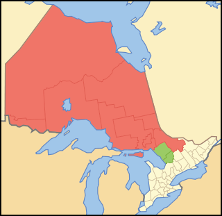
Nickel Belt is one of two federal electoral districts serving the city of Greater Sudbury, Ontario, Canada. It has been represented in the House of Commons of Canada since 1953.
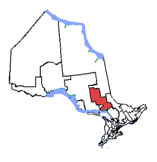
The Sudbury District is a district in Northeastern Ontario in the Canadian province of Ontario. It was created in 1894 from townships of eastern Algoma District and west Nipissing District. In 1973, the Regional Municipality of Sudbury was created as a separate jurisdiction out of the district.
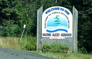
Sables-Spanish Rivers is a township in Ontario, Canada, on the north shore of Georgian Bay. It is located in the Sudbury District, approximately 70 kilometres (43 mi) west of Sudbury.
Parry Sound District is a census division of the Canadian province of Ontario. Its boundaries are District of Muskoka to the south, the Sudbury District to the north-northwest, the French River and Lake Nipissing in the north, Nipissing District and North Bay in the north and east and parts of Algonquin Park in the northeast.
Restoule is a community and designated place in geographic Patterson Township in the Centre Unorganized Part of Parry Sound District in Central Ontario, Canada. It is situated on the Restoule River between Commanda Lake, and Restoule Lake and is part of the Almaguin Highlands region.
Nipissing District is a district in Northeastern Ontario in the Canadian province of Ontario. It was created in 1858. The district seat is North Bay.
West Nipissing is a municipality in Northeastern Ontario, Canada, on Lake Nipissing in the Nipissing District. It was formed on January 1, 1999, with the amalgamation of seventeen and a half former towns, villages, townships and unorganized communities.
Burk's Falls is an incorporated village in the Almaguin Highlands region of Parry Sound District, Ontario, Canada, located 265 kilometres (165 mi) north of Toronto and 90 kilometres (56 mi) south of North Bay, Ontario. The village, and the waterfall on the site, were named by David Francis Burk of Oshawa, after he selected the land surrounding the waterfall in the Free Land Grant Act. Burk's Falls is part of the Magnetawan River waterway.
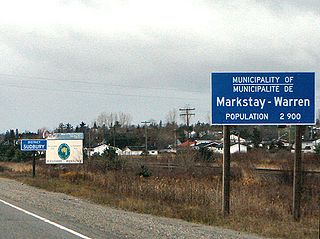
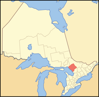
Markstay-Warren is a town in the Canadian province of Ontario, located in the Sudbury District. Highway 17, from the city limits of Greater Sudbury to the Sudbury District's border with Nipissing District, lies entirely within Markstay-Warren. The town had a population of 2,708 in the 2021 Canadian census.
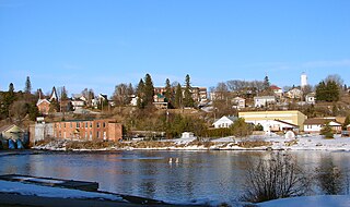
St. Charles is a town in the Canadian province of Ontario, located in the Sudbury District.
Bonfield is a township in northeastern Ontario, Canada, on the Mattawa River in Nipissing District.
East Ferris is a township in northeastern Ontario, Canada located between Trout Lake and Lake Nosbonsing in the District of Nipissing. West Ferris has long been annexed into the city of North Bay.
Nipissing is an incorporated (political) township in Parry Sound District in Central Ontario, Canada. It is on Lake Nipissing and is part of the Almaguin Highlands region. Nipissing was surveyed between 1874 and 1881, and was incorporated in 1888. Among the first settlers in the area were the Chapman and Beatty families. Nipissing Township annexed Gurd Township in 1970. The township also contains a community named Nipissing, which is located on the South River near Chapman's Landing, on the South Bay of Lake Nipissing. The township administrative offices are located in Nipissing.
King's Highway 64, commonly referred to as Highway 64, is a provincially maintained highway in the Canadian province of Ontario, connecting Highway 69 north of the French River with Highway 11 at Marten River, via Highway 17 west of Sturgeon Falls. The route serves several communities along the north shore of the French River and west shore of Lake Nipissing as it travels from Highway 69 to Highway 17. North of Sturgeon Falls, the highway provides a shortcut between Highway 17 and Highway 11 northwest of North Bay.
Northeastern Ontario is a secondary region of Northern Ontario in the Canadian province of Ontario, which lies north of Lake Huron and east of Lake Superior.
Gauthier is a township municipality in Timiskaming District the Northeastern Ontario, Canada. The township had a population of 138 in the Canada 2016 Census. Its main population centre is Dobie, located just north of Ontario Highway 66, 18.5 kilometres (11.5 mi) east of Kirkland Lake.
Dokis 9 is a First Nations reserve and community in the Canadian province of Ontario, assigned to the Dokis First Nation. The reserve is located approximately 16 kilometers southwest of central southern Lake Nipissing along the French River. It is divided into two large parts consisting of a north island, Okikendawt, and a large southern peninsula. The two land masses, which are nestled within the flows of the French river, covers 154.36 square kilometers. The French River watershed in Northern Ontario was created more than ten thousand years ago when the last ice-age receded and left a maze of rivers and small lakes. The main settlement is found on Okikendawt island which can be accessed by a gravel road which connects with Highway 64. The Land is occupied by the Dokis and its cousin tribe, the Restoule‘s. The land is well known for its hunting, fishing, fur trades, and timber.
Nipissing First Nation, meaning "place of little waters", is a long-standing community of Nishnaabeg peoples, who traditionally speak Anishinaabemwin, located along the shorelines of Lake Nipissing in northern Ontario. They are referred to by many names in European historical records, since the colonists often adopted names given to them by other nations.
The Wolf River is a river in the municipality of French River, Sudbury District in Northeastern Ontario, Canada. It is in the Great Lakes Basin and is a right tributary of the Wolseley River.