St. Charles | |
---|---|
Municipality of St. Charles Municipalité de St-Charles | |
| |
Motto: Fides Virtus Fortitudo | |
Coordinates: 46°21′N80°25′W / 46.350°N 80.417°W | |
Country | Canada |
Province | Ontario |
District | Sudbury |
Incorporated | January 1, 1999 |
Government | |
• Type | Town |
• Mayor | Paul Branconnier |
• Governing Body | St Charles Municipal Council |
• MP | Marc Serré (Liberal) |
• MPP | John Vanthof (NDP) |
Area | |
• Land | 314.46 km2 (121.41 sq mi) |
Population (2021) [1] | |
• Total | 1,357 |
• Density | 4.3/km2 (11/sq mi) |
Time zone | UTC-5 (EST) |
• Summer (DST) | UTC-4 (EDT) |
Area code | 705 |
Website | www |
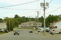
St. Charles is a town in the Canadian province of Ontario, located in the Sudbury District.
It was created on January 1, 1999, by the amalgamation of the incorporated townships of Casimir, Jennings, and Appleby, as well as a strip of unorganized territory on the West Arm of Lake Nipissing. Along with the municipalities of Markstay-Warren and French River, it is part of the region known as Sudbury East. [2]
The town had a population of 1,357 in the 2021 Canadian census. Franco-Ontarians, or Ontarians who speak French as their mother tongue, make up 41% of the population. [1]
In addition to the primary townsite at St. Charles, the municipality also includes the smaller communities of Casimir and West Arm.
In the 2021 Census of Population conducted by Statistics Canada, St.-Charles had a population of 1,357 living in 621 of its 788 total private dwellings, a change of 6.9% from its 2016 population of 1,269. With a land area of 314.46 km2 (121.41 sq mi), it had a population density of 4.3/km2 (11.2/sq mi) in 2021. [1]
2021 | 2016 | 2011 | |
---|---|---|---|
Population | 1,357 (+6.9% from 2016) | 1,269 (-1.0% from 2011) | 1,282 (+10.6% from 2006) |
Land area | 314.46 km2 (121.41 sq mi) | 321.75 km2 (124.23 sq mi) | 321.54 km2 (124.15 sq mi) |
Population density | 4.3/km2 (11/sq mi) | 3.9/km2 (10/sq mi) | 4.0/km2 (10/sq mi) |
Median age | 55.6 (M: 55.6, F: 55.2) | 53.5 (M: 53.3, F: 53.8) | 48.7 (M: 48.4, F: 49.1) |
Private dwellings | 788 (total) 621 (occupied) | 818 (total) 573 (occupied) | 759 (total) 542 (occupied) |
Median household income | $76,000 | $57,280 |
Year | Pop. | ±% |
---|---|---|
2001 | 1,245 | — |
2006 | 1,159 | −6.9% |
2011 | 1,282 | +10.6% |
2016 | 1,269 | −1.0% |
2021 | 1,357 | +6.9% |
Source: Statistics Canada [1] |
Killarney is a municipality located on the northern shore of Georgian Bay in the Sudbury District of Ontario, Canada. Killarney is commonly associated with Killarney Provincial Park, which is a large wilderness park located to the east of the townsite which occupies much of the municipality's expanded boundary.
The Nation is a municipality in Eastern Ontario, located within Canada's National Capital Region, in the United Counties of Prescott and Russell. Formed in 1998, the municipality consists of the former townships of Caledonia, Cambridge and South Plantagenet, as well as the Village of St. Isidore.
Alfred and Plantagenet is a Franco-Ontarian township in eastern Ontario, Canada, in the United Counties of Prescott and Russell. Located approximately 70 km (43 mi) from downtown Ottawa at the confluence of the Ottawa River and the South Nation River.
Champlain is a township in eastern Ontario, Canada, in the United Counties of Prescott and Russell on the Ottawa River. It was formed on January 1, 1998, through the amalgamation of West Hawkesbury Township, Longueuil Township, Town of Vankleek Hill, and the Village of L'Orignal.
The Township of Muskoka Lakes is a municipality of the District Municipality of Muskoka, Ontario, Canada. It has a year-round population of 7,652.
The Sudbury District is a district in Northeastern Ontario in the Canadian province of Ontario. It was created in 1894 from townships of eastern Algoma District and west Nipissing District. In 1973, the Regional Municipality of Sudbury was created as a separate jurisdiction out of the district.
Sables-Spanish Rivers is a township in Ontario, Canada, on the north shore of Georgian Bay. It is located in the Sudbury District, approximately 70 kilometres (43 mi) west of Sudbury.
Manitoulin District is a district in Northeastern Ontario within the Canadian province of Ontario. It was created in 1888 from part of the Algoma District. The district seat is in Gore Bay.
Nipissing District is a district in Northeastern Ontario in the Canadian province of Ontario. It was created in 1858. The district seat is North Bay.
West Nipissing is a municipality in Northeastern Ontario, Canada, on Lake Nipissing in the Nipissing District. It was formed on January 1, 1999, with the amalgamation of seventeen and a half former towns, villages, townships and unorganized communities.
French River, also known by the French equivalent Rivière des Français, is a municipality in the Canadian province of Ontario, in the Sudbury District. The municipality had a population of 2,828 in the 2021 Canadian census. It was formed on January 1, 1999, through the merger of the Township of Cosby, Mason and Martland and surrounding unincorporated portions of the Unorganized South Sudbury District. It was named after the French River, which flows through the municipality.
Markstay-Warren is a town in the Canadian province of Ontario, located in the Sudbury District. Highway 17, from the city limits of Greater Sudbury to the Sudbury District's border with Nipissing District, lies entirely within Markstay-Warren. The town had a population of 2,708 in the 2021 Canadian census.
Hearst is a town in the district of Cochrane, Ontario, Canada. It is located on the Mattawishkwia River in Northern Ontario, approximately 92 kilometres (57 mi) west of Kapuskasing, approximately 520 kilometres (320 mi) east of Thunder Bay along Highway 11. At Hearst, Highway 583 extends northward to Lac-Sainte-Thérèse and southward to Jogues, Coppell and Mead.
Southwold is a township in Elgin County, in Ontario, Canada, located on the north shore of Lake Erie. It is a rich agricultural zone producing predominantly corn and soybeans. It is part of the London census metropolitan area.
Johnson is a township in the Canadian province of Ontario, located within the Algoma District. The township had a population of 751 in the Canada 2016 Census, up from 750 in the 2011 census.
Cartier is a community in the Canadian province of Ontario, located in the Sudbury District approximately 20 kilometres (12 mi) north of the northwestern city limits of Greater Sudbury along Highway 144.
Macdonald, Meredith and Aberdeen Additional is a township in Algoma District, Ontario, Canada. Originally surveyed as separate geographical townships, Macdonald and Meredith were incorporated as a single, municipal township in 1892. The geographical township of Aberdeen Additional was added to Macdonald and Meredith township in 1899 to create the municipal township of Macdonald, Meredith and Aberdeen Additional.
Unorganized North Sudbury District is an unorganized area in the Canadian province of Ontario, comprising all portions of the Sudbury District which are not organized into incorporated municipalities. Despite its name, there is no longer an accompanying "South Part", as that subdivision has been dissolved in 1999 and incorporated into municipalities, and Statistics Canada has not renamed the North Part.
Coleman is a township municipality in the Canadian province of Ontario. It is situated in the Timiskaming District of Northeastern Ontario. The township had a population of 595 in the Canada 2016 Census.
Warwick is a rural township in Lambton County, Ontario, Canada, with a population (2016) of 3,692.