Mumbai Harbour, is a natural deep-water harbour in the southern portion of the Ulhas River estuary. The narrower, northern part of the estuary is called Thana Creek. The harbour opens to the Arabian Sea to the south. The historical island of Elephanta is one of the six islands that lie in the harbour.

Spencer's Island is a rural community in Cumberland County, Nova Scotia, located at the western end of Greville Bay on the Bay of Fundy. The community is named after a small island 45°19′50″N64°41′30″W of the same name located offshore from nearby Cape Spencer. According to local oral history, the island, cape and community trace their name to a man named Spencer who is buried on the island. However the name more likely comes from Lord Spencer, a British statesman at the time the community was settled.

Advocate Harbour is a rural community located in Cumberland County, Nova Scotia, Canada.

Parrsboro is a community located in Cumberland County, Nova Scotia, Canada.
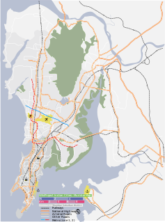
The Fundy Shore Ecotour is a former scenic drive and network of tourist destinations in the Canadian province of Nova Scotia and encircles several sub-basins of the Bay of Fundy, which contains the highest tidal range on the planet.
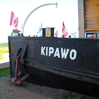
MV Kipawo is a historic Canadian passenger and freight ferry built to operate in the Bay of Fundy and which later served in Newfoundland and inspired the creation of a theater company. It was the 33rd and last ferry to provide service across Minas Passage, service which had been provided since the Acadian era.
Springhill Junction is a Canadian rural community in central Cumberland County, Nova Scotia approximately 4 kilometres (2.5 mi) northwest of Springhill, Nova Scotia.

Parrsboro Regional High School also known as PRHS is a school located in Parrsboro, Nova Scotia, Canada. PRHS consists of six grades- 7,8,9,10,11 and 12, with approximately 150 students and with 1 class per grade.

Partridge Island is a significant historical, cultural and geological site located near the mouth of Parrsboro Harbour and the town of Parrsboro on the Minas Basin, in Cumberland County, Nova Scotia. It attracts many visitors including sightseers, swimmers, photographers, hikers and amateur geologists. Partridge Island is actually a peninsula that is connected to the mainland by a sandbar isthmus. According to local legend, the isthmus was created during the Saxby Gale of 1869. The hiking trail to the top of the island affords scenic views of key landforms on the Minas Basin including Cape Blomidon, Cape Split and Cape Sharp. The nearby Ottawa House By-the-Sea Museum contains artifacts and exhibits illustrating the history of the former village at Partridge Island, which dates from the 1770s. Partridge Island is a favourite hunting ground for rockhounds because its ancient sandstone and basalt cliffs are steadily eroded by the fast-moving currents of the world's highest tides. Rocks and debris worn away from its cliffs are dragged down the beach making it possible to find gemstones, exotic-looking zeolite minerals and fossils. Fossil hunters are warned, however, that although one or two loose specimens may be collected, Nova Scotia law requires that they be sent or taken to a museum for further study, and no fossils may be excavated from bedrock without a permit.
Farrells River, formerly known as Parrsboro River, is a small river that flows south into an aboiteau on Parrsboro Harbour on the Minas Basin near the town of Parrsboro, Nova Scotia.

Victoria Harbour is a harbour, seaport, and seaplane airport in the Canadian city of Victoria, British Columbia. It serves as a cruise ship and ferry destination for tourists and visitors to the city and Vancouver Island. It is both a port of entry and an airport of entry for general aviation. Historically it was a shipbuilding and commercial fishing centre. While the Inner Harbour is fully within the City of Victoria, separating the city's downtown on its east side from the Victoria West neighbourhood, the Upper Harbour serves as the boundary between the City of Victoria and the district municipality of Esquimalt. The inner reaches are also bordered by the district of Saanich and the town of View Royal. Victoria is a federal "public harbour" as defined by Transport Canada. Several port facilities in the harbour are overseen and developed by the Greater Victoria Harbour Authority, however the harbour master's position is with Transport Canada.
Eatonville is a former lumber and shipbuilding village in Cumberland County, Nova Scotia. It includes a large tidal harbour at the mouth of the Eatonville Brook beside several dramatic sea stacks known as the "Three Sisters". It was founded in 1826 and abandoned in the 1940s. The site of the village is now part of Cape Chignecto Provincial Park.
Hall's Harbour is a fishing community in the Canadian province of Nova Scotia, located in Kings County on the North Mountain along the shore of the Bay of Fundy.
Apple River is a community in the Canadian province of Nova Scotia, located in Cumberland County.

The Age of Sail Heritage Centre is a museum and heritage centre at Port Greville, Nova Scotia, Canada. It focuses on the history of Parrsboro Shore communities along the Minas Channel of the Bay of Fundy with an emphasis on the area's shipbuilding and lumbering heritage.
There are various Black Lakes in Nova Scotia, Canada. They vary widely in size, depth and usability. Many counties, such as Cumberland, Halifax, Inverness, and Pictou Counties have more than one Black Lake so named, while other counties mentioned in this article have only one named Black Lake.

The Parrsboro Shore is an area of Cumberland County, Nova Scotia consisting of the shoreline communities west of the town of Parrsboro. The Parrsboro Shore is generally defined as stretching along the Bay of Fundy from the town of Parrsboro westward around Cape Chignecto as far as Apple River. It includes the communities of Diligent River, Fox River, Port Greville, Ward's Brook, Fraserville, Spencer's Island, Advocate, the ghost town of Eatonville. Linked by Nova Scotia's Route 209, the communities form part of the Fundy Shore Ecotour.
St. George's Anglican Church is an historic Carpenter Gothic style Anglican church building located at 216 Main Street in Parrsboro, Nova Scotia, Canada.
The Battle of Mudeford was a skirmish fought between smugglers and Customs and Excise officers which occurred in 1784 on what is now a car park at Mudeford Quay, Mudeford, Christchurch, England near the entrance of Christchurch Harbour. The battle showed how widespread smuggling was at the time and resulted in the death of a Customs officer and subsequent trial and execution of one of the smugglers.
St. George's Bay is a bay with shore on the Nova Scotia peninsula and Cape Breton Island, Canada, thus comprising a sub-basin of the Gulf of St. Lawrence.

