
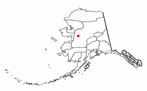
Yukon–Koyukuk Census Area is a census area in the U.S. state of Alaska. As of the 2010 census, the population was 5,588. It has the largest area of any county or county-equivalent in the United States. It is part of the unorganized borough of Alaska and therefore has no borough seat. Its largest communities are the cities of Galena, in the west, and Fort Yukon, in the northeast.

Bethel is the largest community on the Kuskokwim River, located approximately 50 mi (80 km) upriver from where the river flows into Kuskokwim Bay. Bethel is the largest community in western Alaska and in the Unorganized Borough, as well as the 9th largest in the state, with a population of 6,080 as of the 2010 Census. Bethel is home to the lone detention center in southwestern Alaska, the Yukon Kuskokwim Correction Center.

Fort Yukon is a city in the Yukon-Koyukuk Census Area in the U.S. state of Alaska. The population, predominately Gwich'in Alaska Natives, was 583 at the 2010 census, down from 595 in 2000.
Koyukuk is a city in Yukon-Koyukuk Census Area, Alaska, United States. At the 2010 census the population was 96, down from 101 in 2000.

Nulato is a city in Yukon-Koyukuk Census Area, Alaska, United States. At the 2000 census the population was 336.
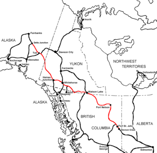
The Alaska Highway was constructed during World War II for the purpose of connecting the contiguous United States to Alaska across Canada. It begins at the junction with several Canadian highways in Dawson Creek, British Columbia, and runs to Delta Junction, Alaska, via Whitehorse, Yukon. Completed in 1942 at a length of approximately 1,700 miles (2,700 km), as of 2012 it is 1,387 mi (2,232 km) long. The difference in distance is due to constant reconstruction of the highway, which has rerouted and straightened out numerous sections. The highway was opened to the public in 1948. Legendary over many decades for being a rough, challenging drive, the highway is now paved over its entire length. Its component highways are British Columbia Highway 97, Yukon Highway 1 and Alaska Route 2.

The Yukon Quest 1,000-mile International Sled Dog Race, or simply Yukon Quest, is a sled dog race run every February between Fairbanks, Alaska, and Whitehorse, Yukon. Because of the harsh winter conditions, difficult trail, and the limited support that competitors are allowed, it is considered the "most difficult sled dog race in the world", or even the "toughest race in the world"—"even tougher, more selective and less attention-seeking than the Iditarod Trail Sled Dog Race." The originator envisioned it as "a race so rugged that only purists would participate."

The Andreafsky River is a 120-mile (190 km) tributary of the Yukon River in the U.S. state of Alaska. The Andreafsky flows south from near Iprugalet Mountain in the Yukon Delta National Wildlife Refuge to meet the larger river at Pitkas Point, near the village of St. Mary's.

Beaver Creek is a 180-mile (290 km) tributary of the Yukon River in the U.S. state of Alaska. The creek begins at the confluence of Champion and Bear creeks in the White Mountains National Recreation Area, about 50 miles (80 km) north of Fairbanks. From there it flows west around the southern end of the White Mountains, then northeast into the Yukon Flats National Wildlife Refuge, then west into the Yukon River downstream of Beaver.

Birch Creek is a 150-mile (240 km) tributary of the Yukon River in the U.S. state of Alaska. Beginning at the confluence of Ptarmigan and Eagle creeks near Porcupine Dome, it flows southwest, then south under the Steese Highway and into the Steese National Conservation Area. It then turns east, then north, again passing under the Steese Highway and entering the Yukon Flats National Wildlife Refuge. Turning northwest, it ends where it splits into two distributaries, Lower Mouth Birch Creek and Upper Mouth Birch Creek, near Birch Creek, Alaska. The distributaries flow into the Yukon River at separate locations downstream of Fort Yukon.

The Charley River is an 88-mile (142 km) tributary of the Yukon River in the U.S. state of Alaska. Flowing generally northeast from the Mertie Mountains in the northeastern part of the state, the river lies entirely within Yukon–Charley Rivers National Preserve. The Charley River enters the larger river downstream and 55 miles (89 km) southwest of Eagle.

The Fortymile River is a 60-mile (97 km) tributary of the Yukon River in the U.S. state of Alaska and the Canadian territory of Yukon. Beginning at the confluence of its north and south forks in the Southeast Fairbanks Census Area, the Fortymile flows generally northeast into Canada to meet the larger river 32 miles (51 km) southeast of Eagle, Alaska.
The Canol Road was part of a project to build the Canol pipeline and a road from Norman Wells, Northwest Territories, to Whitehorse, Yukon, during World War II. The pipeline no longer exists, but the 449 kilometres (279 mi) long Yukon portion of the road is maintained by the Yukon Government during summer months. The portion of the road that still exists in the NWT is called the Canol Heritage Trail. Both road and trail are incorporated into the Trans-Canada Trail.

The Tagish Road is a 33-mile (53-kilometre) road, now hard surfaced, that links Jake's Corner on the Alaska Highway with Carcross, Yukon on the Klondike Highway. One mile (1.6 km) from Jake's Corner is the terminus of the Atlin Road. The small community of Tagish is located 12 miles (19 km) from Jake's Corner.

Yukon–Charley Rivers National Preserve is a United States national park and preserve located in east central Alaska along the border with Canada. Managed by the National Park Service, the preserve encompasses 115 miles (185 km) of the 1,800-mile (3,000 km) Yukon River and the entire Charley River basin. The preserve protects the undeveloped Charley River and a significant portion of the upper Yukon. The interior Alaskan region experiences extremes of weather, with temperatures that can vary from −50 °F (−46 °C) in winter to 97 °F (36 °C) in summertime. The Yukon provided a means of access to the region, which is entirely roadless, during the late 19th century and early 20th centuries. Gold rushes in Alaska brought prospectors, who operated gold dredges to recover significant quantities of placer gold from area creeks. Today the preserve includes part of the route of the annual Yukon Quest dogsled race, which runs every February. During the summer float trips are popular on the Yukon and Charley Rivers.

Southwest Alaska is a region of the U.S. state of Alaska. The area is not exactly defined by any governmental administrative region(s); nor does it always have a clear geographic boundary.
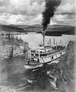
Steamboats on the Yukon River played a role in the development of Alaska and Yukon. Access to the interior of Alaska and Yukon was hindered by large mountains and distance, but the wide Yukon River provided a feasible route. The first steamers on the lower Yukon River were work boats for the Collins Overland Telegraph in 1866 or 1867, with a small steamer called Wilder. The mouth of the Yukon River is far to the west at St. Michael and a journey from Seattle or San Francisco covered some 4,000 miles (6,400 km).
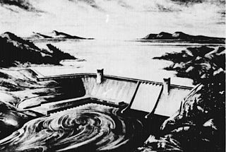
A project proposed in 1954 by the U.S. Army Corps of Engineers to dam the Yukon River in Alaska for hydroelectric power called Rampart Dam or Rampart Canyon Dam. Planned for Rampart Canyon just 31 miles (50 km) southwest of the village of Rampart, Alaska and about 105 miles (169 km) west-northwest of Fairbanks, Alaska, the resulting dam would have created a lake roughly the size of Lake Erie, making it the largest man-made reservoir in the world. The plan for the dam itself called for a concrete structure 530 feet (162 m) high with a top length of about 4,700 feet (1,430 m). The proposed power facilities would have consistently generated between 3.5 and 5 gigawatts of electricity, based on the flow of the river as it differs between winter and summer.


