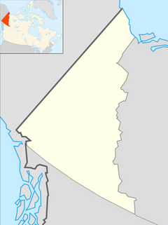
Yukon is the smallest and westernmost of Canada's three territories. It is the second-least populated province or territory in Canada, with a population of 44,975 as of 2023. However, Whitehorse, the territorial capital, is the largest settlement in any of the three territories.

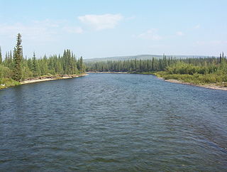
The Yukon River is a major watercourse of northwestern North America. From its source in British Columbia, Canada, it flows through Canada's territory of Yukon. The lower half of the river continues westward through the U.S. state of Alaska. The river is 3,190 kilometres (1,980 mi) long and empties into the Bering Sea at the Yukon–Kuskokwim Delta. The average flow is 6,400–7,000 m3/s (230,000–250,000 cu ft/s). The total drainage area is 833,000 km2 (321,500 sq mi), of which 323,800 km2 (125,000 sq mi) lies in Canada. The total area is more than 25% larger than Texas or Alberta.
The Indian River is a river in Lanark County in Eastern Ontario, Canada. It is in the Saint Lawrence River drainage basin and is a left tributary of the Mississippi River.

The York River is a river in Renfrew County, Hastings County and Haliburton County in Ontario, Canada. The river is in the Saint Lawrence River drainage basin, and flows from the southern extension of Algonquin Provincial Park to the Madawaska River.

The Indian River is a river in Renfrew County and Nipissing District in Eastern and Northeastern Ontario, Canada. It is in the Saint Lawrence River drainage basin, and is a left tributary of the Muskrat River.

Dawson City, officially the City of Dawson, is a city in the Canadian territory of Yukon. It is inseparably linked to the Klondike Gold Rush (1896–1899). Its population was 1,577 as of the 2021 census, making it the second-largest city in Yukon.

Carmacks is a village in Yukon, Canada, on the Yukon River along the Klondike Highway, and at the west end of the Robert Campbell Highway from Watson Lake. The population is 588, an increase from the Census of 2016. It is the home of the Little Salmon/Carmacks First Nation, a Northern Tutchone-speaking people.
The Klondike River is a tributary of the Yukon River in Canada that gave its name to the Klondike Gold Rush and the Klondike region of the Yukon Territory. The Klondike River rises in the Ogilvie Mountains and flows into the Yukon River at Dawson City.

The Pelly River is a river in Canada, and is a headstream of the Yukon River. The river originates west of the Mackenzie Mountains and flows 530 km (330 mi) long through the south central Yukon. The Pelly has two main tributaries, the Ross and Macmillan rivers.

Yukon is in the northwestern corner of Canada and is bordered by Alaska and the Northwest Territories. The sparsely populated territory abounds with natural scenery, snowmelt lakes and perennial white-capped mountains, including many of Canada's highest mountains. The territory's climate is Arctic in territory north of Old Crow, subarctic in the region, between Whitehorse and Old Crow, and humid continental climate south of Whitehorse and in areas close to the British Columbia border. Most of the territory is boreal forest with tundra being the main vegetation zone only in the extreme north and at high elevations.

The history of Yukon covers the period from the arrival of Paleo-Indians through the Beringia land bridge approximately 20,000 years ago. In the 18th century, Russian explorers began to trade with the First Nations people along the Alaskan coast, and later established trade networks extending into Yukon. By the 19th century, traders from the Hudson's Bay Company were also active in the region. The region was administered as a part of the North-Western Territory until 1870, when the United Kingdom transferred the territory to Canada and it became the North-West Territories.
Gold mining in Alaska, a state of the United States, has been a major industry and impetus for exploration and settlement since a few years after the United States acquired the territory in 1867 from the Russian Empire. Russian explorers discovered placer gold in the Kenai River in 1848, but no gold was produced. Gold mining started in 1870 from placers southeast of Juneau, Alaska.

Gold Rush is a reality television series that airs on Discovery and its affiliates worldwide. The series follows the placer gold mining efforts of various family-run mining companies, mostly in the Klondike region of Dawson City, Yukon, Canada, as well as in the U.S. state of Alaska. In its 12th season as of early 2021, prior seasons also included mining efforts in South America and western North America.
The Klondike Gold Rush is commemorated through film, literature, historical parks etc.
The Indian River is a river in the Lower Mainland region of British Columbia, Canada. It is in the Pacific Ocean drainage basin, and is a tributary of Indian Arm.
Pioneer Creek is a tributary of Baker Creek in the U.S. state of Alaska. Other Baker tributaries in the vicinity include Eureka, Thanksgiving, and Gold Run.

Sixtymile River is a tributary of the Yukon River, which heads in the U.S. state of Alaska before crossing into Yukon, Canada.
The Matawin River is a river in Thunder Bay District in Northwestern Ontario, Canada. It is in the Great Lakes Basin and is a right tributary of the Kaministiquia River.
Mess Creek, formerly known as Mestua, is a tributary of the Stikine River in northwestern British Columbia, Canada. It flows north and northwest for about 110 km (68 mi), through a lake and a gorge to join the Stikine River, which in turn flows southwest across the Canada–United States border into Alaska where it empties into various straits of the Inside Passage. The northern half of Mess Creek forms a western boundary of Mount Edziza Provincial Park which lies within the traditional territory of the Tahltan people.